-
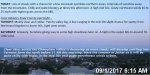
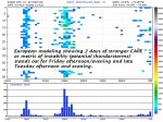
- image0011
-
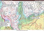
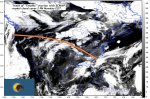
- image0021
-

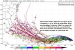
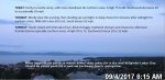
- image003
-
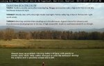
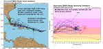
- image0041
-
- image005
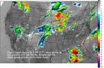
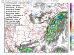
TODAY: Partly to mostly sunny, with more cloudiness far northern areas. A high 75 to 80. Southwesterly breeze 10 to occasionally 20 mph.
TONIGHT: Mostly clear this evening, then clouding up overnight. A rising chance for showers after midnight for northern areas. Mild with a low 60 to 65. South breeze 10 mph.
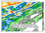
TUESDAY: Clouds mixed with intervals of sun. Kind of muggy. Scattered showers and chance for afternoon thunderstorms especially southern areas. A high 70 to 75. Southwest breeze 10 to 15 mph.
Looking further ahead…
TUESDAY NIGHT: Partly cloudy northern and eastern areas. Cloudy with a chance for lingering showers south and east of Barre-Montpelier area. A low around 55.
WEDNESDAY: Mostly cloudy. A high in the mid to upper 60s.
THURSDAY: Lots of clouds with a chance for rain or showers. A low 50 to 55. A high in the 60s.
FRIDAY: Mixed clouds and sunshine. Scattered mainly afternoon showers. A low around 45. A high in the in the low to mid 60s.
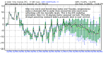
Average low upper 40s to low 50s. Normal highs 70 to 75.
RH/9-4 [end]
| Virus-free. www.avast.com |