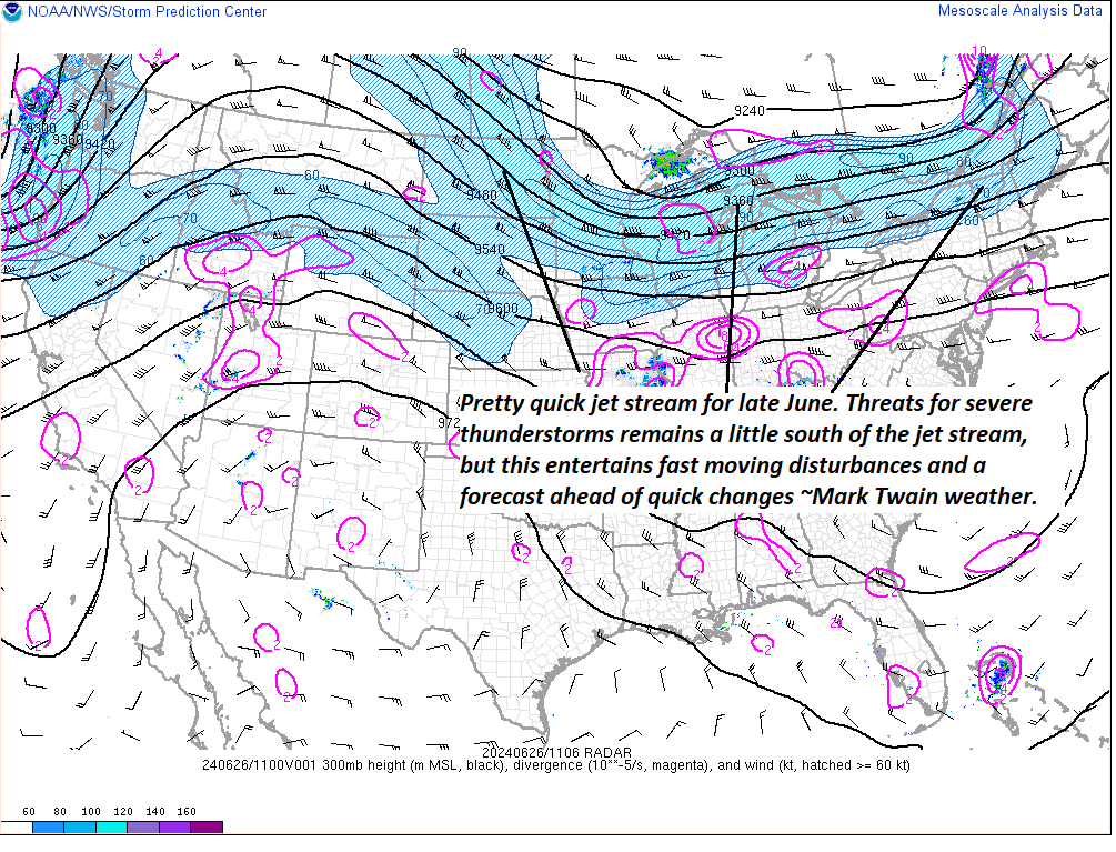
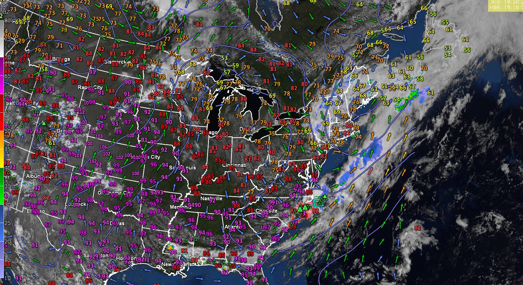
High-speed ribbon of air is moving right along, which makes for fast changeable weather over the next few to several days. Best weather days Friday and Tuesday into Wednesday next week.


TONIGHT: Becoming mostly cloudy. Rising chance for showers and an isolated rumble of thunder overnight. More muggy. A low in the mid-60s. Light south to southwest winds breezier near Lake Champlain.
TOMORROW: A leftover shower or two early, then partly to mostly sunny before more afternoon clouds. Warmer and a little muggier. A high in the low 80s. West breeze 10 to 15 mph in the afternoon.
WEDNESDAY NIGHT: Mainly cloudy. Good chance for showers and a few heavy thunderstorms possible southern areas. Partial clearing late. A low near 60. Light southwest winds.
THURSDAY: Mixed sun and clouds. A few passing showers with isolated rumbles of thunder mid-afternoon or so. A high 70 to 75. West to northwest breeze 10 to 15 mph.
Looking further ahead
THURSDAY NIGHT: Clear & partially moonlit. Patchy valley fog. A low about 50.
FRIDAY: Mostly sunny and cool after patchy valley fog. A high upper 60s.
SATURDAY: Mainly cloudy. Rising chance for rain or showers, maybe some rumbles of thunder in the evening. A low 50 to 55. A high in the 70s.
SUNDAY: Transition day. Clouds with a chance for lingering showers, gives way to periods of afternoon sunshine. More humid. A low in the lower 60s. A high in the low 80s.
Average lows low to mid 50s. Average high mid-70s to low 80s

RH/6-24forecast][end]

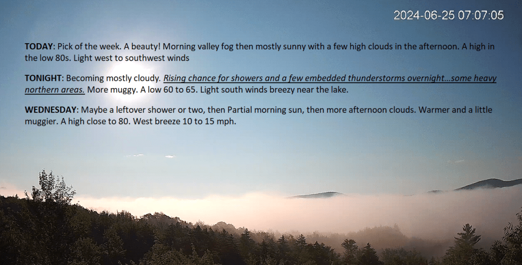
TODAY: Pick of the week. A beauty! Morning valley fog then mostly sunny with a few high clouds in the afternoon. A high in the low 80s. Light west to southwest winds
TONIGHT: Becoming mostly cloudy. Rising chance for showers and a few embedded thunderstorms overnight…some heavy northern areas. More muggy. A low 60 to 65. Light south winds breezy near the lake.
WEDNESDAY: Maybe a leftover shower or two, then Partial morning sun, then more afternoon clouds. Warmer and a little muggier. A high close to 80. West breeze 10 to 15 mph.

Looking further ahead
WEDNESDAY NIGHT: Mainly cloudy. Good chance for showers and a few heavy thunderstorms mainly southern areas. Partial clearing toward daybreak. A low near 60.
THURSDAY: Mixed sun and clouds. A few passing showers with isolated rumbles of thunder mid-afternoon or so. A high 70 to 75.
FRIDAY: Mostly sunny and cool after patchy valley fog. A low in the upper 40s. A high upper 60s.
SATURDAY: Mainly cloudy. Rising chance for rain or showers, maybe some rumbles of thunder in the evening. A low in the low 50s. A high in the 70s.
SUNDAY: Transition day. Clouds with a chance for lingering showers, gives way to periods of afternoon sunshine. More humid. A low around 60. A high around 80.

Average lows low to mid 50s. Average high mid-70s to low 80s
RH/6-24forecast][end]
TONIGHT: A few early showers dry up, then becoming mostly clear & partially moonlit with patchy valley fog. A low near 55. Light west to northwest winds.
TOMORROW: Pick of the week. A beauty! Morning valley fog then mostly sunny with a few high clouds in the afternoon. A high in the low 80s. Light west to southwest winds

TUESDAY NIGHT: Becoming mostly cloudy. Scattered showers late evening into the overnight. A low in the mid-60s. Light south winds breezy near the lake.
WEDNESDAY: Partial morning sun, then more afternoon clouds. Warmer and a little muggier. Chance for a shower or thunderstorm southern areas. A high in the low 80s. West breeze 10 to 15 mph.
Looking further ahead

WEDNESDAY NIGHT: Lots of clouds. Good chance for showers and few heavy thunderstorms. A low upper 50s.
THURSDAY: Clouds with some intervals of sun. A few mountain sprinkles. A high in the low 70s.
FRIDAY: Partly to mostly sunny. A low in the upper 40s. A high in the upper 60s.

SATURDAY: Mainly cloudy. A low in the low 50s. A high in the 70s.
Average lows low to mid 50s. Average high mid-70s to low 80s
RH/6-24forecast][end]

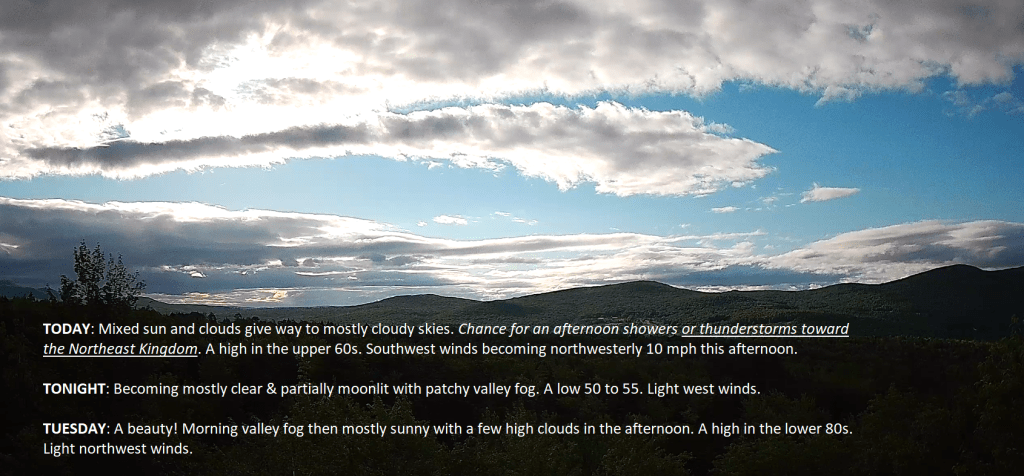
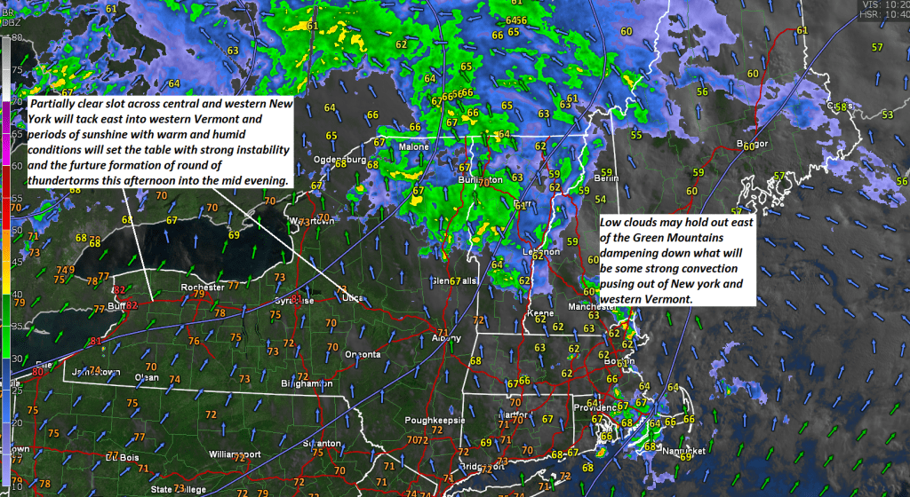
TODAY: Mixed sun and clouds give way to mostly cloudy skies. Chance for an afternoon shower or thunderstorm toward the Northeast Kingdom. A high in the upper 60s. Southwest winds becoming northwesterly 10 mph this afternoon.
TONIGHT: Becoming mostly clear & partially moonlit with patchy valley fog. A low 50 to 55. Light west winds.
TUESDAY: A beauty! Morning valley fog then mostly sunny with a few high clouds in the afternoon. A high in the lower 80s. Light northwest winds.

Looking further ahead
TUESDAY NIGHT: Evening cloudiness. Chance for an evening shower or thunderstorm…becoming mostly clear partially moonlit overnight. A low in the low to mid 60s.
WEDNESDAY: Morning sun, then more afternoon clouds. Warmer and more humid. Scattered afternoon thunderstorms mainly southern areas. A high 80 to 85.

THURSDAY: Some early morning clouds, then partly to sunny. A low 60 to 65. A high in the mid to upper 70s.
FRIDAY: Partly to mostly sunny. A low 45 to 50. A high in the upper 60s
Average lows low to mid 50s. Average high mid-70s to low 80s
RH/6-24forecast][end]