
Turkey Day PM Snowfall – Gobble gobble… With cold enough air in place a quick moving area of low pressure spins up and quickly tracks out of the Ohio Valley to the Long Island coast and across S. New England. Quick shot of half foot or more in some southern mountain locations.

Freezing ground temperatures and rain causing some glazing this morning, but conditions shall improve as warmer air pushes in aloft and mixes down to surface erasing the icy spots in a few hours
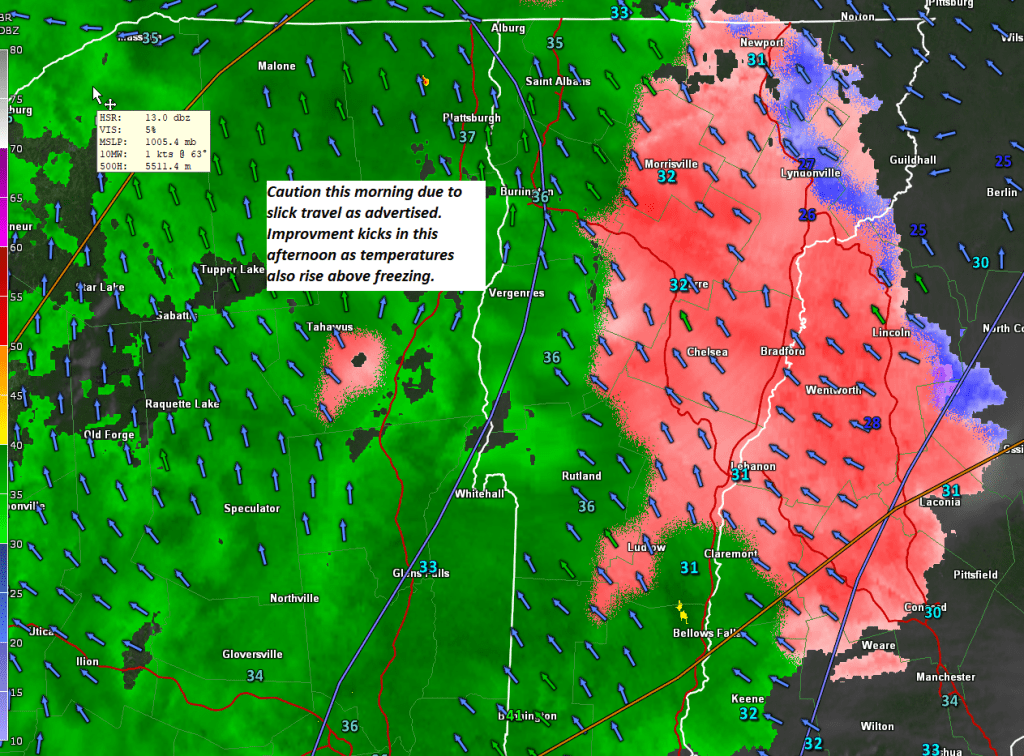
Spotty freezing rain – “icy” spots tomorrow morning. Better weather follows Wednesday into first part of Thursday. Thereafter — Winter Wonderland with a wet snowfall Thursday afternoon into Friday AM.
I plan on returning to Radio Vermont Group next Monday Afternoon. We have some incoming weather issues ahead. Some spotty freezing rain – Tuesday morning (elevation plays a role) and Incoming snow event Thursday Thanksgiving Afternoon into Friday with likely snow cover of a few inches, but poor travel, and potentially some power outages. I will cover with a video by mid day or sooner.
Big warming push next 24 hours comes with border skirmishes of sprinkles light rain shower activity. Overall this more unsettled than last week, not as warm, no huge wash-outs and on the dry side.
Roger Hill’s Weathering Heights Forecast 10:45 AM Monday November 4th, 2024
THIS AFTERNOON: Considerable cloudiness. A high around 45. Southeast winds 10 mph.
TONIGHT: Overcast. Widely scattered rain showers northern areas. A low in the low 40s. Light south winds stronger near Lake Champlain.
TOMORROW: Morning clouds with a chance for rain showers. Partial afternoon sunshine. A high near 65. South winds 10 to 15 mph, stronger near Lake Champlain.
Looking further ahead
TUESDAY NIGHT: Fair with some high cloudiness. A low in the in the upper 50s.
WEDNESDAY: Gray.Good chance of rain showers. Late day breaks of sun. A high mid to upper 60s.
THURSDAY: Morning clouds with leftover rain showers exiting. Increasing afternoon sunshine.A low near 40. A high 50 to 55.
FRIDAY: Morning sun then thickening clouds leading to a few showers north.A low around 35. A high around 50.
Average low mid-20s to low 30s. Average high mid-40s to low 50s
Full out stick season
This forecast and weather brief will be done every other day – Monday, Wednesday & Fridays until further notice.
RH/11-4forecast][end]
Blustery, drier and colder but still lingering clouds and sprinkles. Decent weather, though chilly, this weekend into Monday, warmer & dry Election Day.
Roger Hill’s Weathering Heights Forecast 10:45 AM Friday, November 1st, 2024
THIS AFTERNOON: Mixed sun and clouds & colder, maybe a mountain sprinkle. Blustery to windy. Temperatures falling through the 50s. West winds 10 to 25 mph shifting to northwesterly.
TONIGHT: Cloudy periods. A low 32 to 35. Northwesterly winds becoming light.
TOMORROW: Lots of clouds, with intervals of sun away from the mountains. Slightly below normal in temperature. A high low to mid-40s. Northwest winds 10 mph.
Looking further ahead
SATURDAY NIGHT: Becoming clear and cold with a hard freeze. A low mid to upper 20s.
SUNDAY: Bright sunshine gives way to variable high cloudiness. A high around 45.
MONDAY: Clouding up. Chance for rain showers. A high low to mid-40s.
TUESDAY Election Day: Morning clouds then lots of sunshine. Much milder with a high in the low to mid 60s.
Average low upper 20s to low 30s. Average high mid-40s to low 50s
Full-out stick season
This forecast and weather brief will be done every other day – Monday, Wednesday & Fridays until further notice.
RH/11-1forecast][end]
Big warm up on the way with transition of moisture exiting as well. Record high temps tomorrow. Minor weather systems with more oscillation ahead.
Roger Hill’s Weathering Heights Forecast 10:45 AM Wednesday, October 30th, 2024
THIS AFTERNOON: Lots of clouds. Some hints of sunshine and turning much milder later today, with a high in the mid-60s. South breeze 10 mph.
TONIGHT: Fair but with considerable high cloudiness. A low 50 to 55. Light southwest winds.
TOMORROW: Morning high clouds give way to periods of afternoon sunshine. Record warmth, highs in the mid-70s. Southwest winds 10 to 15 mph.
Looking further ahead
THURSDAY NIGHT Halloween: Cloudy. Rising likelihood for showers. A low in the mid to upper 50s.
FRIDAY: Considerable cloudiness. Widely scattered leftover mountain sprinkles. A morning high in the low 60s falling into the 40s in the afternoon.
SATURDAY: Morning clouds with a couple wet snow lakes in the hills…then intervals of sunshine. A low upper 30s around 40. A high in the low to mid 40s.
SUNDAY: Sunny. Lows in the low 30s. A high 45 to 50.
Average low upper 20s to low 30s. Average high upper 40s to low 50s
Full out stick season
This forecast and weather brief will be done every other day – Monday, Wednesday & Fridays until further notice.
RH/10-30forecast][end]
After the first winter wonderland morning for many, nice warm up on the way as temps oscillate upward peaking Thursday with low 70s.
Roger Hill’s Weathering Heights Forecast Monday October 28, 2024
THIS AFTERNOON: Lots of sunshine. A high 40 to 45. Light northwest winds.
TONIGHT: Clear this evening giving way to a few more clouds. Hard freeze with a low around 20. Light southeast winds.
TOMORROW: Partial sunshine thru high cloudiness, thickening up later on. Near seasonable highs around 50. Southeast winds 10 to 15 mph.
Looking further ahead
TUESDAY NIGHT: Overcast with a rising chance for rain showers. Some partial clearing develops by daybreak. A low in the low to mid 40s.
WEDNESDAY: Mostly fair with high cloudiness. Warmer. A high reaching in to the mid-60s.
THURSDAY: Pick of the week. Lots of sun with high cloudiness and abnormally mild with a high in the lower 70s.
FRIDAY: Mixed clouds and periods of sunshine after scattered early morning showers. Temperatures 55 to 60 early falling in the afternoon thru the 40s.
Average low upper 20s to low 30s. Average high upper 40s to low 50s
First valley partial snowfall
RH/10-28forecast][end]
10-24 Thursday Weather trends & Forecast
Roger Hill’s Weathering Heights Forecast Thursday October 24, 2024
THIS AFTERNOON: Patchy misty drizzle near the mountains. Clouds give way to intervals of sun away from the mountains.A high in the mid-50s. North to northwest winds 10 mph.
TONIGHT: Mostly clear. A frosty low near 30. Light northwest winds.
TOMORROW: Mostly sunny. A high about 55. Light west winds.
Looking further ahead
FRIDAY NIGHT: Thickening clouds. A low 35 to 40.
SATURDAY: Clouds mixing with more sun away from the mountains. Widely scattered sprinkles and mountain snow flakes. Blustery northwest winds but seasonable. A high 50 to 55.
SUNDAY: Partly to mostly cloudy. Scattered mountain snow flurries/valley sprinkles. Chilly, unsettled and blustery at times. A low around 30. A high in the mid-40s.
MONDAY: Bright sunshine and blue skies. A hard freeze with a low in the 20s. A high just 40 to 45…with a warming trend into mid next week.
Average low 30 to 35. Average high low to mid 50s
Transition to “Stick Season”
RH/10-24forecast][end]
