Updated Tuesday morning Forecast — August 24th, 2021

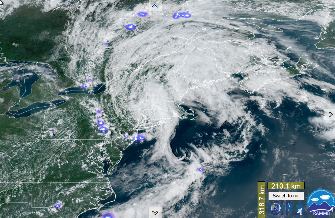
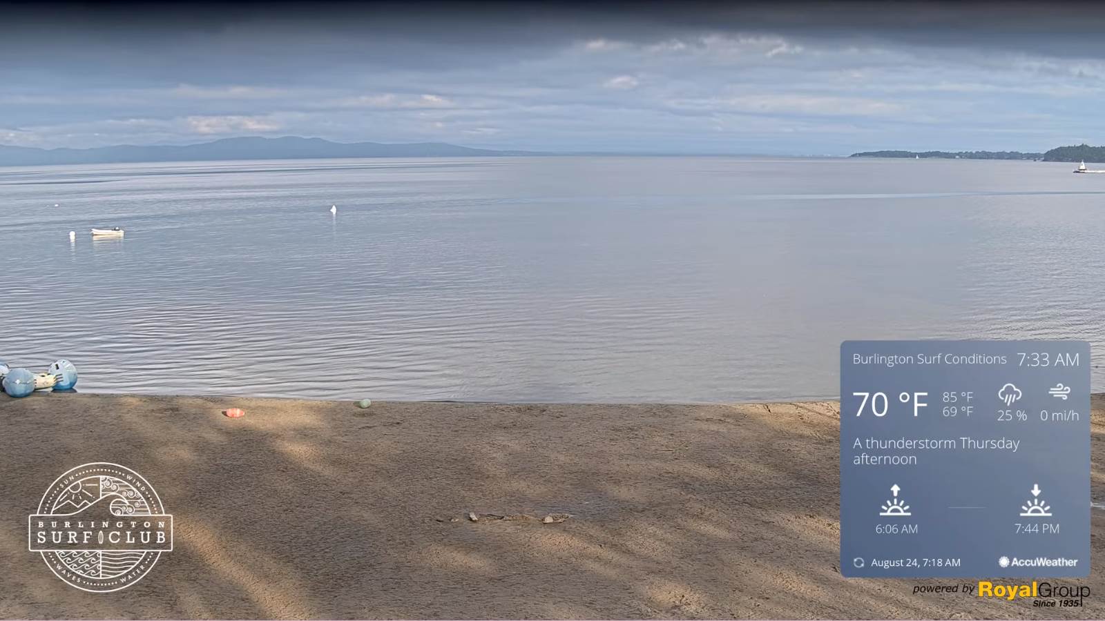
TODAY: A few cloudy periods early, then mixed sun and clouds. Isolated afternoon showers. A high 80 to 85. Northwest winds 10 mph.

TONIGHT: Mostly clear & moonlit. Patchy valley fog. A low in the lower 60s. Light northwest winds.

WEDNESDAY: Partly to mostly sunny. Hazy/smoky and very humid. A high mid-80s. Light southwest winds.

Looking further ahead…

WEDNESDAY NIGHT: Mostly clear and partially moonlit with more clouds toward daybreak…and slight chance for a thunderstorm northwestern areas. A low mid to upper 60s.

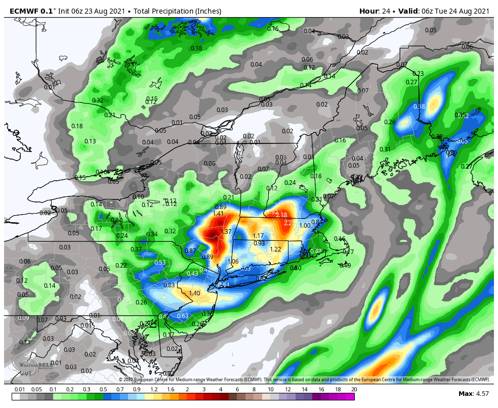
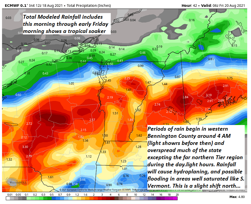
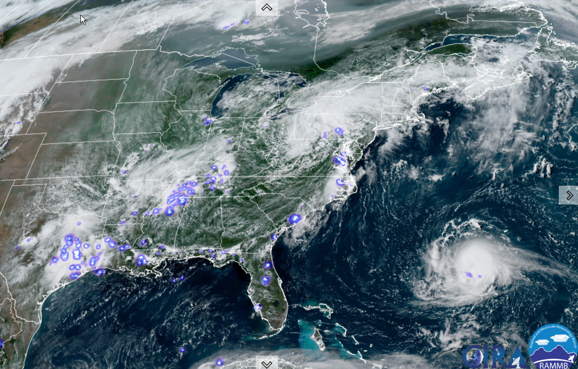
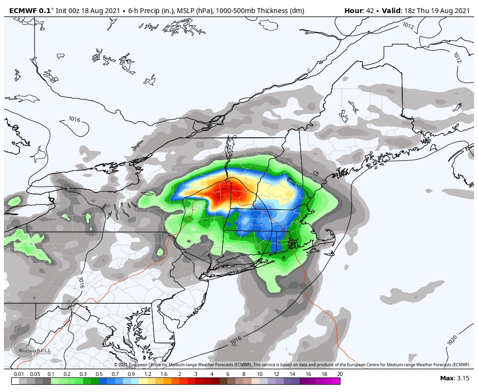
THURSDAY: Morning clouds. Slight chance for a thunderstorm northern Champlain Valley…otherwise becoming mostly sunny. Warm and sticky. Widely scattered afternoon showers and thunderstorms some possibly strong. A high in the mid to upper 80s.

FRIDAY: Partly sunny. A low 60 to 65. A high in the mid-70s.

SATURDAY: Mostly cloudy. Chance for showers in the afternoon. A low around 55. A high 65 to 70.

SUNDAY: Chance for showers…moderate at times early, then mixed sun and clouds. A low in the low 60s. A high around 70.

MONDAY: Partly to mostly cloudy. Scattered showers, maybe a thunderstorm. A low 55 to 60. A high in the 70s.

Average low 50 to 55. Average highs around 75.

RH/8-23forecast][end]

Updated Monday Evening Forecast — August 23rd, 2021

TONIGHT: Showers across southern areas this evening eventually drying up. Otherwise, partly to mostly cloudy for time this evening, giving way to moonlit skies overnight. Patchy valley fog. A low 60 to 65. Light east winds.

TOMORROW: A few cloudy periods early, then becoming mixed sun and clouds. Isolated afternoon showers. A high 80 to 85. Northwest winds 10 mph.

TUESDAY NIGHT: Mostly clear & moonlit. Patchy valley fog. A low in the lower 60s. Light northwest winds.

WEDNESDAY: More sun than clouds. Warm & humid. A high mid-80s. Light southwest winds.

Looking further ahead…

WEDNESDAY NIGHT: A few clouds but otherwise partially moonlit. A low mid to upper 60s.

THURSDAY: Mostly sunny. Warm and sticky. Isolated afternoon showers and thunderstorms. A high around 85.

FRIDAY: Partly sunny. A low 60 to 65. A high in the mid-70s

SATURDAY: Mostly cloudy. A low around 55. A high in the mid-70s.

Average low 50 to 55. Average highs around 75

RH/8-23forecast][end]

Updated Monday morning forecast — August 23rd, 2021

TODAY: Clouds with intervals of sunshine this morning. More clouds this afternoon with showers becoming likely across southern areas. A high mid to upper 70s. East breeze 10 mph.

TONIGHT: Clouds giving way to partially moonlit skies overnight. Patchy valley fog. A low in the low to mid 60s. Light east to northeast winds.

TUESDAY: A few morning clouds areas of fog, then becoming partly to mostly sunny. Widely scattered afternoon showers and isolated thunderstorms. A high in the lower 80s. Northwest winds 10 mph.

Looking further ahead…

TUESDAY NIGHT: Mostly clear & moonlit early, then more clouds overnight. A low in the lower 60s.

WEDNESDAY: Partly to mostly sunny. Warm & humid. A high mid to upper 80s.

THURSDAY: Warm and sticky. Scattered afternoon and evening showers and thunderstorms, some possibly strong. A low upper 60s to around 70. A high 80 to 85.

FRIDAY: Partly sunny. A low in the upper 50s to low 60s. A high 70 to 75.

Average low 50 to 55. Average highs around 75

RH/8-23forecast][end]

Updated Friday Evening Forecast — August 20th, 2021

TONIGHT: Partly cloudy with more cloudiness southern areas. Patchy valley fog. Continued muggy. A low around 65. Little wind.

TOMORROW: Clouds mixed with intervals of sun. Widely scattered afternoon showers and isolated thunderstorms. A high 80 to 85. Light southeast winds.

SATURDAY NIGHT: Partly to mostly cloudy. Stiflingly humid. A low around 70. Light east breeze.

SUNDAY: Clouds a few breaks of sun. Isolated showers northern areas, with a chance for rain or showers moderate to heavy at times southern Green Mountains, maybe a thunderstorm. A high around 80. East to northeast winds 10 to 15 mph.

Looking further ahead…

SUNDAY NIGHT: Mostly cloudy. Chance for showers toward southern areas…some moderate to heavy. A low about 70.

MONDAY: Clouds some breaks of sun. Scattered showers maybe a thunderstorm. A high near 80.

TUESDAY: Mixed clouds and sunshine. Scattered showers and isolated thunderstorms. A low 65 to 70. A high in the lower 80s.

WEDNESDAY: Partly to mostly sunny. Warm not quite so humid. A low in the lower 60s. A high 80 to 85.

Average low ranging thru the 50s. Average highs mid to upper 70s.

Warmest surface water temperatures peaking based off local lake climatology.

RH/8-20forecast][end]

Updated Friday Morning Forecast — August 20th, 2021

TODAY: Clouds mixing with intervals of sun after morning fog. Warm and sticky with a high around 80. Light northwest winds.

TONIGHT: Mostly cloudy but dry. Patchy valley fog. Continued muggy. A low around 65. Little wind.

SATURDAY: Mostly cloudy. Widely scattered afternoon showers and isolated thunderstorms. A high 80 to 85. Light southeast winds.

Looking further ahead…

SATURDAY NIGHT: Isolated showers and thunderstorms early, then just mostly cloudy. Stiflingly humid. A low around 70.

SUNDAY: Clouds a few breaks of sun. Scattered showers and a few afternoon thunderstorms mainly southern areas. A high around 80.

MONDAY: Gray. Chance for showers…some moderate to heavy at times with a rumble of thunder eastern & southern areas. A low around 65. A high 70 to 75.

TUESDAY: Mixed clouds and sunshine. Scattered showers and isolated thunderstorms. A low around 65. A high 80 to 85.

Average low ranging thru the 50s. Average highs mid to upper 70s.

Warmest surface water temperatures peaking based off local lake climatology.

RH/8-20forecast][end]

Updated Thursday Evening Forecast — August 19th, 2021

TONIGHT: Showers drying up later this evening. Otherwise cloudy & damp with considerable areas of fog. A low near 65. North to northwest winds 10 mph, stronger near Lake Champlain.

TOMORROW: Clouds mixed with breaks of sun after morning fog. Warmer and sticky. A high around 80. Light northwest winds.

FRIDAY NIGHT: Mostly cloudy but dry. Patchy valley fog. Continued muggy. A low around 65. Little wind.

SATURDAY: Mostly cloudy. Chance for afternoon showers and isolated thunderstorms. A high in the low 80s. Light southeast winds.

Looking further ahead…

SATURDAY NIGHT: Isolated showers and thunderstorms early, then just mostly cloudy. A low mid to upper 60s

SUNDAY: Clouds a few breaks of sun. Scattered showers and afternoon thunderstorms southern areas. A high upper 70s.

MONDAY: Gray. Chance for showers…some moderate to heavy at times with a rumble of thunder eastern areas. A low 60 to 65. A high mid-70s.

TUESDAY: Mixed clouds and sunshine. Scattered showers and isolated thunderstorms. A low around 65. A high around 80.

Average low ranging thru the 50s. Average highs mid to upper 70s.

Warmest surface water temperatures peaking based off local lake climatology.

RH/8-19forecast][end]

Updated Thursday Morning forecast — August 19th, 2021

Flash Flood Watch into the evening Addison-Washington-Orange county south

TODAY: Gray. Periods of rain, becoming moderate to heavy at times mid to late morning on. Maybe a rumble of thunder southern areas. Continued very humid. A high 70 to 75. Easterly breeze 10 mph, shifting to northerly late

TONIGHT: Periods of rain moderate to heavy at times with a rumble of thunder eastern areas this evening. Rain exits after midnight. Otherwise cloudy with areas of fog. A low near 65. North to northwest winds 10 mph, stronger near Lake Champlain.

FRIDAY: Clouds mixed with intervals of sunshine after morning fog. Warmer and stiflingly humid. A high in the low 80s. Light northwest winds.

Looking further ahead…

FRIDAY NIGHT: Mostly cloudy but dry. Patchy valley fog. Continued muggy. A low around 65.

SATURDAY: Clouds mixing with a few breaks of sunshine. Chance for afternoon showers and isolated thunderstorms. A high in the mid-80s.

SUNDAY: Clouds a few breaks of sun. Scattered showers and afternoon thunderstorms southern areas. A low mid to upper 60s

A high 75 to 80.

MONDAY: Partly sunny. Isolated afternoon showers or thunderstorms. A low 60 to 65. A high near 80.

TUESDAY: Mixed clouds and sunshine. Scattered showers and isolated thunderstorms. A low around 65. A high around 80.

Average low ranging thru the 50s. Average highs mid to upper 70s.

Warmest surface water temperatures peaking based off local lake climatology.

RH/8-19forecast][end]

Updated Wednesday Evening Forecast — August 18th, 2021

Flash Flood Watch 11 PM tonight thru Thursday evening for the southern ½ of the state.

TONIGHT: Cloudy. Isolated light showers or sprinkles…more numerous & moderate to heavy at times developing across southern Vermont overnight. Humid. A low mid to upper 60s. Light south to southeast winds.

TOMORROW: Gray. Periods of rain, becoming moderate to heavy at times mid to late morning on. Maybe a rumble of thunder late. Continued very humid. A high in the 70s. Easterly breeze 10 mph, shifting to northerly late

THURSDAY NIGHT: Periods of rain moderate to heavy at times with a rumble of thunder around midnight. Otherwise cloudy with areas of fog. A low near 65. North to northwest winds 10 mph.

FRIDAY: Clouds mixed with intervals of sunshine after morning fog. Warmer and stiflingly humid. A high 80 to 85. Light northwest winds.

Looking further ahead…

FRIDAY NIGHT: Mostly cloudy but dry. Patchy valley fog. Continued muggy. A low 65 to 70.

SATURDAY: Clouds mixing with a few breaks of sunshine. Chance for late afternoon showers and few thunderstorms mainly southern areas. A high 80 to 85.

SUNDAY: Clouds a few breaks of sun. Scattered showers and afternoon thunderstorms southern areas. A low around 65.

A high 75 to 80.

MONDAY: Partly sunny. A low near 60. A high 75 to 80.

Average low ranging thru the 50s. Average highs mid to upper 70s.

Warmest surface water temperatures peaking based off local lake climatology.

RH/8-18forecast][end]

Updated Wednesday Morning forecast — August 18th, 2021

TODAY: Lots of clouds. An occasional shower or sprinkle. Sticky. A high mid to upper 70s. Light southwest winds.

TONIGHT: Mostly cloudy. Isolated light showers…more numerous & moderate to heavy at times southern Vermont overnight. Humid. A low mid to upper 60s. Light south winds.

THURSDAY: Gray. Periods of rain, moderate to heavy at times of the Barre-Montpelier area south. Widely scattered showers northern areas. Continued very humid. A high in the 70s. East to southeast breeze 10 mph.

Looking further ahead…

THURSDAY NIGHT: Lots of clouds. Showers southeastern Vermont moderate at times, otherwise drying out northern western areas overnight with considerable valley fog. A low near 65.

FRIDAY: Considerable high cloudiness after morning fog. Warmer and stiflingly humid. A high 80 to 85.

SATURDAY: More clouds than sun. Chance for showers, maybe an afternoon thunderstorm southern areas. A low 65 to 70. A high 80 to 85.

SUNDAY: More clouds than sunshine. Scattered showers and afternoon thunderstorms southern areas. A low around 65. A high 75 to 80.

MONDAY: Variable cloudiness. A low near 60. A high 75 to 80.

Average low ranging thru the 50s. Average highs mid to upper 70s.

Warmest surface water temperatures peaking based off local lake climatology.

RH/8-17forecast][end]

Updated Tuesday Evening Forecast — August 17th, 2021

TONIGHT: Cloudy. Occasional sprinkles or passing showers. Patchy valley fog. A low near 65. Light south breeze stronger near Lake Champlain.

TOMORROW: Lots of clouds. An occasional shower or sprinkle. Sticky. A high mid to upper 70s. Light southwest winds.

WEDNESDAY NIGHT: Mostly cloudy. Isolated light showers…more numerous southern Vermont overnight. Humid. A low mid to upper 60s. Light south winds.

THURSDAY: Gray. Showers, moderate to heavy at times late. Isolated showers north. Continued very humid. A high mid to upper 70s. East to southeast breeze 10 mph.

Looking further ahead…

THURSDAY NIGHT: Lots of clouds. Showers eastern areas moderate at times, otherwise drying out northern western areas. A low 65 to 70.

FRIDAY: Lot clouds. Chance for showers. Isolated thunderstorms. Stiflingly humid. A high 80 to 85.

SATURDAY: Mostly cloudy. Chance for showers, maybe an afternoon thunderstorm. A low 65 to 70. A high near 85

SUNDAY: More clouds than sunshine. Scattered showers and afternoon thunderstorms. A low upper 60s to near 70. A high 75 to 80.

Average low mid to upper 50s. Average highs mid to upper 70s.

Warmest surface water temperatures peaking based off local lake climatology.

RH/8-17forecast][end]