My Updated Tuesday Night Forecast — September 2nd, 2025

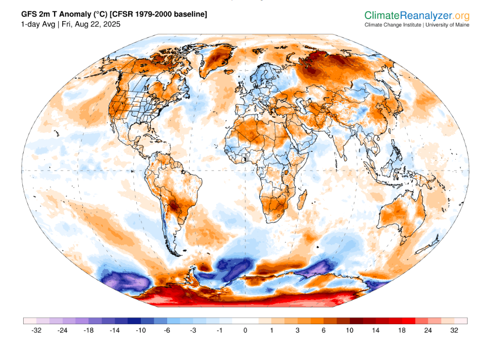
Roger Hill’s Radio Vermont Forecast 3:00 PM TUESDAY 9-2-25

TONIGHT: Mostly clear. Patchy valley fog. A low in the lower 50s. Light south winds.

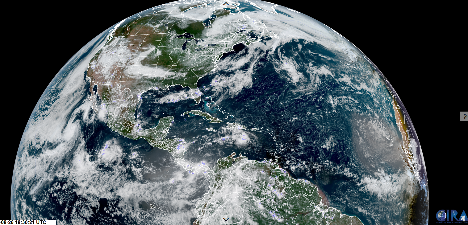
TOMORROW: Sunshine after valley fog, more clouds in the afternoon. A few pop-up late afternoon showers & thunderstorms around the Quebec border. A high around 75. Light south to southwest winds.

WEDNESDAY NIGHT: Clear. Isolated valley fog. A low in the lower 50s. Light south winds, stronger near Lake Champlain.

THURSDAY: Morning sun then mostly cloudy. Rising chance for late day showers. A bit muggy late. A high in the mid-70s. South breeze 10 to 20 mph stronger Champlain Valley.

Looking further ahead

THURSDAY NIGHT: Overcast. Showers likely, some moderate at times. A low in the upper 50s.

End of Meteorological Summer Friday (Warmest 90-day period)

FRIDAY: Widely scattered morning showers…taper offto partial sunshine. More humid. A high in the mid-70s.

SATURDAY: Clouding up. Chance for showers or periods of rain…possibly heavy, with a risk of thunder. Clammy. A low 60 to 65. Highs 65 to 70.

SUNDAY: Variable cloudiness/sunshine. Cooler & much drier. Lows 45 to 50. Highs around 65.

Average low: upper 40s to mid-50s. Average highs: 70 to 75

Full Harvest Moon 2:09 PM Sunday September 7th

Autumnal Equinox September 22nd.

Meteorological winter begins December 12th

RH/9-2/forecast][end]

My Updated Monday Night Forecast — September 1st, 2025

Roger Hill’s Radio Vermont Forecast 3:00 PM MONDAY LABOR DAY 9-1-25

TONIGHT: Fair with variable clouds. Patchy valley fog. A low around 55. Little wind.

TOMORROW: Morning sunshine mixing with more clouds. An isolated shower possible near the Quebec border late. A high in the mid-70s. Light south breeze.

TUESDAY NIGHT: Mostly clear. Patchy valley fog. A low in the lower 50s. Light south winds.

WEDNESDAY: Sunshine after valley fog, more clouds in the afternoon. Isolated late afternoon showers or thunderstorms northern areas. A high around 75. Light southwest winds.

Looking further ahead

WEDNESDAY NIGHT: Clear. Isolated valley fog. A low in the lower 50s.

THURSDAY: Partly to mostly sunny. Rising chance for late day showers into Thursday Night. A bit muggy late. A high in the mid to upper 70s.

End of Meteorological Summer

FRIDAY: Chance for early morning showers…tapering off in the afternoon to partial sunshine. A low upper 50s near 60. A bit humid. A high 70 to 75.

SATURDAY: Morning sun after valley fog…then lots of clouds. Chance for showers & possible afternoon thunderstorms. A low upper 50s near 60. Muggy. Highs 70s.

Average low: upper 40s to mid-50s. Average highs: 70 to 75

Full Harvest Moon 2:09 PM Sunday September 7th

Autumnal Equinox September 22nd.

Meteorological winter begins December 12th

RH/9-1/forecast][end]

My Updated Friday Night Forecast — August 29th, 2025

Roger Hill’s Radio Vermont Forecast 3:00 PM FRIDAY 8-29-25

TONIGHT: Partly cloudy & cool. Threat of a mountain sprinkle. A low in the mid-40s. Light west winds.

TOMORROW: Partly to mostly cloudy and unsettled. Scattered mainly afternoon showers northern areas. A high reaching the low to mid-60s. West breeze 10 mph.

SATURDAY NIGHT: Couple leftover showers winding down, otherwise some lingering clouds. Patchy valley fog. A low in the upper 40s. Light west winds.

SUNDAY: Morning fog, followed by partial sunshine. A high upper 60s about 70. Northwest winds 10 mph.

Looking further ahead

SUNDAY NIGHT: Clear & cool. Patchy valley fog. Lows 45 to 50.

MONDAY LABOR DAY: Morning sun then a few more afternoon clouds. Highs mid-70s.

TUESDAY: Partly sunny. Lows 50 to 55. Highs mid-70s.

WEDNESDAY: Partly to mostly sunny. Slight chance for an afternoon shower. A low mid to upper 50s. Highs mid-70s.

Average low: 50 to 55. Average highs: mid 70s.

End of Meteorological Summer September 5th

Full Harvest Moon 2:09 PM Sunday September 7th

RH/8-29/forecast][end]

My Updated Thursday Night Forecast — August 28th, 2025

Roger Hill’s Radio Vermont Forecast 3:00 PM THURSDAY 8-28-25

TONIGHT: Thickening clouds. Showers likely toward daybreak. A low around 55. Light south wind stronger near the lake.

TOMORROW: Showers, maybe a rumble of thunder…becoming isolated in the afternoon with partial sundeveloping.A high in the mid-60s. South winds 10 to 15 mph shifting to westerly in the afternoon.

FRIDAY NIGHT: Partly cloudy & cool. Threat of a mountain sprinkle. A low mid to upper 40s. Light west winds.

SATURDAY: Partly to mostly cloudy and unsettled. Scattered mainly afternoon showers with a possible rumble of thunder. A high reaching the mid-60s. West to northwest 10 to 15 mph.

Looking further ahead

SATURDAY NIGHT: A few clouds giving way to clear skies. A low mid-40s.

SUNDAY: Morning fog, followed by sunshine mixing with clouds. A high around 70.

MONDAY LABOR DAY: Partly to mostly sunny. Maybe a mountain sprinkle. Lows around 45. Highs around 75.

TUESDAY: Partly to mostly sunny. Lows 50 to 55. Highs mid-70s.

Average low: 50 to 55. Average highs: mid 70s.

End of Meteorological Summer September 5th

Full Harvest Moon 2:09 PM Sunday September 7th

RH/8-28/forecast][end]

My Updated Wednesday Night Forecast — August 27th, 2025

Roger Hill’s Radio Vermont Forecast 3:00 PM WEDNESDAY 8-27-25

TONIGHT: Mostly clear with high clouds overnight. Patchy valley fog. A low in the mid to upper 40s. Light southwest winds.

TOMORROW: Partly sunny & pleasant after valley fog. A high 70 to 75. South to southwest breeze 10 to 15 mph, stronger near Lake Champlain.

THURSDAY NIGHT: Thickening clouds. Rising chance for showers toward daybreak. A low 50 to 55. Light south wind.

FRIDAY: Showers likely in the morning, maybe a rumble of thunder…isolated in the afternoon with periods of sundeveloping.A high mid to upper 60s. South winds 10 to 15 mph shifting to westerly in the afternoon.

Looking further ahead

FRIDAY NIGHT: Cloudy periods & cool. Threat of a mountain sprinkle. Lows 45 to 50.

SATURDAY: Partly to mostly cloudy damp and unsettled. Scattered mainly afternoon showers and isolated thunderstorms northern ½ of the state. A high reaching the low to mid-60s.

SUNDAY: Morning fog, followed by sunshine mixing with clouds. A threat of a shower. A low mid-40s. A high upper 60s about 70.

MONDAY: More sun than clouds. Maybe a mountain sprinkle. Lows 45 to 50. Highs around 75.

Average low: 50 to 55. Average highs: mid 70s.

End of Meteorological Summer September 5th

Full Harvest Moon 2:09 PM Sunday September 7th

RH/8-27/forecast][end]

My Updated Tuesday Night Forecast — August 26th, 2025

Roger Hill’s Radio Vermont Forecast 3:00 PM TUESDAY 8-26-25

TONIGHT: Clear, with more clouds overnight, sprinkles possible western areas. A low mid to upper 40s. Light west winds.

TOMORROW: More sun than clouds. Good chance for showers, maybe a rumble of thunder. A high in the mid-60s. Northwest winds 10 mph.

WEDNESDAY NIGHT: Mostly clear. A low in the upper 40s. Light southwest winds.

THURSDAY: Morning sun becoming filtered with high clouds. A high 70 to 75. South to southwest winds 10 mph.

Looking further ahead

THURSDAY NIGHT: Thickening clouds. A low around 55.

FRIDAY: Variable cloudiness. Chance for showers, with rumbles of afternoon thunder. Highs mid to upper 60s.

SATURDAY: Partly to mostly cloudy. Widely scattered mainly afternoon showers and isolated thunderstorms. Lows 45 to 50. A high mid-60s.

SUNDAY: Morning fog, then partly sunny. A low mid to upper 40s. A high near 70.

Average low: 50 to 55. Average highs: mid 70s.

End of Meteorological Summer September 5th

Full Harvest Moon 2:09 PM Sunday September 7th

RH/8-25/forecast][end]

My Monday Night Forecast — August 25th, 2025

Roger Hill’s Radio Vermont Forecast 3:00 PM MONDAY 8-25-25

TONIGHT: Mostly clear this evening. More clouds overnight, maybe a shower northern border areas. A low 50 to 55. Light west winds.

TOMORROW: Clouds with intervals of sun. A sprinkle possible northern areas. A high in the upper 60s. Westerly breeze 10 to 15 mph.

TUESDAY NIGHT: Mostly clear, except clouds and a sprinkle western areas. A low near 45. Light west winds.

WEDNESDAY: Mixed sun and clouds. Chance for showers late morning on, maybe a rumble of thunder. A high 65 to 70. West to northwest winds 10 mph.

Looking further ahead

WEDNESDAY NIGHT: Mostly clear. A low in the mid-40s.

THURSDAY: Morning sun becoming filtered with high clouds. Highs in the low 70s.

FRIDAY: Considerable cloudiness. Chance for periods of rain or showers, with rumbles of thunder. Lows 50 to 55. Highs in the 60s.

SATURDAY: Partly to mostly cloudy. Widely scattered mainly afternoon showers and isolated thunderstorms. Lows 50s. Highs 60s

Average low: 50 to 55. Average highs: mid 70s.

End of Meteorological Summer September 5th

Full Harvest Moon 2:09 PM Sunday September 7th

RH/8-25/forecast][end]

My Updated Friday Night Forecast — August 22nd, 2025

Roger Hill’s Radio Vermont Forecast 3:00 PM FRIDAY 8-22-25

TONIGHT: Clear with a few high clouds overnight. A low around 55. Light south wind.

TOMORROW: Sunshine mixing with more afternoon clouds. Warm but comfortable. A high in the lower 80s. Southwest breeze picks up 10 to 15 mph, windy at the lake.

SATURDAY NIGHT: Mostly fair, clouding up overnight. Chance for showers & possible thunderstorms northwestern Vermont before day break. A low in the low 60s. South to southwest breeze 10 mph, stronger at the lake.

SUNDAY: Showers & thunderstorms likely…possibly some with heavy rainfall, otherwise mostly cloudy. A bit muggier. A high 70 to 75. South to southwest winds 10 to 15 mph, gusty Lake Champlain.

Looking further ahead

SUNDAY NIGHT: Lots of clouds. Good chance for showers, some possibly heavy…maybe a rumble of thunder. A low in the lower 60s.

MONDAY: Partly to mostly cloudy. Somewhat muggy. Scattered showers & possible afternoon thunderstorms, followed by late day clearing. Highs 70 to 75.

TUESDAY: More sun than clouds. Chance for a passing shower. Cooler with lowered humidity. Lows 50 to 55. A high around 65.

WEDNESDAY: Clouds with intervals of sun. On the cool side. Lows 45 to 50. Highs mid to upper 60s.

Average low: 50 to 55. Average highs: mid to upper 70s.

End of Meteorological Summer September 5th

Full Harvest Moon 2:09 PM Sunday September 7th

RH/8-20/forecast][end]

My Updated Thursday Night Forecast — August 21st, 2025

Roger Hill’s Radio Vermont Forecast 3:00 PM THURSDAY 8-21-25

TONIGHT: Clear and cool. A low upper 40s around 50. Light northeast winds.

TOMORROW: Sunshine with a few more afternoon clouds. A high near 80. North breeze 10 mph.

FRIDAY NIGHT: Mostly clear. A low around 55. Little wind.

SATURDAY: Partly to mostly sunny. A high in the lower 80s. Southwest breeze picks up 10 to 15 mph.

Looking further ahead

SATURDAY NIGHT: Mostly fair, clouding up overnight. Chance for showers possible thunderstorms northern areas by day break. A low around 60.

SUNDAY: A chance of showers, maybe a rumble of thunder early, otherwise partly to mostly cloudy. A little muggier. A low in the low 60s. with a high about 75.

MONDAY: Considerable clouds. Somewhat muggy. Scattered showers & possible afternoon thunderstorms, followed by late day clearing. Lows 60 to 65. Highs in the lower 70s.

TUESDAY: Intervals of sun then lots of clouds. Chance for more showers. Cooler & less muggy. Lows in the 50s. Highs in the 60s.

Average low: 50 to 55. Average highs: mid to upper 70s.

End of Meteorological Summer September 5th

Full Harvest Moon 2:09 PM Sunday September 7th

RH/8-20/forecast][end]

My Updated Wednesday Night Forecast — August 20th, 2025

Roger Hill’s Radio Vermont Forecast 3:00 PM WEDNESDAY 8-20-25

TONIGHT: Clear & chilly. A low mid to upper 40s. Little wind.

TOMORROW: Lots of sun with a more clouds late. Warming trend. A high about 75. Light east winds.

THURSDAY NIGHT: Clear and cool. A low upper 40s around 50. Light northeast winds.

FRIDAY: Sunshine with a few more afternoon clouds. A high upper 70s near 80. North breeze 10 mph.

Looking further ahead

FRIDAY NIGHT: Mostly clear. A low around 55.

SATURDAY: Sunny with afternoon clouds. A high in the lower 80s.

SUNDAY: Partly to mostly cloudy with a threat of a shower. Showers & possible thunderstorms pick up toward evening. A low in the low 60s. A little muggier with a highs about 75.

MONDAY: Mixed clouds and sun. Scattered showers, maybe an afternoon thunderstorm. Lows near 60. Highs near 75.

Average low: 50 to 55. Average highs: mid to upper 70s.

End of Meteorological Summer September 5th

Full Harvest Moon 2:09 PM Sunday September 7th

RH/8-20/forecast][end]