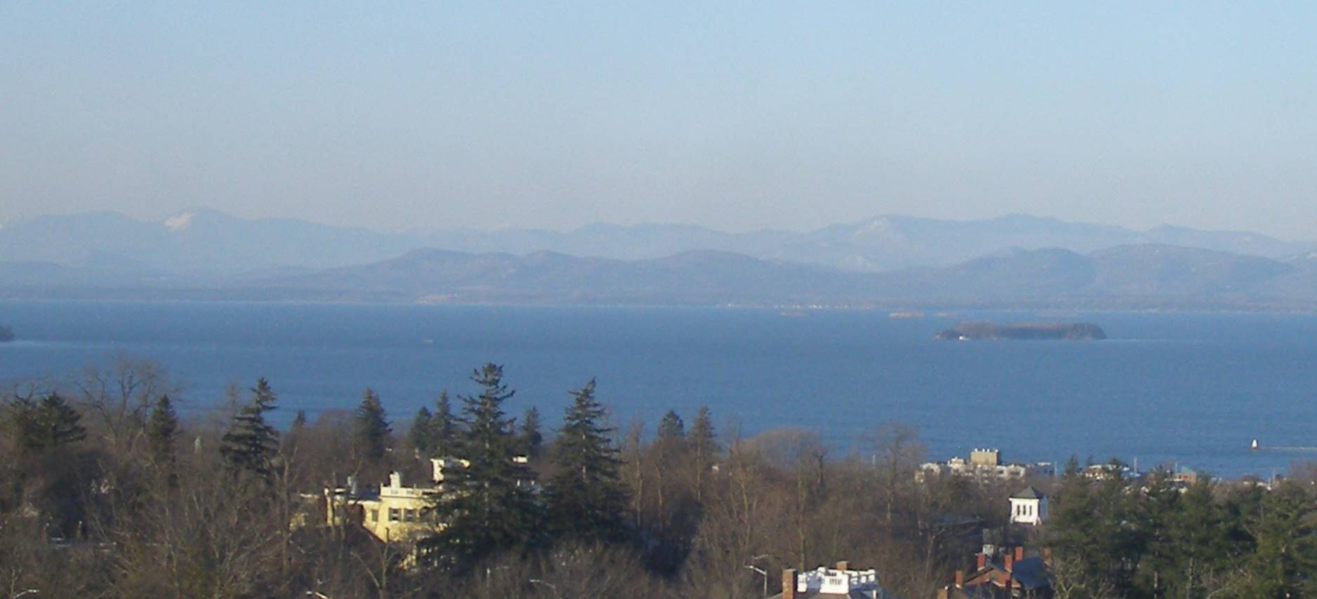
Milder trends ahead but also more cloudiness and occasionally some rain showers, but not today. Early morning travelers could find some icy spots east of the Green Mountains Sunday early morning. Warmth peaks around Tuesday next week.

TONIGHT: Becoming mostly clear and partially moonlit. Becoming partly cloudy late. A low in the single digits. Northwest winds 10 to 15 mph falling off overnight.
TOMORROW: Sunshine mixing with afternoon cloudy periods. A high in the upper 30s. Southwest winds 10 mph.
FRIDAY NIGHT: Clear skies giving way to a few clouds overnight.A low 25 to 30. South winds 10 mph, except stronger near the lake.
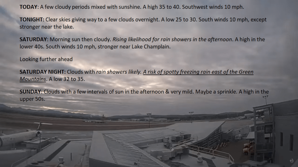
SATURDAY: Morning sun then cloudy. Rising likelihood for rain showers in the afternoon. A high 45 to 50. South winds 10 mph, stronger near Lake Champlain.
Looking further ahead
SATURDAY NIGHT: Clouds with rain showers likely.A low 32 to 35.
SUNDAY: Lots of clouds. Widely scattered rain showers. A high around 55.
MONDAY: Mainly gray. Chance for a few rain showers. A low in the mid to upper 30s. A high in the mid-50s.
TUESDAY: Clouds with a few breaks of sun. A low around 35. A high 55 to 60.
WEDNESDAY: Continued gray. Chance for rain showers. A low in the 40s. A high around 50.
Average lows upper-single digits to upper-teens. Average highs mid to upper 30s.
RH/2-29forecast][end]
TODAY: Partly to mostly sunny with more clouds this afternoon. Blustery to windy & colder. A high about 20. Northwest winds 10 to 25 mph with higher gusts near the mountains.
TONIGHT: Mostly clear and partially moonlit. Becoming partly cloudy late. A low 5 to 10 above. Northwest winds 10 to 20 mph falling off overnight. Light west to southwest winds.
FRIDAY: Sunshine mixing with afternoon cloudy periods. A high upper 30s to about 40. South to southwest winds 10 mph.
Looking further ahead
FRIDAY NIGHT: Clear skies giving way to a few clouds overnight.A low 25 to 30.

SATURDAY: Morning sun then cloudy. Rising chance for rain showers. A high in the mid-40s.
SUNDAY: Lots of clouds. Widely scattered rain showers. A low around 32 degrees with a high in the mid-50s.
MONDAY: Mainly gray. Chance for a few rain showers. A low in the mid to upper 30s. A high 50 to 55.

Average lows upper-single digits to upper-teens. Average highs mid to upper 30s.
RH/2-29forecast][end]


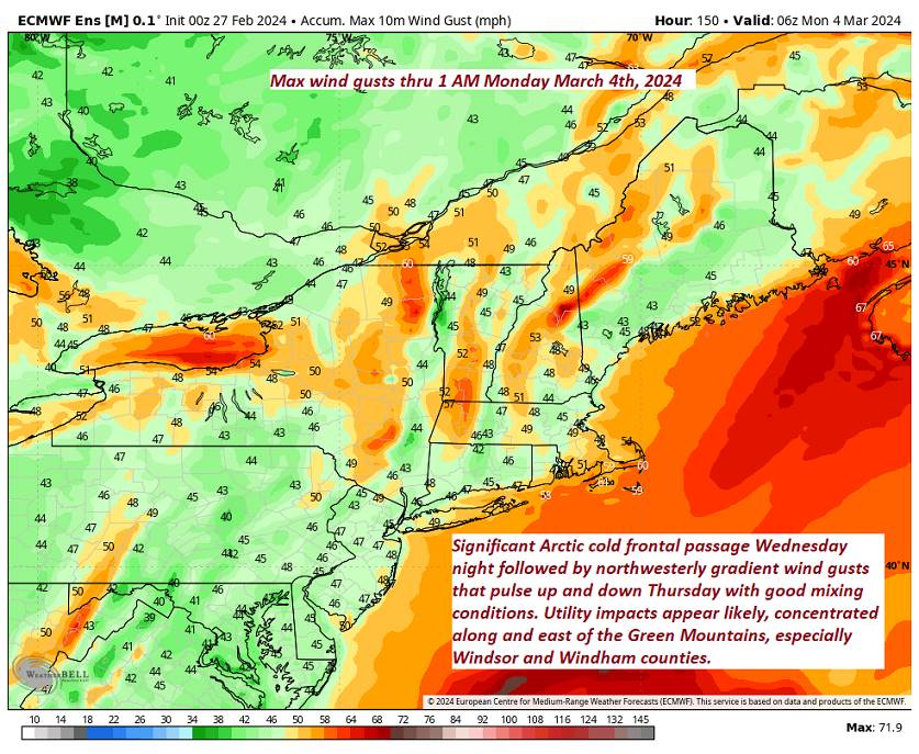
A Flood Watch and Wind Advisory into Thursday morning…
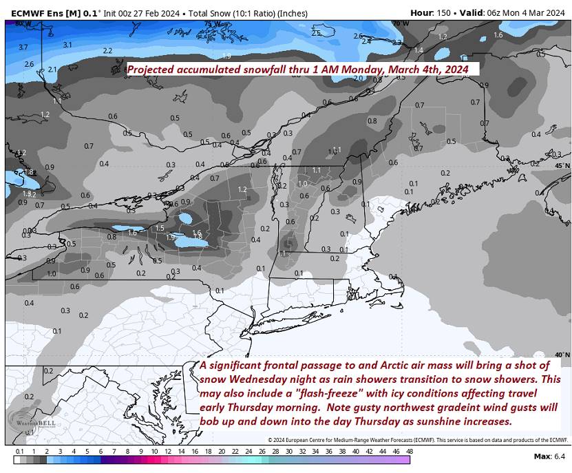
TONIGHT: Overcast.Rain…moderate at times early, changing to snow this evening, with up to an inch of accumulation. Blustery to windy with falling temperatures. A low upper single digits to mid-teens with icy slick overnight. Winds shifting to northwesterly and increasing to 10 to 25 mph with gusts exceeding 40 mph east of the Green Mountains.
TOMORROW: More sun than clouds, blustery to windy & colder. A high about 20. Northwest winds 10 to 25 mph with higher gusts near the mountains.
THURSDAY NIGHT: Mostly clear and partially moonlit. More clouds late. A low around 10. Northwest winds 10 to 20 mph falling off overnight. Light west to southwest winds.
FRIDAY: Sunshine mixing with afternoon cloudy periods. A high about 40. South to southwest winds 10 mph.
Looking further ahead
FRIDAY NIGHT: Clear skies giving way to a few clouds overnight.A low 25 to 30.
SATURDAY: Morning sun then thickening clouds. Rising chance for rain showers. A high around 50.
SUNDAY: Lots of clouds. Widely scattered rain showers. A low 30 to 35 with a high 50 to 55.
MONDAY: Mainly gray. Chance for a few rain showers. A low 40 to 45. A high around 55.

Average lows upper-single digits to upper-teens. Average highs mid to upper 30s.
RH/2-28forecast][end]
A Flood Watch and Wind Advisory 1 PM into Thursday morning…
TODAY: Cloudy & very mild. Occasional rain showers redevelops late this morning. Rising streams and rivers mainly due snow melt. A high in the low to mid 50s. Southeast winds 10 to 15 mph.
TONIGHT: Overcast.Rain…moderate at times…changing to snow late evening, with up to an inch of accumulation. Blustery to windy. An eventual low ranging upper single digits to mid-teens toward daybreak with icy slick travel on untreated roads. South winds shifting to northwesterly and increasing to 10 to 25 mph with higher gusts east of the Green Mountains
THURSDAY: More sun than clouds, blustery to windy & colder. A high about 20. Northwest winds 10 to 25 mph with higher gusts near the mountains.
Looking further ahead
THURSDAY NIGHT: Mostly clear and partially moonlit. More clouds late. A low around 10.
FRIDAY: Cloudiness gives way to partial sun, but with a stray mountain flurry or two. A high about 40.
SATURDAY: Morning sun then more clouds. Rising chance for a rain shower. A low 25 to 30. A high around 50.
SUNDAY: Lots of clouds. Chance for a few rain showers. A low 30 to 35 with a high 50 to 55.
Average lows upper-single digits to upper-teens. Average highs mid to upper 30s.
RH/2-28forecast][end]
TONIGHT: Thickening clouds.Scattered rain showers developing later this evening exiting before daybreak.A low near 40.South breeze 10 mph.
TOMORROW: Mainly gray. Occasional rain showers late morning on. Rising streams and rivers due to snow melt. A high in the low 50s. Southeast winds 10 to 15 mph.
WEDNESDAY NIGHT: Overcast.Rain showers likely moderate at times…changing to snow showers, with up to an inch of accumulation. Blustery to windy. An eventual low ranging 5 to 15 by daybreak with icy spots and slick travel. South winds shifting to northwesterly and increasing to 10 to 25 mph with higher gusts east of the Green Mountains
THURSDAY: More sun than clouds, blustery to windy & colder. A high in the low 20s. Northwest winds 10 to 25 mph with higher gusts near the mountains.
Looking further ahead
THURSDAY NIGHT: Mostly clear and partially moonlit. More clouds late. A low ranging near zero far north, to around 15 above western Vermont valleys.
FRIDAY: Cloudiness gives way to partial afternoon sun. A high in the lower 40s.
SATURDAY: Lots of sunshine and a beauty. A low upper 20s. A high around 50.
SUNDAY: Mostly sunny. A low near 32 with a high mid to upper 50s.
Average lows upper-single digits to upper-teens. Average highs mid to upper 30s.
RH/2-26forecast][end]
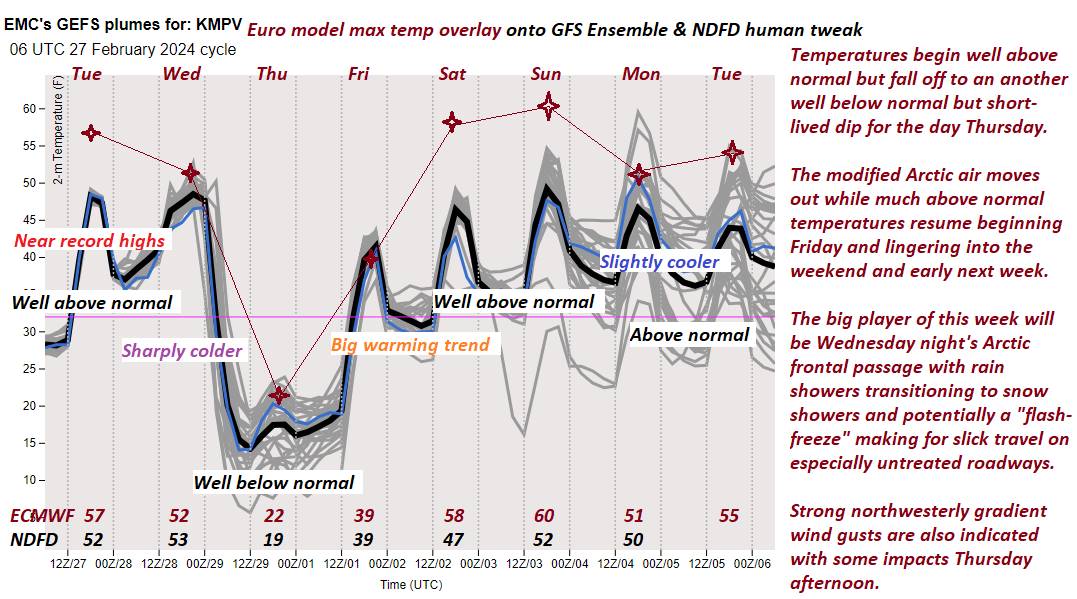
TODAY: Pick of the week. Lots of sunshine, mild and spring-like.Increasing snow melt.A high near record high 55 to 60.Southeast winds 10 to occasionally 20 mph.
TONIGHT: Thickening clouds.Scattered rain showers.A low upper 30s to around 40.South breeze 10 mph.
WEDNESDAY: Mainly gray. Occasional rain showers late morning on. Rising streams and rivers due to snow melt. A high near 50. Southeast winds 10 to 15 mph.
Looking further ahead
WEDNESDAY NIGHT: Overcast.Rain showers likely moderate at times…changing to snow showers, with up to an inch of accumulation. Blustery to windy. An eventual low ranging 5 to 15 by daybreak with icy spots and slick travel. South winds shifting to northwesterly 10 to 25 mph with higher gusts east of the Green Mountains
THURSDAY: More sun than clouds, blustery to windy & colder. A high 20 to 25. Gusty northwesterly winds.
FRIDAY: Cloudiness gives way to partial afternoon sun. A morning low 5 to 15. A high in the lower 40s.
SATURDAY: Lots of sunshine and a beauty. A low upper 20s. A high around 50.
SUNDAY: Mostly sunny. A low near 32 with a high mid to upper 50s.
Average lows upper-single digits to upper-teens. Average highs mid to upper 30s.
RH/2-26forecast][end]
TONIGHT: Becoming mostly clear and moonlit with some high cloudiness.A low in the mid-20s. Light southeast winds.
TOMORROW: Lots of sunshine, mild and spring-like.A high pushing to near 55.Southeast winds 10 to occasionally 20 mph.
TUESDAY NIGHT: Clouding up.Rain showers likely in the evening.A low around 40.South breeze 10 mph.
WEDNESDAY: Mainly gray. Scattered rain showers late morning on. A high in the upper 40s to near 50. Southeast winds 10 to 15 mph.
Looking further ahead
WEDNESDAY NIGHT: Overcast.Rain showers likely moderate at times…changing to snow showers, with up to an inch of accumulation. Increasingly blustery to windy. A low 10 to 15. Gusty northwest winds developing.
THURSDAY: More sun than clouds, blustery to windy & colder. A high around 25. Gusty northwesterly winds.
FRIDAY: A few morning clouds, then mostly sunny. A low 10 to 15. A high rebounding to around 40.
SATURDAY: Sunshine gives way to increasing clouds. A low around 30. A high near 50.
Average lows upper-single digits to upper-teens. Average highs mid to upper 30s.
RH/2-26forecast][end]