
Be gentle and kind to our local wild life. The Spotted Salamanders are coming out after the last snows melt heading for ponds and looking for love.


TONIGHT: Fair and dry this evening, becoming partly to mostly cloudy & unsettled with showers arriving late.A low 35 to 40. Southeast winds 10 mph.
TOMORROW: Considerable clouds with scattered rain showers. Some partial clearing late afternoon. A high in the mid-50s. South to southeast winds 10 mph but stronger near Lake Champlain.
WEDNESDAY NIGHT: A couple leftover showers exit in the evening, otherwise lots of clouds.A low 40 to 45. Southeast winds 10 mph.
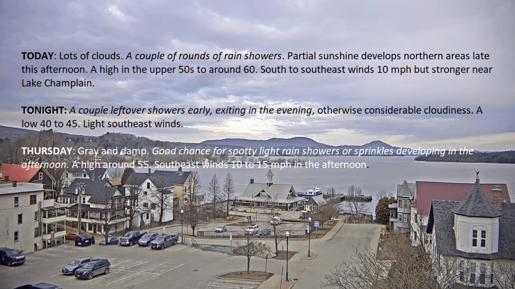
THURSDAY: Gray and damp. Good chance for spotty light rain showers or sprinkles developing in the afternoon. A high in the lower 50s. Southeast winds 10 mph.
Looking further ahead
THURSDAY NIGHT: Cloudy & breezy to windy. Scattered rain showers.A low upper 40s. Southeasterly winds 10 to 15 mph.
FRIDAY: Overcast & breezy to windy western slopes of the Green Mountains. Chance for rain showers, moderate at times, maybe a rumble or two of thunder. A high 55 to 60.
SATURDAY: Brief morning sun, then cloudy. Chance for rain showers mixed with wet snowflakes higher terrain. A low in the lower 40s. A high 45 to 50.

SUNDAY: Mixed sun and clouds. Maybe a mountain sprinkle. A low 35 to 40. A high 50 to 55.
Average lows mid-20s to low 30s. Average 50 to 55
Start of meteorological summer June 6th

RH/4-9forecast][end]
TODAY: Pick of the week. Sunshine becoming filtered thru high clouds later this afternoon. Comfortably mild. A high in the low to mid 60s. Light west winds.
TONIGHT: Fair and dry this evening, becoming partly to mostly cloudy & unsettled with a rising chance for a few showers arriving late.A low 35 to 40. Southeast winds 10 mph.
WEDNESDAY: Considerable clouds with scattered rain showers. Some partial clearing late afternoon. A high in the mid-50s. South to southeast winds 10 mph.
Looking further ahead
WEDNESDAY NIGHT: A couple leftover showers exit in the evening, otherwise lots of clouds.A low 40 to 45.
THURSDAY: Gray and damp. Good chance for spotty light rain showers or sprinkles. A high in the lower 50s.
FRIDAY: Overcast & breezy to windy western slopes of the Green Mountains. Chance for rain showers, moderate at times. A low upper 40s. A high 55 to 60. Gusty southeasterly winds.
SATURDAY: Brief morning sun, then cloudy. Chance for rain showers mixed with wet snowflakes higher terrain. A low in the lower 40s. A high 45 to 50.
SUNDAY: Mixed sun and clouds. Maybe a mountain sprinkle. A low 35 to 40. A high 50 to 55.
Average lows mid-20s to low 30s. Average 50 to 55
Start of meteorological summer June 6th
RH/4-9forecast][end]

TONIGHT: Partly cloudy. A low about 35. Light west winds.
TOMORROW: Sunshine filtered thru high clouds. Very mild. A high in the low to mid 60s. Light west winds.
TUESDAY NIGHT: Variable cloudiness and unsettled.A rising chance for a few showers arriving late.A low 35 to 40. Southeast winds 10 mph.

WEDNESDAY: Clouds with a few breaks of sun. Scattered rain showers. A high around 50. South to southeast winds 10 mph.
Looking further ahead
WEDNESDAY NIGHT: Cloudy.A couple leftover showers exit.A low 40 to 45.

THURSDAY: Gray and damp. Scattered rain showers. A high upper 40s to around 50.
FRIDAY: Clouds with a break or two of sun. Good chance for periods of rain or showers. A low upper 40s to around 50. A high around 60.
SATURDAY: Morning sun then lots of clouds. Chance for rain showers mixed with wet snow higher terrain late. A low in the lower 40s. A high 45 to 50.
Average lows mid-20s to low 30s. Average 50 to 55

Start of meteorological summer June 6th
RH/4-8forecast][end]

TODAY: Sunshine becoming filtered thru high clouds this afternoon. Arrival of this cirrus clouds…about 2:30 to 3:30 PM with the eclipse 3:26 PM. A high near 55. Light northwest winds.
TONIGHT: Partly to mostly cloudy. A low about 35. Light west winds.
TUESDAY: Sunshine filtered thru high clouds. A high around 60. Light northwest winds.
Looking further ahead
TUESDAY NIGHT: Variable cloudiness and unsettled.Slight chance for a shower.A low mid to upper 30s.
WEDNESDAY: Clouds with intervals of afternoon sunshine. Scattered light afternoon rain showers. A high around 50.
THURSDAY: Gray and damp. Good chance for periods of rain or rain showers. A low 40 to 45. A high upper 40s to around 50.
FRIDAY: Clouds with a break or two of sun. Good chance for periods of rain or showers. A low 45 to 50. A high 55 to 60.
SATURDAY: Morning sun then lots of clouds. Chance for rain showers mixed with wet snow higher terrain late. A low near 40. A high in the mid-40s.
Average lows mid-20s to low 30s. Average 50 to 55
Start of meteorological summer June 6th
RH/4-8forecast][end]
TONIGHT: Overcast. Scattered snow showers or flurries. A dusting to a half inch or so. A low about 30. Light northwest winds.
TOMORROW: Cloudy with a few breaks of sun away from the mountains late. Scattered leftover rain or wet snow showers. Little to no accumulation. A high in the upper 30s to near 40. North to northwest winds 10 to 20 mph.
SATURDAY NIGHT: Considerable lingering cloudiness with a few northern mountain flurries winding down.A low mid to upper 20s. A light north wind.
SUNDAY: Mainly gray, eventually giving way to periods of late afternoon sunshine. A high near 45. North winds 10 mph.
Looking further ahead
SUNDAY NIGHT: Clear and colder.A low in the upper teens to around 20.

MONDAY: Mostly sunny with some thin high clouds. Total Solar Eclipse 3:26 PM EDT. A high around 50.
TUESDAY: Sunshine filtered thru high clouds. A low 25 to 30. A high around 55.
WEDNESDAY: Partly sunny with more in the afternoon. Rising chance for scattered afternoon rain showers. A low around 25. A high in the 50s.
Average lows 25 to 30. Average highs 45 to 50.
Start of meteorological summer June 6th
RH/4-5forecast][end]
