Updated Friday Evening Forecast — June 7th, 2024

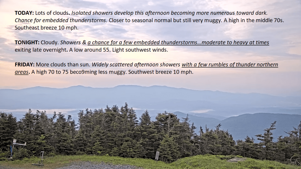
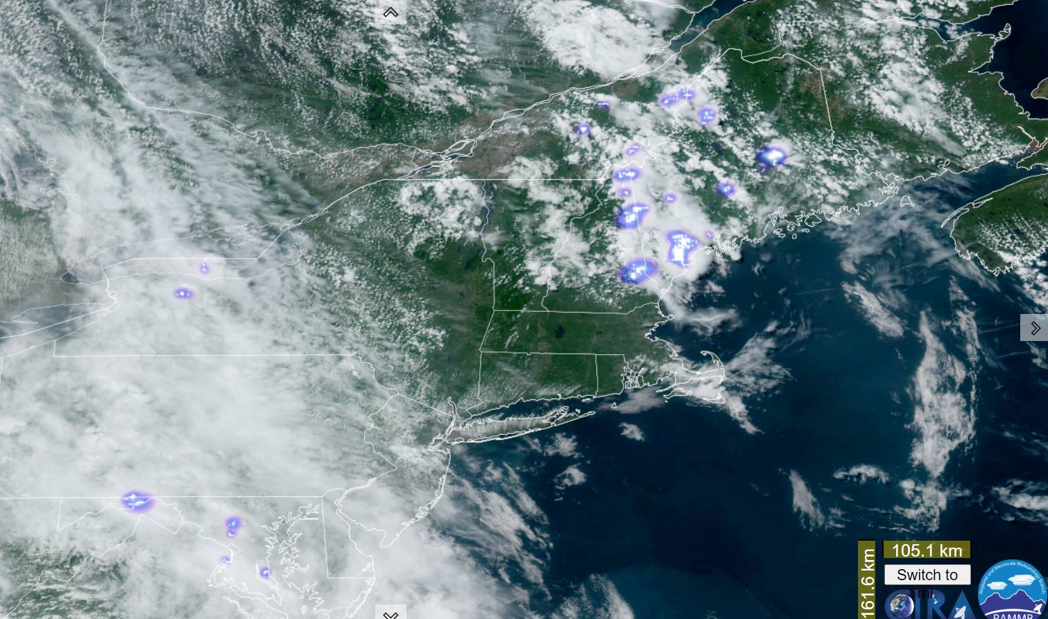
TONIGHT: Scattered showers with a rumble or two early, drying up by later this evening then partly cloudy. A low 50 to 55. Light southwest winds.

TOMORROW: Lots of clouds & breezy.Scattered afternoon showers with a rumble or two of thunder northern areas.A high mid to upper 60s. West breeze 10 to 15 mph.

SATURDAY NIGHT: Am isolated early evening shower, otherwise cloudy with few sprinkles late toward daybreak.A low in the low 50s. Light southwest winds.

SUNDAY: Chance for showers in the morning, becoming widely scattered later on. Intervals of sunshine. A high in the mid to upper 60s. Southwest winds 10 to 15 mph.

Looking further ahead

SUNDAY NIGHT: Scattered evening clouds, with a sprinkle. Clouding up after midnight. A low in the upper 40s.

MONDAY: Morning sun, then mostly cloudy. Scattered mountain sprinkles. A high around 65.

TUESDAY: Clouds with a few intervals of sunshine. Scattered mountain sprinkles. A low mid-50s. A high around 70.

WEDNESDAY: Partly to mostly cloudy. Maybe a mountain sprinkle. A low 50 to 55. A high around 75.

Average lows mid-40s to low 50s. Average highs 70 to 75.

RH/6-7forecast][end]

Updated Friday Morning Forecast — June 7th, 2024

TODAY: Dense morning fog burns off to a mix of sun and clouds.Scattered afternoon showers with a few thunderstorms especially Champlain Valley and northern tier. A high near 75, not so humid. Southwest breeze 10 mph.

TONIGHT: Mostly cloudy. Scattered showers drying up. A low in the lower 50s. Light southwest winds.

SATURDAY: Lots of clouds & breezy.Scattered afternoon showers with a rumble or two of thunder northern areas.A high in the upper 60s. West breeze 10 to 15 mph.

Looking further ahead

SATURDAY NIGHT: Scattered showers drying up early. Cloudy Chance for more showers arriving toward daybreak. A low 50 to 55.

SUNDAY: Partly to mostly cloudy & cool. Chance for showers. A high in the upper 60s.

MONDAY: Morning sun, then mostly cloudy. Scattered mountain sprinkles. A low around 50. A high around 65.

TUESDAY: Clouds with a few intervals of sunshine. Scattered mountain sprinkles. A low around 50. A high upper 60s.

WEDNESDAY: Partly to mostly cloudy. Maybe a mountain sprinkle. A low 50 to 55. A high low to mid 70s.

Average lows mid-40s to low 50s. Average highs 70 to 75.

RH/6-7forecast][end]

Updated Thursday Evening Forecast — June 6th, 2024

TONIGHT: Cloudy. A band of showers, some moderate to heavy at times with and embedded thunderstorm or two,exiting to partial clearing later overnight.A low around 60. Light south to southwest winds.

TOMORROW: Mixed sun and clouds.Scattered mainly afternoon showers with a rumble of thunder northern areas. A high near 75, not so humid. Southwest breeze 10 mph.

FRIDAY NIGHT: Mostly cloudy. Scattered showers drying up. A low in the lower 50s. Light southwest winds.

SATURDAY: Lots of clouds & breezy.Afternoon showers becoming likely.A high in the upper 60s. West breeze 10 to 15 mph.

Looking further ahead

SATURDAY NIGHT: Scattered showers drying up early. Cloudy Chance for more showers arriving toward daybreak. A low 50 to 55.

SUNDAY: Partly to mostly cloudy & cool. Chance for showers, maybe a rumble of afternoon thunder. A high in the upper 60s.

MONDAY: Morning sun, then mostly cloudy. Chance for a shower or two. A low around 50. A high around 65.

TUESDAY: Clouds mixed with some sun. Scattered light sprinkles. A low around 50. A high upper 60s.

Average lows mid-40s to low 50s. Average highs 70 to 75.

RH/6-5forecast][end]

Updated Thursday Morning Forecast — June 6th, 2024

TODAY: Lots of clouds. Isolated showers develop this afternoon becoming more numerous toward dark. Chance for embedded thunderstorms.Closer to seasonal normal but still very muggy. A high in the middle 70s. Southeast breeze 10 mph.

TONIGHT: Cloudy.Showers & a chance for a few embedded thunderstorms…moderate to heavy at times exiting late overnight. A low around 55. Light southwest winds.

FRIDAY: More clouds than sun.Widely scattered afternoon showers with a few rumbles of thunder northern areas. A high 70 to 75 becoming less muggy. Southwest breeze 10 mph.

Looking further ahead

FRIDAY NIGHT: Mostly cloudy. Scattered showers and isolated rumbles of thunder winding down. A low 50 to 55.

SATURDAY: Lots of clouds.Chance for showers, maybe a rumble of thunder.A high mid to upper 60s.

SUNDAY: Partly to mostly cloudy & cool. Chance for showers, maybe a rumble of thunder. A low 50 to 55. A high in the upper 60s.

MONDAY: Morning sun, then mostly cloudy. Chance for a shower or two. A low around 50. A high around 65.

TUESDAY: Clouds mixed with some sun. Scattered light sprinkles. A low around 50. A high upper 60s.

Average lows mid-40s to low 50s. Average highs 70 to 75.

RH/6-5forecast][end]

Updated Wednesday Evening Forecast — June 5th, 2024

TONIGHT: Becoming mostly cloudy. Isolated showers wind down early. A low around 60. Light southeast winds.

Start of meteorological summer

TOMORROW: Lots of clouds. Scattered showers develop in the afternoon. Embedded thunderstorms arriving toward evening.Cooler.A high in the mid-70s. Southeast breeze 10 to 15 mph.

THURSDAY NIGHT: Overcast.Showers & embedded heavier thunderstorms likely…exiting later overnight. A low 55 to 60. Light south winds.

FRIDAY: Lots of clouds.Widely scattered afternoon showers with a few rumbles of thunder. A high around 70. Light southwest winds.

Looking further ahead

FRIDAY NIGHT: Mostly cloudy. Scattered showers and isolated rumbles of thunder winding down. A low near 55.

SATURDAY: Considerable cloudiness.Chance for showers, some heavy and isolated rumbles of thunder.A high in the upper 60s near 70.

SUNDAY: Mostly cloudy damp and cool. Chance for showers. A low 50 to 55. A high mid to upper 60s.

MONDAY: Sunshine then mostly cloudy. Chance for showers and possible thunderstorms. A low 50 to 55. A high in the mid-60s.

Average lows mid-40s to low 50s. Average highs 70 to 75.

RH/6-5forecast][end]

Updated Wednesday morning Forecast — June 5th, 2024

TODAY: Partly sunny.Widely scattered mainly afternoon showers & thunderstorms…especially Northeast Kingdom/Connecticut Valleys. A high around 85. Light southwest winds.

TONIGHT: Becoming mostly cloudy. Any isolated showers wind down early. A low around 60. Light southeast winds.

Start of meteorological summer

THURSDAY: Lots of clouds. Scattered showers develop in the afternoon. Embedded thunderstorms arriving toward evening.Cooler.A high in the mid-70s. Southeast breeze 10 mph.

Looking further ahead

THURSDAY NIGHT: Overcast.Showers & embedded heavier thunderstorms likely…exiting later overnight. A low 55 to 60.

FRIDAY: Lots of clouds.Widely scattered afternoon showers with a few rumbles of thunder. A high around 70.

SATURDAY: Considerable cloudiness.Chance for showers, some heavy and isolated rumbles of thunder.A low near 55. A high in the upper 60s near 70.

SUNDAY: Mostly cloudy damp and cool. Chance for showers. A low 50 to 55. A high mid to upper 60s.

MONDAY: Sunshine then mostly cloudy. Chance for showers and possible thunderstorms. A low 50 to 55. A high in the mid-60s.

Average lows mid-40s to low 50s. Average highs 70 to 75.

RH/6-5forecast][end]