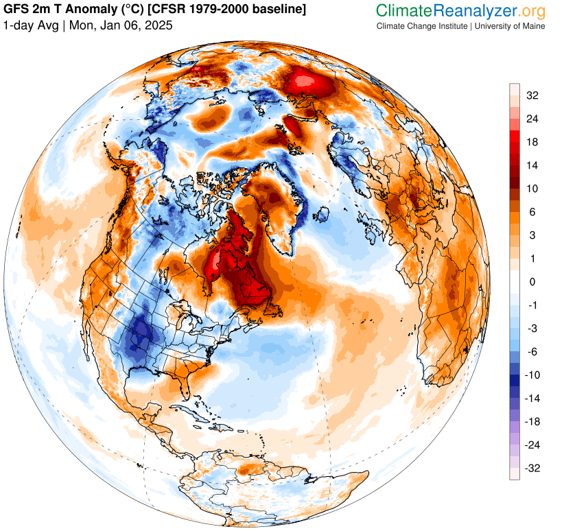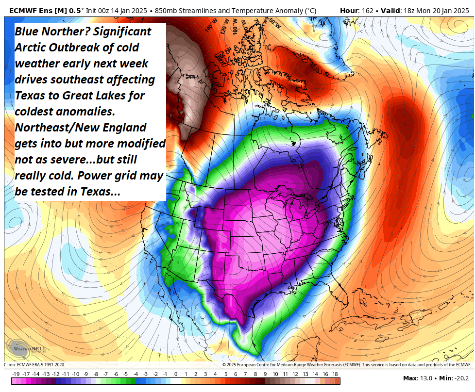
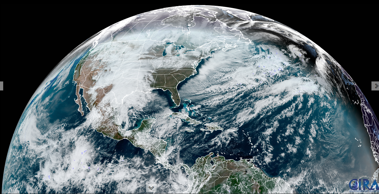
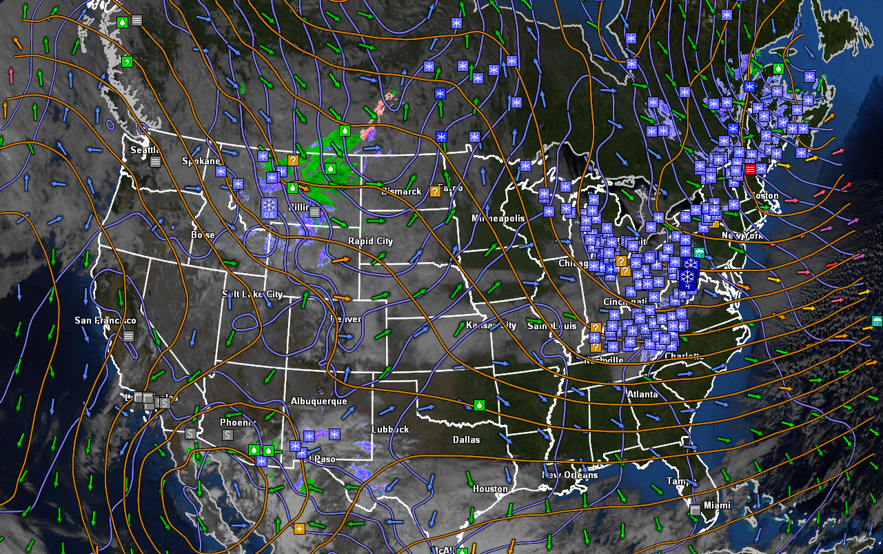
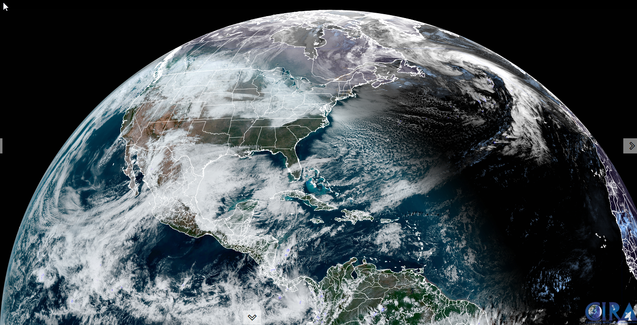
High latitude blocking forces arctic air southeast especially through the Rockies and Plains ending up in mid-section of the nation early next week. Shown – modelled for Monday Afternoon.

Full Wolf Moon at 5:27 PM
TONIGHT: Generally cloudy. Flurries or brief accumulating snow showers or squalls mainly north. A low 15 to 20. Light southwest winds.
TOMORROW: Gray. Chance for flurries northern areas. A high in the mid-20s. Westerly winds 10 to 15 mph.
TUESDAY NIGHT: Considerable clouds. Scattered accumulating snow showers or flurries. A low 10 to 15. Winds becoming northwesterly 10 to 15 mph.
WEDNESDAY: Clouds with stray early flurry, mixing with intervals of sun. Colder. A high in the low to mid-teens. Northwest winds 10 to 15 mph.
Looking further ahead
WEDNESDAY NIGHT: Becoming partly cloudy. A low ranging 5 below to 10 above.
THURSDAY: Mainly gray. Maybe a flurry. Warming trend. A high in the upper teens to low 20s.
FRIDAY: Cloudy.A low ranging near zero to 15 above. A high around 25.
SATURDAY: Overcast.Rising chance for light accumulating snow or flurries. A low in the mid-20s. A high about 35.
Average low ranging thru the single digits. Average high mid-20s to 30.
Peak Meteorological Winter 1-23-25
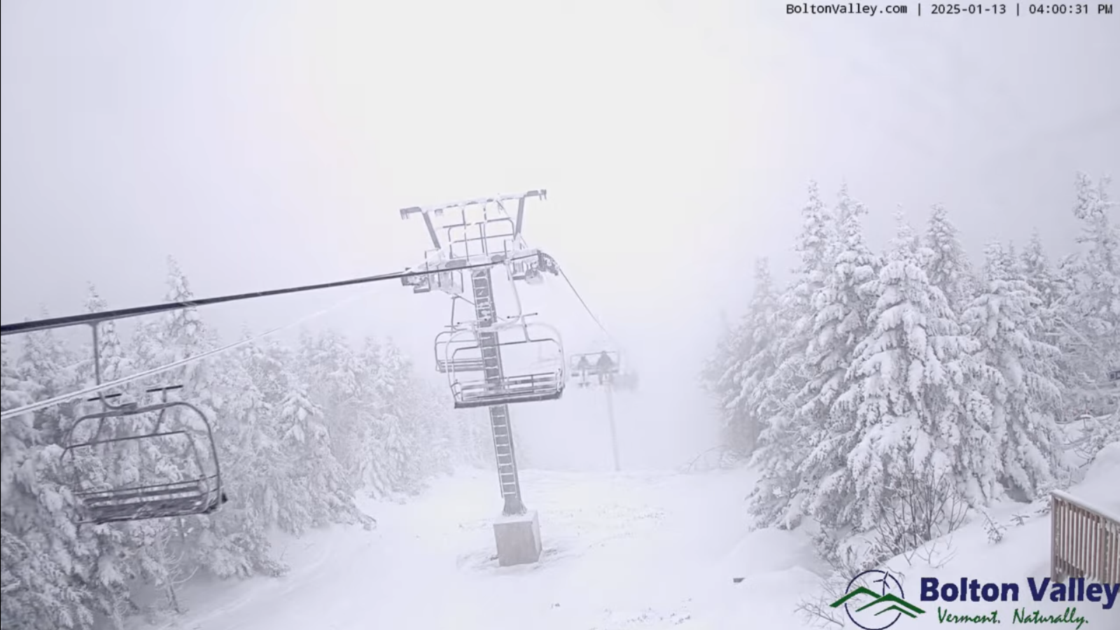
RH/1-13-25forecast][end]

TONIGHT: Thickening clouds…leading to light accumulating snow or flurries. A light coating late. A low ranging 5 to 15. Little wind.
TOMORROW: Gray. Periods of light snow or flurries winding down late. Accumulations of about 1 to 2”. A high lower 20s. Light southeast winds.
SATURDAY NIGHT: A lingering flurry northern areas with little accumulation, then becoming partly to mostly clear late. A low near 15. Light northwest winds.
SUNDAY: Morning clouds then partly mostly sunny in the afternoon. A high about 25. Light northwest winds.
Looking further ahead
SUNDAY NIGHT: Becoming mostly cloudy. Chance for northern flurries limited accumulation. A low 10 to 15

Full Wolf Moon Monday at 5:27 PM
MONDAY: Increasingly cloudy. Slight chance for additional flurries northern Vermont. Warmer with a high around 32 degrees.
TUESDAY: Clouds with intervals of sun. Chance for flurries northern areas. A low near 15. A high near 25.
WEDNESDAY: Maybe a break of sun otherwise lots of clouds. Scattered accumulating snow showers or flurries. Dusting to an inch or two especially northern areas. Lows around 15, a high near 20.

Average low ranging thru the single digits. Average high mid-20s to near 30.
Peak Meteorological Winter 1-23-25
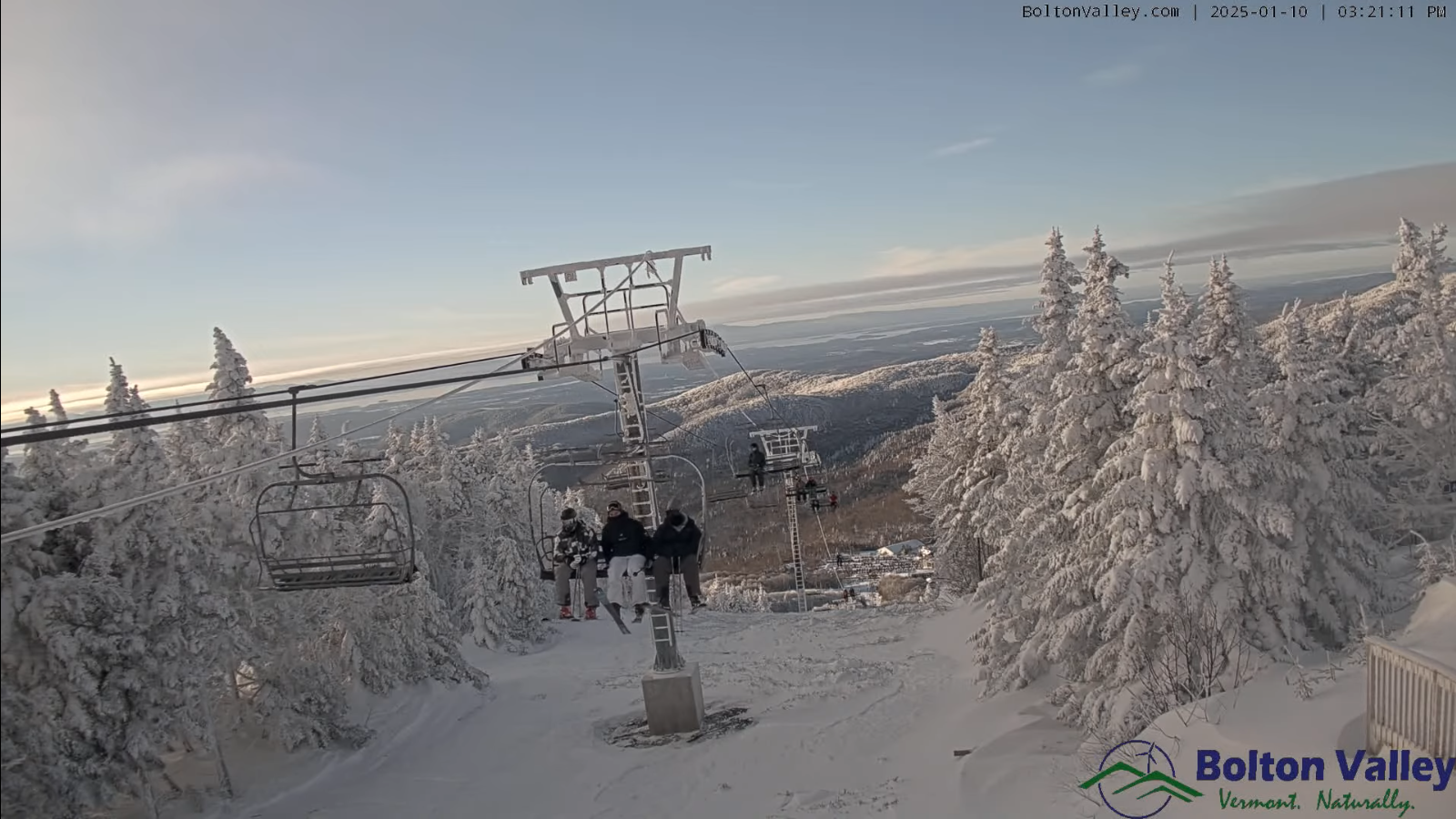
RH/1-10-25forecast][end]

TONIGHT: Considerable clouds. Scattered flurries with a dusting. Temperatures in the mid-teens. Northwest winds 10 mph.
TOMORROW: A few northern mountain flurries, otherwise clouds mixing with intervals of sun eastern and southern areas. A high in the low 20s. Northwest winds 10 mph.
FRIDAY NIGHT: Thickening clouds…leading to a rising chance for flurries late. A light coating late. A low mid-teens. Little wind.
SATURDAY: Gray. Chance for light spotty accumulating snow or flurries. Dusting to an inch. A high lower 20s. Light southeast winds.
Looking further ahead

SATURDAY NIGHT: A lingering flurry northern areas, then becoming partly to mostly late. A low near 15.
SUNDAY: Clouds, with periods of afternoon sun. A high near 25. (to feel like a mild day)

Full Wolf Moon Monday at 5:27 PM
MONDAY: Mostly cloudy. Scattered northern flurries early. A low 5 to 15. Near seasonable highs pushing 30 degrees.
TUESDAY: Mainly gray. Chance for flurries northern areas. A low 15 to 20. A high around 25.
Average low ranging thru the single digits. Average high mid-20s to near 30.
Peak Meteorological Winter 1-23-25
RH/1-8-25forecast][end]
TONIGHT: Overcast. Scattered lingering snow showers or flurries especially northern areas. Dusting to a couple fluffy inches northern mountains. Little change in temperature.A low around 5 above. Northwest winds 10 to 15 mph.
TOMORROW: Mainly gray. Scattered lingering snow showers or flurries mainly northern areas. Dusting to an inch. Not as cold. A high 15 to 20. Northwest winds 10 to 20 mph.
THURSDAY NIGHT: Considerable clouds. Scattered flurries with minor accumulations. A low mid-teens. Northwest winds 10 to 15 mph.
FRIDAY: A stray northern flurry, Otherwise clouds with intervals of sun eastern and southern areas. A high around 20. Northwest winds 10 mph.
Looking further ahead
FRIDAY NIGHT: Thickening clouds…leading to a rising chance for light snow showers/flurries late overnight. A low 10 to 15.
SATURDAY: Gray. Chance for light spotty accumulating snow or flurries. A high lower 20s.
SUNDAY: Maybe an early flurry, otherwise clouds mixing with sunny intervals. A low 10 to 15. A high around 25. (to feel like a mild day)
Full Wolf Moon Monday at 5:27 PM
MONDAY: Scattered northern flurries early. Otherwise clouds mixing with a few breaks of sun. A low around 10. A high in the mid-20s.
Average low ranging thru the single digits. Average high mid-20s to near 30.
Peak Meteorological Winter 1-23-25
RH/1-8-25forecast][end]


Winter Weather Advisory continues thru late Wednesday eastern Chittenden, Lamoille, and Franklin Counties.
TONIGHT: Cloudy. Occasional light accumulating snow showers or flurries. Dusting to an inch northern Greens. A low 5 to 10. Northwest winds 10 to 15 mph lowering wind chills.
TOMORROW: Gray. Scattered lingering snow showers or flurries, mainly northern mountains. Dusting to an inch northern Greens. Well below normal in temperature. A high just upper single digits. Northwest winds 10 to 20 mph lowering wind chills.
WEDNESDAY NIGHT: Overcast. Scattered lingering snow showers or flurries especially northern areas. Minor accumulation. Little change in temperature.A low around 5 above. Northwest winds 10 to 15 mph.
THURSDAY: Lots of clouds. Scattered lingering snow showers or flurries especially northern areas. Dusting to an inch northern Greens. Not as cold. A high in the mid to upper teens. Northwest winds 10 to 20 mph.
Looking further ahead
THURSDAY NIGHT: Mostly cloudy. A few flurries near the mountains. A low 10 to 15.
FRIDAY: Maybe a stray morning flurry, then breaks of sunshine. A high about 20.
SATURDAY: Predominantly gray. Chance for light spotty accumulating snow or flurries developing. Minor accumulation. A low around 10. A high 20 to 25.
SUNDAY: Maybe an early flurry, otherwise lingering clouds. A low 10 to 15. A high near 25. (to feel like a mild day)
Average low ranging thru the single digits. Average high mid-20s to near 30.
Full Wolf Moon Monday 1-13-25 at 5:27 PM
Peak Meteorological Winter 1-23-25
RH/1-7-25forecast][end]

Winter Weather Advisory overnight thru late Wednesday northern Green Mountains
TONIGHT: Scattered clouds this evening then clouding up. Rising chance for light snow showers or flurries developing far northern areas with light coatings.Frigid.An evening low around zero to 5 above. Northwest winds 10 mph lowering wind chills.
TOMORROW: Considerable cloudiness. Occasional light accumulating snow showers or flurries especially northern areas. Dusting to an inch or two northern Greens. A high around 15. Northwest winds 10 to 20 mph lowering wind chills.
TUESDAY NIGHT: Cloudy. Occasional light accumulating snow showers or flurries. Dusting to an inch or two northern Greens. Frigid. A low around 5 above. Northwest winds 10 to 15 mph lowering wind chills.
WEDNESDAY: Predominantly gray. Scattered lingering snow showers or flurries, mainly northern mountains. Dusting to an inch northern Greens. Well below normal in temperature. A high just 5 to 10 above. Northwest winds 10 to 20 mph lowering wind chills.
Looking further ahead
WEDNESDAY NIGHT: Overcast. Scattered lingering snow showers or flurries especially northern areas. Minor accumulation. A low around 5 above.
THURSDAY: Mostly cloudy. Scattered lingering snow showers or flurries, especially northern areas. Minor accumulation. Not as cold. Slight warming trend. A high 15 to 20.
FRIDAY: Maybe a stray morning flurry with a dusting, then intervals of sunshine. A low 10 to 15. A high near 20.
Average low ranging thru the single digits. Average high mid-20s to near 30.
Full Wolf Moon Monday 1-13-25 at 5:27 PM
Peak Meteorological Winter 1-23-25
RH/1-6-25forecast][end]