Updated Monday Evening Forecast — March 29th, 2021

TONIGHT: Clear and moonlit skies. A low mid-20s. Light west winds.

TOMORROW: Mostly sunny with a few more high clouds afternoon northern areas. Much warmer turning breezy. A high in the upper 50s to around 60. South breeze 10 to 20 mph and little stronger toward Lake Champlain.

TUESDAY NIGHT: High cloudiness and Moonlit. A low 35 to 40. South winds 10 mph but brisk near Lake Champlain.

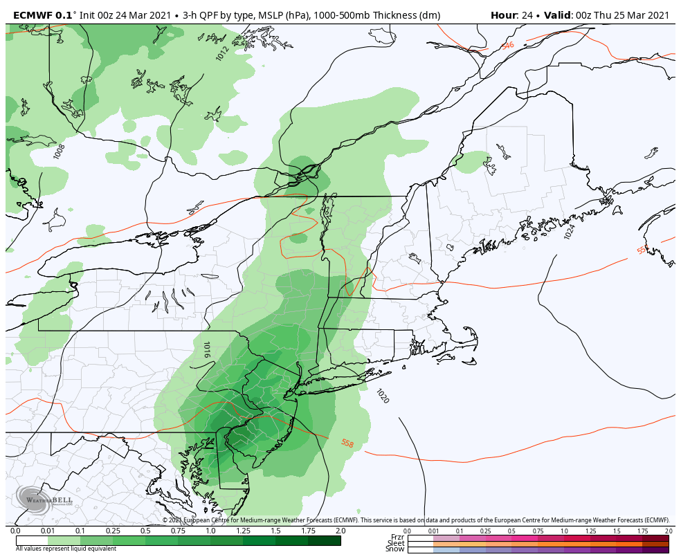
WEDNESDAY: Gray. Thickening clouds. A rising chance for rain showers toward the Champlain Valley late. A high in the low 60s. South winds 10 to 15 mph more breezy toward Lake Champlain.

Looking further ahead…

WEDNESDAY NIGHT: Overcast.Chance for rain or rain showers mixed with wet snow late. A low around near 32.

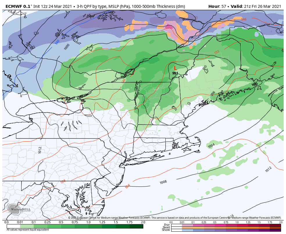
THURSDAY: Cloudy. Chance for a “wintry mix” transitioning to all snow with several inches of accumulation toward the Champlain Valley Temperatures falling through the 30s.

FRIDAY: Lots of clouds. Maybe a stray mountain flurry. A low around 20. A high around 30.

SATURDAY: Mostly sunny then partly cloudy in the afternoon. A low around 20. A high in the upper 40s.

Average low ranging thru the 20s Average highs mid-40s to low 50s

Start of Meteorological Summer June 6th… Summer peaks approx.. July 22nd based off local climatology.

RH/3-29 category forecast][end]

Updated Monday Morning Forecast — March 29th, 2021

Wind Advisory in effect thru 5 PM

TODAY: Clouds with occasional snow showers and a risk of a snow squall a dusting to 2” with the most in elevated northern terrain. Watch for slick spots elevated terrain. Increasing sunshine developing late this morning into the afternoon. Blustery to windy and colder. Temperatures dip this morning below freezing eventually rising into the mid-30s to near 40 this afternoon. West to northwest winds 15 to 35 mph with higher gusts over 50 mph especially southern Greens.

TONIGHT: A few high clouds, otherwise mostly clear and moonlit. A low mid to upper 20s. Light west winds.

TUESDAY: Mostly sunny with a few more high clouds late. A high in the upper 50s to around 60. South breeze 10 to 15 mph.

Looking further ahead…

TUESDAY NIGHT: Partly cloudy with mainly high clouds. A low 35 to 40.

WEDNESDAY: Gray skies with thickening clouds. A rising chance for rain showers in the afternoon. A high around 60.

THURSDAY: Chance for rain…with a transition to accumulating wet snow in the afternoon. A couple of inches possible. A low around near 32. A high mid to upper 30s.

FRIDAY: Mostly cloudy. Maybe a few stray mountain flurries. A low in the low to mid 20s. A high only near 32.

Average low ranging thru the 20s Average highs mid-40s to low 50s

Start of Meteorological Summer June 6th… Summer peaks approx.. July 22nd based off local climatology.

RH/3-29 category forecast][end]

Updated Friday Evening Forecast — March 26th, 2021

Flood Watch in effect thru Saturday Evening…

TONIGHT: Cloudy. Showers mixing with wet snowflakes higher northern terrain before exiting overnight. A low 32 to 35. West winds shifting to northwest 10 to 25 mph with higher gusts in the mountains this evening…decreasing overnight.

TOMORROW: Morning clouds give way to partly sunny skies. A bit colder. A high 45 to 50. Light northwest winds.

SATURDAY NIGHT: Partly cloudy in the evening, then clouding up. A few rain showers late. A low 32 to 35. Light southeast winds picking up 10 to 15 mph overnight.

SUNDAY: Overcast. Periods of light rain…becoming moderate at times in the afternoon. Breezy to windy at times. A high ranging in the 40s. Southeast winds 10 to 20 mph with higher gusts northern Greens.

Looking further ahead…

SUNDAY NIGHT: Rain tapering off as scattered showers before changing to snow showers with a dusting to an inch accumulation. A low around 25.

MONDAY: Clouds and a few leftover snow showers give way to breaks of afternoon sunshine, blustery to windy and colder. A high 35 to 40.

TUESDAY: Clouds mixing with lots of sunshine. An evening low in the mid-20s. A high around 55.

WEDNESDAY: Fair early, then clouding up with rain changing to wet snow. A low 32 to 35. A high reaching into the mid-60s.

Average low mid-teens to upper-20s Average highs low to mid 40s.

Start of Meteorological Summer June 6th… Summer peaks approx.. July 22nd based off local climatology.

RH/3-26-21 category forecast][end]

Updated Friday Morning forecast — March 26th, 2021

Flood Watch in effect into Saturday Evening…

TODAY: Lots of clouds. Rain showers…moderate to heavy at times with a few embedded thunderstorms…one or two strong. Breezy to windy late today. Still mild. A high 60 to 65. South to southeast winds shifting to southwesterly late at 10 to 20 mph and gusty.

TONIGHT: Cloudy. Showers mixing with wet snow higher northern terrain with a light coating in some elevated areas. A low

32 to 35. West wind shifting to northwest 10 to 25 mph with higher gusts in the mountains.

SATURDAY: Any leftover wet snow flakes far northern areas exit, then intervals of sunshine. A little colder. A high in the mid to upper 40s. Northwest winds 10 mph becoming light.

Looking further ahead…

SATURDAY NIGHT: Overcast. Rain showers likely toward daybreak possibly mixed with wet snow flakes. A low 32 to 35.

SUNDAY: Gray. Periods of rain…moderate to possibly heavy at times in the afternoon. A high 45 to 50.

MONDAY: Clouds and a few leftover snow showers give way to breaks of afternoon sunshine, blustery to windy and colder. A low 20 to 25. A high in the mid-30s

TUESDAY: Clouds mixing with lots of sunshine. An evening low in the mid-20s. A high 50 to 55.

Average low mid-teens to upper-20s Average highs low to mid 40s.

Start of Meteorological Summer June 6th… Summer peaks approx.. July 22nd based off local climatology.

RH/3-26-21 category forecast][end]

Updated Thursday Evening Forecast — March 25th, 2021

TONIGHT: Fair & very mild this evening with a few high clouds, thickening overnight. Rain showers developing before daybreak. A low 45 to 50. Light southeast winds.

Flood Watch Friday morning into Saturday Evening…

TOMORROW: Lots of clouds. Rain showers…moderate to heavy at times in the morning with a few embedded thunderstorms. A round of moderate to heavy rain showers with embedded thunderstorms late afternoon…some strong. Breezy to windy at times and still mild with a high upper 50s to about 60. South to southeast winds shifting to southwesterly late at 10 to 20 mph and gusty.

FRIDAY NIGHT: Cloudy. Scattered rain showers mixing with wet snow north of the Barre-Montpelier. A minor coating in the higher terrain. A low around 35. West wind shifting to northwest 10 to 25 mph with higher gusts in the mountains.

SATURDAY: A few wet snow showers higher terrain northern areas…exiting in the morning. Otherwise clouds with a few breaks of afternoon sunshine. Colder. A high around 45. Northwest winds 10 mph becoming light.

Looking further ahead…

SATURDAY NIGHT: Rising chance for a few rain showers toward daybreak. A low 32 to 35.

SUNDAY: Gray. Good chance for periods of rain moderate to possibly heavy at times. A high 45 to 50.

MONDAY: Clouds and a few leftover snow showers give way to breaks of afternoon sunshine, blustery to windy and colder. A low in the low to mid 20s. A high around 35.

TUESDAY: Clouds mixing with lots of sunshine. A low 20 to 25. A high near 50.

Average low mid-teens to upper-20s Average highs low to mid 40s.

Start of Meteorological Summer June 6th… Summer peaks approx.. July 22nd based off local climatology.

RH/3-25-21 category forecast][end]

Updated Thursday Morning Forecast — March 25th, 2021

TODAY: Morning clouds then periods of sunshine with more clouds again arriving this afternoon. Warmer, with a record high pushing toward 70. Winds becoming southwest 10 to 15 mph.

TONIGHT: Thickening clouds. Rain showers developing before daybreak. A low 45 to 50. Light south winds.

Flood Watch Friday morning into Saturday Evening…

FRIDAY: Gray. Rain showers…moderate to heavy at times in the morning with a few embedded thunderstorms. A round of moderate to heavy rain showers with embedded thunderstorms late afternoon…some strong. Breezy to windy at times and still mild with a high around 60. South to southeast winds shifting to southwesterly at 10 to 20 mph and gusty.

Looking further ahead…

FRIDAY NIGHT: Cloudy. Scattered rain showers changing to wet snow north of the Barre-Montpelier. A dusting to an inch of slush. A low 32 to 35 degrees.

SATURDAY: A few wet snow showers higher terrain northern areas…exiting in the morning. Otherwise clouds with a few breaks of afternoon sunshine. Colder. A high 40 to 45.

SUNDAY: Gray. Chance for rain…mixing with wet snow higher terrain Northeast Kingdom. A low 30 to 35. A high around 40.

MONDAY: Clouds and a few leftover snow showers give way to breaks of afternoon sunshine, blustery to windy and colder. A low 25 to 30. A high around 35.

TUESDAY: Scattered snow showers give way to partial afternoon sunshine and blustery. A low 20 to 25. A high 45 to 50.

Average low mid-teens to upper-20s Average highs low to mid 40s.

Start of Meteorological Summer June 6th… Summer peaks approx.. July 22nd based off local climatology.

RH/3-25-21 category forecast][end]

Updated Wednesday Evening Forecast — March 24th, 2021

TONIGHT:Mostly cloudy. Scattered light rain showers or sprinkles. A low in the mid-40s. Southeast winds 10 mph.

TOMORROW: Partly to mostly sunny. Warmer with a record high 65 to 70. Winds becoming southwest 10 to 15 mph.

THURSDAY NIGHT: Thickening clouds. Rain showers developing toward daybreak. A low 45 to 50. Light south winds.

FRIDAY: Gray. Rain showers…moderate to heavy at times in the morning with a few rumbles of thunder. A round of moderate to briefly heavy rain showers with isolated thunderstorms in the afternoon. Breezy to windy at times with a high 60 to 65. South to southeast winds shifting to southwesterly at 10 to 20 mph and gusty.

Looking further ahead…

FRIDAY NIGHT: Cloudy. Scattered rain showers changing to wet snow north of the Barre-Montpelier. A dusting to an inch of slush. A low near 32 degrees.

SATURDAY: A few wet snow showers higher terrain northern areas…exiting in the morning. Otherwise clouds with a few breaks of afternoon sunshine. Colder. A high in the low 40s.

SUNDAY: Gray. Chance for rain and wet snow. A few inches accumulation especially toward the Northeast Kingdom. A low near 32. A high 35 to 40.

MONDAY: Clouds and a few leftover snow showers give way to breaks of afternoon sunshine, blustery and colder. A low around 30. A high in the mid to upper 30s.

TUESDAY: A low around 20. A high 40 to 45.

Average low mid-teens to upper-20s Average highs low to mid 40s.

Start of Meteorological Summer June 6th… Summer peaks approx.. July 22nd based off local climatology.

RH/3-24-21 category forecast][end]

Updated Wednesday Morning Forecast — March 24th, 2021

TODAY: Clouds mixing with breaks of sunshine. A few late day rain showers developing. A high in the upper 50s or near 60. South winds 10 mph.

TONIGHT:Mostly cloudy. Scattered light rain showers or sprinkles. A low in the mid-40s. South to southeast winds 10 mph.

THURSDAY: Mixed clouds and sun, with more clouds in the afternoon. Warmer with a record high temperature 65 to near 70. Winds becoming southwest 10 to 15 mph.

Looking further ahead…

THURSDAY NIGHT: Thickening clouds. Chance for rain showers after midnight. A low 45 to 50.

FRIDAY: Mainly gray. Occasional rain showers likely…maybe a few rumbles of thunder with possible gusty winds late. A high in the low 60s.

FRIDAY NIGHT: Cloudy. Rain showers, tailing off with wet snow especially northern higher terrain. A light slushy coating of snow higher northern terrain. A low around 35.

SATURDAY: Considerable cloudiness maybe some breaks of sun. Leftover wet snow or rain showers northern elevated terrain. Colder. A high mid-30s far northern areas to low 40s elsewhere.

SUNDAY: Gray. Chance for wet “sugar snow” A few inches accumulation especially elevated terrain. A low 30 to 35. A high mid to upper 30s.

MONDAY: Clouds give way to breaks of afternoon sunshine, blustery and colder. A low around 30. A high in the mid to upper 30s.

Average low mid-teens to upper-20s Average highs low to mid 40s.

Start of Meteorological Summer June 6th… Summer peaks approx.. July 22nd based off local climatology.

RH/3-24-21 category forecast][end]

Updated Tuesday Evening Forecast — March 23rd, 2021

TONIGHT: Fair with periods of high cloudiness. A low 32 to 35.Light south winds.

TOMORROW: Clouds mixing with breaks of sunshine. Maybe a late day rain shower. A high in the upper 50s or near 60. South winds 10 mph.

WEDNESDAY NIGHT:Mostly cloudy. Scattered light rain showers. A low in the mid-40s. South to southeast winds 10 mph.

THURSDAY: Mixed clouds and sun, with more clouds in the afternoon. Warmer. A high 65 to near 70. Winds becoming southwest 10 to 15 mph.

Looking further ahead…

THURSDAY NIGHT: Thickening clouds. Chance for rain showers after midnight. A low 45 to 50.

FRIDAY: Mainly gray. Good chance for occasional rain showers…mixing with wet snow Friday night. A high 55 to 60.

SATURDAY: Considerable cloudiness. Chance for rain showers mixing with wet snow. Possible wet snow accumulation elevated terrain. Colder. Temperatures 35 to 40.

SUNDAY: Gray. Chance for wet “sugar snow” A few inches accumulation especially elevated terrain. A low 30 to 32. A high 35 to 40.

Average low mid-teens to upper-20s Average highs low to mid 40s.

Start of Meteorological Summer June 6th… Summer peaks approx.. July 22nd based off local climatology.

RH/3-23-21 category forecast][end]

Updated Tuesday morning forecast — March 23rd, 2021

TODAY: Sun filtered by high cloudiness. A high in the mid-60s. Light south breeze.

TONIGHT: Fair with high cloudiness. A low 32 to 35.Light south winds.

WEDNESDAY: Mainly cloudy. A rising chance for late day rain showers. A high 55 to 60. Light south breeze.

Looking further ahead…

WEDNESDAY NIGHT:Mainly cloudy. Scattered light rain showers. A low mid to upper 40s.

THURSDAY: Mixed clouds and sun. Warmer. A high mid-60s to around 70.

FRIDAY: Cloudy and turning unsettled. Good chance for rain showers. A low 45 to 50. A high 55 to 60.

SATURDAY: Considerable cloudiness. Chance for rain showers mixing with snow. Possible wet snow accumulation elevated terrain. Colder. Temperatures 35 to 40.

SUNDAY: Gray. Chance for wet “sugar snow” mixed with rain valley floors A few inches accumulation across the elevated terrain. A low 30 to 32. A high 35 to 40.

Average low mid-teens to upper-20s Average highs low to mid 40s.

Start of Meteorological Summer June 6th… Summer peaks approx.. July 22nd based off local climatology.

RH/3-23-21 category forecast][end]