Updated Thursday Evening Forecast — March 23rd, 2023

TONIGHT: A few lingering evening rain showers dry up northern areas. Otherwise clouds breaking up overnight. A low upper 20s to around 30. West to northwest winds 10 mph.

TOMORROW: Clouds, with a few northern flurries in the morning, then lots of sunshine filtered by high clouds. A bit blustery. A high near 40. Northwest winds 10 to 15 mph.

FRIDAY NIGHT: Fair with high cloudiness. A low around 20. Light northeast winds.

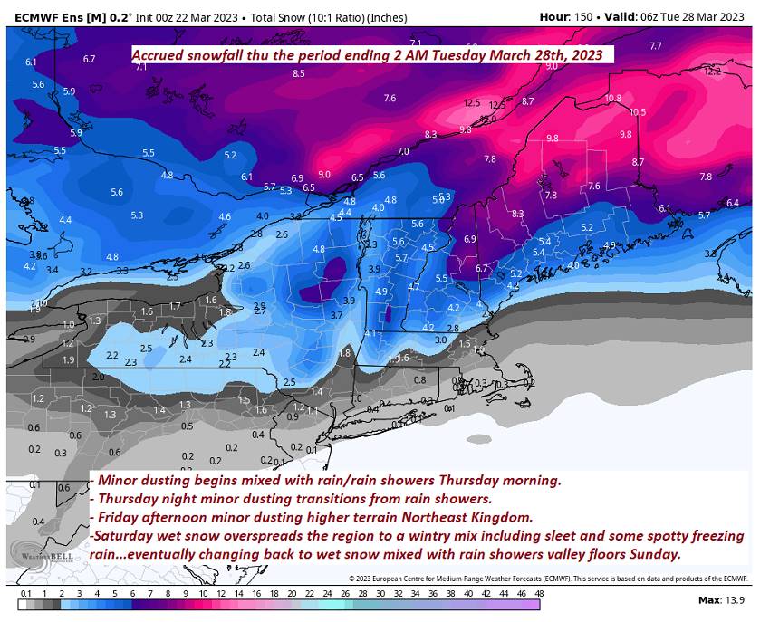
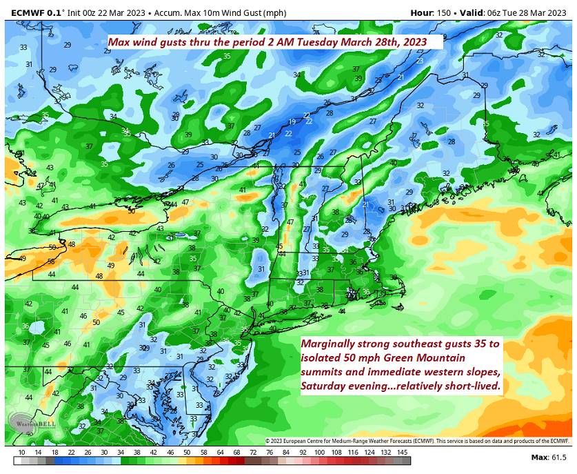
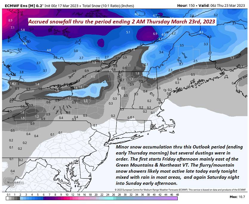
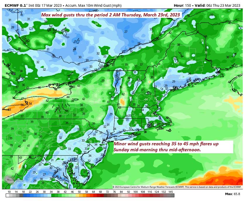
SATURDAY: Thickening clouds. A period of wet accumulating snow likely late with an inch or two accumulation. Breezy at times in the afternoon and evening. A high mid-30s. Southeast winds 10 to 20 mph.

Looking further ahead

SATURDAY NIGHT: Cloudy. Wet snow showers mixed with sleet off and on, but accumulations of an inch or so with slick travel. A low 32 to 35.

SUNDAY: Mainly cloudy. Chance for leftover mixed wet snow and sleet and rain showers valleys with additional minor accumulation elevated terrain. A high near 40. Blustery from the northwest.

MONDAY: Maybe a northern mountain flurry early. Otherwise becoming partly to mostly sunny. A low upper 20s. A high upper 30s near 40.

TUESDAY: Partly to mostly sunny. A low 25 to 30. A high around 40.

Average lows upper-teens to middle 20s. Average highs 40 to 45.

Start of Meteorological summer arrives June 6th.

RH/3-23 forecast][end]

Updated Thursday morning Forecast — March 23rd, 2023

TODAY: Gray skies.Light rain or rain showers developing…possibly moderate for time this afternoon. A couple wet snow flakes higher elevations. Areas of fog possible. A high mid to upper 40s. Light south winds.

TONIGHT: Variable clouds. A few evening rain showers northern areas. A low around 30. West to northwest winds pick up to 10 to 20 mph.

FRIDAY: Mostly cloudy in the morning, then sunshine filtered by high clouds & blustery. A high upper 30s. Northwest winds 10 to 20 mph.

Looking further ahead

FRIDAY NIGHT: Fair with high cloudiness. A low 20 to 25.

SATURDAY: Thickening clouds. Good chance for wet accumulating snow developing in the afternoon with 1 to locally 4” slushy accumulation…mixing with sleet and pockets of freezing rain going into Saturday night. Slushy slippery travel. Breezy at times in the afternoon and evening. A high mid-30s. Breezy from the southeast.

SUNDAY: Mainly cloudy. Chance for leftover mixed precipitation changing to valley rain showers and mountain snow showers. A low 32 to 35. A high in the upper 30s. Blustery from the northwest.

MONDAY: Chance for leftover flurries early. Otherwise becoming partly sunny. A low upper 20s to around 30. A high about 40.

TUESDAY: Mostly cloudy. Chance for light snow or snow showers. A low 25 to 30. A high around 40.

Average lows upper-teens to middle 20s. Average highs 40 to 45.

Start of Meteorological summer arrives June 6th.

RH/3-23 forecast][end]

Updated Wednesday Evening Forecast — March 22nd, 2023

TONIGHT: Cloudy. A few rain showers developing northern areas about late evening on. A low mid to upper 30s. Light southeast winds.

TOMORROW: Gray.Light rain or rain showers developing…possibly moderate for time in the afternoon. Maybe a few wet snow flakes higher terrain. Areas of fog possible. A high mid to upper 40s. Light south winds.

THURSDAY NIGHT: Variable clouds. A few evening rain showers northern areas. A low in the upper 20s. West to northwest winds pick up to 10 to 20 mph.

FRIDAY: Early clouds, then increasing amounts of sunshine & blustery. A high 35 to 40. Northwest winds 10 to 20 mph.

Looking further ahead

FRIDAY NIGHT: Fair with high cloudiness. A low 20 to 25.

SATURDAY: Thickening clouds. Chance for a periods of wet accumulating snow leading to a wintry mix Saturday evening. Slushy slippery travel with a couple to a few inches possible. Breezy to windy late. A high near 35.

SUNDAY: Mainly cloudy. Chance for leftover wet snow showers mixed with rain valleys. A low 30 to 35. A high in the upper 30s.

MONDAY: Mostly cloudy with a chance for leftover flurries early. A low upper 20s to around 30. A high in the low 40s.

TUESDAY: Mostly cloudy. Chance for light snow or snow showers. A low Around 32. A high 40 to 45.

Average lows upper-teens to middle 20s. Average highs 40 to 45.

Start of Meteorological summer arrives June 6th.

RH/3-22 forecast][end]

Updated Wednesday Morning Forecast — March 22nd, 2023

TODAY: Periods of sunshine before more clouds arrive later on this afternoon. A high in the lower 50s (Sap run?). Light southeast breeze.

TONIGHT: Cloudy. Chance for a rain shower or two northern tier mainly this evening. A low around 35. Light south to southeast winds.

THURSDAY: Gray.Light rain or rain showers developing…possibly moderate for time in the afternoon. Maybe a few wet snow flakes higher terrain. Areas of fog. A high in the upper 40s. Light south winds.

Looking further ahead

THURSDAY NIGHT: Scattered rain showers exiting before midnight. Otherwise variable clouds. A low in the lower 30s.

FRIDAY: Early clouds, then filtered sunshine thru high clouds. A high in the upper 30s.

SATURDAY: Thickening clouds. Chance for a periods of wet snow leading to a wintry mix Saturday evening. Slushy slippery travel with a couple to a few inches possible. Breezy to windy late. A low around 25. A high near 35.

SUNDAY: Mainly cloudy. Chance for leftover wet snow showers mixed with rain valleys. A low 30 to 35. A high in the upper 30s.

MONDAY: Mostly cloudy with a chance for leftover flurries early. A low upper 20s to around 30. A high in the low 40s.

TUESDAY: Mostly cloudy. Chance for light snow or snow showers. A low Around 32. A high 40 to 45.

Average lows upper-teens to middle 20s. Average highs 40 to 45.

Start of Meteorological summer arrives June 6th.

RH/3-22 forecast][end]

Updated Tuesday Evening Forecast — March 21st, 2023

TONIGHT: High cloudiness otherwise fair. A low 20 to 25. Little wind.

TOMORROW: Intervals of sun then more clouds in the afternoon. A high in the upper 40s (Sap run?). Light southeast breeze.

WEDNESDAY NIGHT: Cloudy. Chance for a rain shower or two northern tier in the evening. A low around 35. Light south to southeast winds.

THURSDAY: Gray.Light rain developing in the morning with areas of fog. Rain moderate at times later in the afternoon. A high around 45. Light south winds.

Looking further ahead

THURSDAY NIGHT: Scattered rain showers tail off as few mountain flurries northern areas. Otherwise becoming partly cloudy. A low upper 20s.

FRIDAY: Early clouds with any flurries exiting just minor accumulation, then filtered sunshine thru high clouds.. A high 35 to 40.

SATURDAY: Thickening clouds. Chance for a periods of wet snow leading to a wintry mix in the afternoon Slushy slippery travel. Breezy to windy late. A low 15 to 20. A high 32 to 35.

SUNDAY: Mainly cloudy. Chance for leftover snow showers and flurries with light coatings. A low in the lower 30s. A high 35 to 40.

Average lows upper-teens to middle 20s. Average highs 40 to 45.

Start of Meteorological summer arrives June 6th.

RH/3-21 forecast][end]

Updated Tuesday Morning Forecast — March 21st, 2023

TODAY: Mixed clouds and sun, except mostly cloudy northern areas where there could be a stray flurry. A high mid-40s. (Sap run?) Westerly breeze 10 to 15 mph shifting to northwesterly.

TONIGHT: High cloudiness. A low 20 to 25. Little wind.

WEDNESDAY: Intervals of sun then thickening clouds. A high in the upper 40s (Sap run?). Light southeast breeze.

Looking further ahead

WEDNESDAY NIGHT: Cloudy. Chance for a rain shower or two northern tier in the evening. A low around 35.

THURSDAY: Gray.Chance for spotty rain late morning on moderate at times in the afternoon. A high around 45.

FRIDAY: Early clouds with any flurries exiting just minor accumulation, then filtered sunshine thru high clouds. A low upper 20s. A high 35 to 40.

SATURDAY: Thickening clouds. Chance for a wintry mix developing in the afternoon with slushy travel. Becoming breezy to windy late. A low 15 to 20. A high 32 to 35.

SUNDAY: Mainly cloudy. Chance for leftover snow showers and flurries with light coatings. A low in the lower 30s. A high 35 to 40.

Average lows upper-teens to middle 20s. Average highs 40 to 45.

Start of Meteorological summer arrives June 6th.

RH/3-20 forecast][end]

Updated Monday Evening Forecast — March 20th, 2023

Vernal Equinox 5:24 PM

TONIGHT: Becoming partly to mostly cloudy. A low in the 20s. Light west to southwest winds.

TOMORROW: Mixed clouds and sun, with more clouds northern mountains with possible flurry late. A high 40 to 45. Westerly breeze 10 to 15 mph shifting to northwesterly. (Sap run?)

TUESDAY NIGHT: High cloudiness, thickening up overnight. A low upper teens to mid-20s. Little wind.

WEDNESDAY: Intervals of sun giving way to more clouds. A high mid to upper 40s. Light southeast breeze. (Sap run?)

Looking further ahead

WEDNESDAY NIGHT: Cloudy. Scattered rain showers with wet snowflakes in the hills mainly in the evening. A low mid-30s.

THURSDAY: Gray.Chance for scattered rain or snow showers early, giving way to periods of rain, possibly moderate at times. A high 40 to 45.

FRIDAY: Early clouds with any flurries exiting, then filtered sunshine thru high clouds. A low 32 to 35. A high 35 to 40.

SATURDAY: Thickening clouds. Chance for snow, possibly a few inches. A low mid-teens to near 20. A high near 35.

Average lows upper-teens to middle 20s. Average highs 40 to 45.

Start of Meteorological summer arrives June 6th.

RH/3-20 forecast][end]

Updated Monday Morning Forecast — March 20th, 2023

TODAY: Sunshine predominates, but mixes with a few clouds and a stray flurry or two northern border areas. A high in the low 40s. Southwest breeze 10 to 15 mph this afternoon. (Sap run?)

Vernal Equinox 5:24 PM

TONIGHT: Becoming partly to mostly cloudy. A low in the 20s. Light southwest winds.

TUESDAY: Mixed clouds and sun, with more clouds northern mountains. A high around 45. Westerly breeze 10 to 15 mph. (Sap run?)

Looking further ahead

TUESDAY NIGHT: High cloudiness, thickening up overnight. A low in the 20s.

WEDNESDAY: Intervals of sun giving way to more clouds. A low upper 20s to low 30s. A high mid to upper 40s. (Sap run?)

THURSDAY: Gray.Chance for scattered rain or snow showers early, giving way to periods of rain, possibly moderate at times. A low around 35. A high in the mid-40s.

FRIDAY: Early clouds with any flurries exiting, then filtered sunshine thru high clouds. A low around 32. A high around 40.

Average lows upper-teens to middle 20s. Average highs 40 to 45.

Start of Meteorological summer arrives June 6th.

RH/3-20 forecast][end]

Updated Friday Evening Forecast — March 17th, 2023

TONIGHT: Scattered light rain showers or sprinkles dries up then partial clearing overnight. Watch for icy spots east of the Green Mountains. A low upper 20s to low 30s. Southwest winds shifting to westerly overnight 10 mph.

TOMORROW: A few clouds early, then partly to mostly sunny. A high around 40. Light west to northwest winds. (Possible sap run)

SATURDAY NIGHT: Mostly cloudy. Good chance for flurries developing with minor accumulation in the mountains. A low around 20. West winds 10 mph.

SUNDAY: Mostly cloudy, blustery and colder. Scattered mountain snow showers and valley flurries with a light coating in spots mainly northern areas. A high in the upper 20s to about 30. West winds 10 to 25 mph and gusty.

Looking further ahead

SUNDAY NIGHT: Mostly clear with a few high clouds. A low 15 to 20.

MONDAY: Sunshine mixing with a few clouds. A high mid to upper 30s.

TUESDAY: Partly sunny. A low in the mid to upper teens. A high around 45. (Sap run?)

WEDNESDAY: Sunshine filtered by high clouds. A low upper 20s to low 30s. A high mid-40s to near 50. (Sap run?)

Average lows mid-teens to lower 20s. Average highs mid-30s to low 40s.

Vernal Equinox March 20th Start of Meteorological summer arrives June 6th.

RH/3-17 forecast][end]

Updated Friday Morning Forecast — March 17th, 2023

TODAY: Cloudy. Light rain develops by early afternoon mixed with a few wet snowflakes Northeast Kingdom. A high around 40. Southeast winds 10 mph.

TONIGHT: Occasional light rain showers, mixing with wet snow flakes early…exiting later overnight to brief partial clearing. Watch for icy spots east of the Green Mountains. A low upper 20s to low 30s. Southwest winds shifting to westerly overnight 10 mph.

SATURDAY: Partly cloudy early, then lots of sunshine. A high around 40. Light west to northwest winds. (Possible sap run)

Looking further ahead

SATURDAY NIGHT: Variably cloudy. Good chance for flurries developing with minor accumulation in the mountains. A low 15 to 20.

SUNDAY: Mostly cloudy, blustery and colder. Scattered mountain snow showers and valley flurries with a light coating in spots mainly northern areas. A high in the upper 20s to about 30.

MONDAY: Sunshine mixing with more clouds. A low 15 to 20. A high mid to upper 30s.

TUESDAY: Partly sunny. A low in the mid to upper teens. A high around 45. (Sap run?)

WEDNESDAY: Sunshine filtered by high clouds. A low upper 20s to low 30s. A high mid-40s to near 50. (Sap run?)

Average lows mid-teens to lower 20s. Average highs mid-30s to low 40s.

Vernal Equinox March 20th Start of Meteorological summer arrives June 6th.

RH/3-17 forecast][end]