Updated Wednesday Morning Forecast — April 12th, 2023

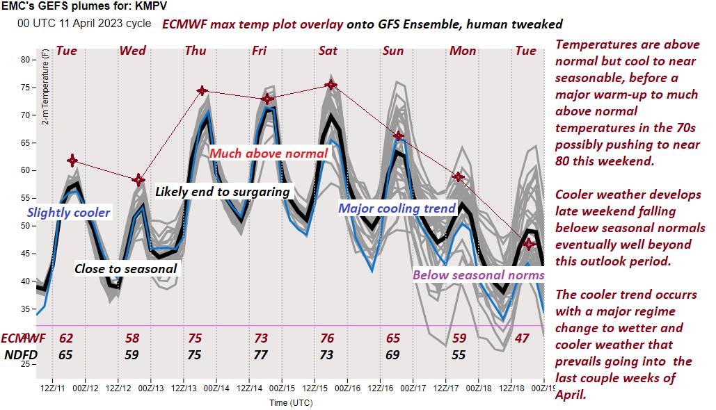
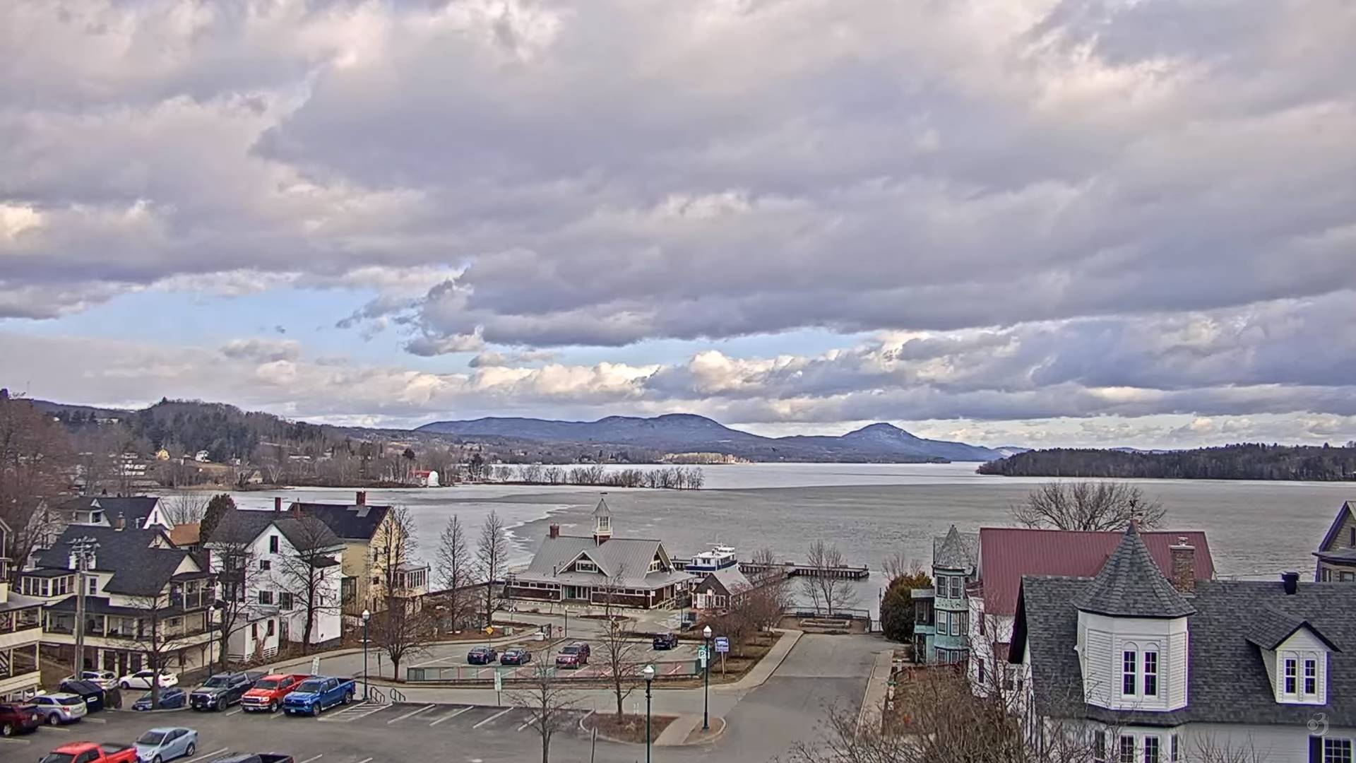
TODAY: More clouds than sun. A high upper 50s. Northwest winds 10 to 25 mph.

TONIGHT: Occasional cloudy periods with threat for a sprinkle. A low ranging thru the 40s. Light southeast winds.

THURSDAY: Pick of the week. Mostly sunny well above normal in temperature. A near record high 75 to 80. West breeze 10 mph.

Looking further ahead

THURSDAY NIGHT: Mostly clear in the evening, then some high cloudiness, partially moonlit & mild.A low around 55.

FRIDAY: Lots of sunshine with a few high clouds. A high 70 to 75.

SATURDAY: Filtered sunshine thru high cloudiness. Remaining very mild. A low around 50. A near record high

75 to 80.

SUNDAY: Considerable cloudiness. Chance for late day or evening shower. A low around 50. A high 65 to 70.

MONDAY: Cloudy with some intervals of afternoon sunshine. Chance for morning rain showers…briefly moderate at times. Damp and cooler. A low around 45. A high around 55.

Average lows 30 to 35. Average highs low to mid 50s.

Start of Meteorological summer arrives June 6th.

RH/4-12 forecast][end]

Updated Tuesday Evening Forecast — April 11th, 2023

Red Flag Warning Champlain Valley, lower Connecticut River Valley expires this evening…

TONIGHT: Lots of clouds this evening. Maybe an early evening sprinkle far north, then partial clearing overnight. Blustery to windy at times. A low 40 to 45. West to northwest winds 10 to 25 mph & gusty.

TOMORROW: More clouds than sun. Maybe a late day sprinkle. A high upper 50s. Northwest winds 10 to 25 mph.

WEDNESDAY NIGHT: Occasional cloudy periods with threat for sprinkle. A low around 40. Light southeast winds.

THURSDAY: Pick of the week. Mostly sunny. A high around 75. West breeze 10 mph.

Looking further ahead

THURSDAY NIGHT: Mostly clear & partially moonlit.A low upper 40s to around 50.

FRIDAY: Lots of sunshine with a few high clouds. A high mid-70s.

SATURDAY: High cloudiness. Slight chance for an afternoon pop-up shower or thundershower. A low 45 to 50. A high 75 to 80.

SUNDAY: Considerable cloudiness. Chance for late day or evening showers. A low around 50. A high mid-60s to near 70.

Average lows 30 to 35. Average highs low to mid 50s.

Start of Meteorological summer arrives June 6th.

RH/4-11 forecast][end]

Updated Tuesday Morning Forecast — April 11th, 2023

ed Flag Warning Champlain Valley, lower Connecticut River Valley mid to late morning thru early this evening…

TODAY: More clouds than sunshine, breezy to windy. A late day sprinkle northern areas. A high near 65. Southwest breeze picking up at 10 to 25 mph and gusty.

TONIGHT: Mostly cloudy. Blustery to windy at times. Maybe an early evening sprinkle far north. A low 40 to 45. West to northwest winds 10 to 25 mph & gusty.

WEDNESDAY: Variable cloudiness with a periods of sunshine. A high upper 50s. Northwest winds 10 to 20 mph.

Looking further ahead

WEDNESDAY NIGHT: Occasional cloudy periods with threat for sprinkle. A low around 40.

THURSDAY: Morning clouds, then mostly sunny. A high around 75.

FRIDAY: Sunshine filtered thru high cloudiness. A low upper 40s to around 50. A high mid-70s.

SATURDAY: High cloudiness. Slight chance for an afternoon pop-up shower or thundershower. A low 45 to 50. A high 75 to 80.

SUNDAY: Considerable cloudiness. Chance for late day or evening showers. A low around 50. A high mid-60s to near 70.

Average lows 30 to 35. Average highs low to mid 50s.

Start of Meteorological summer arrives June 6th.

RH/4-10 forecast][end]

Updated Monday Evening Forecast — April 10th, 2023

TONIGHT: Mostly clear for time early then partially moonlit. A low mid to upper 30s. Light southwest winds.

TOMORROW: More clouds than sun, breezy to windy. A late day sprinkle northern areas. A high in the mid-60s. Southwest breeze 10 to 25 mph and gusty.

TUESDAY NIGHT: Mostly cloudy. Blustery to windy at times. Maybe an early evening sprinkle far north. A low 40 to 45. West to northwest winds 10 to 25 mph & gusty.

WEDNESDAY: Variable cloudiness with a periods of sunshine. A high in the mid to upper 50s. Northwest winds 10 to 20 mph.

Looking further ahead

WEDNESDAY NIGHT: Occasional cloudy periods with threat for sprinkle. A low about 40.

THURSDAY: Morning clouds, then mostly sunny. A high 70 to 75.

FRIDAY: Sunshine filtered thru high cloudiness. A low upper 40s to around 50. A high mid-70s.

SATURDAY: Variable mainly high cloudiness. Slight chance for a sprinkle late. A low 45 to 50. A high low to mid 70s.

Average lows 30 to 35. Average highs low to mid 50s

Start of Meteorological summer arrives June 6th.

RH/4-10 forecast][end]

Updated Monday Morning Forecast — April 10th, 2023

TODAY: Sunny a couple high clouds. A high in the lower 60s. Light west winds.

TONIGHT: Partly cloudy to mostly clear. A low 35 to 40. Light southwest winds.

TUESDAY: More clouds than sun, breezy to windy. Slight chance for late day sprinkles. A high low to mid 60s. Southwest breeze 10 to 25 mph with higher gusts.

Looking further ahead

TUESDAY NIGHT: Mostly cloudy. A few sprinkles northern areas. A low upper 30s to around 40.

WEDNESDAY: High cloudiness with hints of sunshine. A high around 55.

THURSDAY: Morning clouds gives way to lots of sunshine. A low near 40. A high mid to upper 70s.

FRIDAY: Sunshine filtered thru high cloudiness. A low around 50. A high mid to upper 70s.

SATURDAY: Variable mainly high cloudiness. Slight chance for a sprinkle late. A low around 50. A high 75 to 80.

Average lows 30 to 35. Average highs low to mid 50s

Start of Meteorological summer arrives June 6th.

RH/4-10 forecast][end]

Updated Friday Evening Forecast — April 7th, 2023

TONIGHT: A few evening clouds then clear, moonlit and brisk. A low around 20. Light northwest winds.

TOMORROW: Bright sunshine couple mountain clouds. A high upper 30s to near 40. Northwest winds 10 mph.

SATURDAY NIGHT: Clear & partially moonlit. A low in the lower 20s. Light winds.

SUNDAY: Sunshine with a few high clouds. A high in the upper 40s. Light northwest winds.

Looking further ahead

SUNDAY NIGHT: Mostly clear with few high clouds. A low in the mid-20s.

MONDAY: Sunny. A high upper 50s.

TUESDAY: Filtered sun thru high clouds thickening up in the afternoon. A low near 35. A high in the lower 60s.

WEDNESDAY: Partly to mostly sunny. A low around 40. A high upper 60s.

Average lows mid-20s to low 30s. Average highs mid-40s to low 50s

Start of Meteorological summer arrives June 6th.

RH/4-6 forecast][end]

Updated Friday Morning Forecast — April 7th, 2023

TODAY: Brief morning sun otherwise becoming partly cloudy and remaining chilly, with a wet snow flake or two toward the Northeast Kingdom. Blustery to windy. Temperatures holding 40 to 45 falling thru the 30s this afternoon. Gusty northwest winds ramp up this morning at 10 to 25 mph with higher gusts.

TONIGHT: Partly cloudy with a stray wet snow flake or two this evening far northeast. Otherwise clear, moonlit and brisk. A low around 20. Light northwest winds.

SATURDAY: Bright sunshine & blue skies. A high upper 30s to near 40. Northwest winds 10 mph.

Looking further ahead

SATURDAY NIGHT: Clear & partially moonlit. A low in the lower 20s.

SUNDAY: Sunshine with a few high clouds. A high in the upper 40s.

MONDAY: Sunny. A low in the mid-20s. A high upper 50s.

TUESDAY: Variable mainly high cloudiness. Slight chance for a sprinkle or wet snow flake. A low near 35. A high in the lower 60s.

WEDNESDAY: Mixed clouds and sun. A low around 40. A high upper 60s.

Average lows mid-20s to low 30s. Average highs mid-40s to low 50s

Start of Meteorological summer arrives June 6th.

RH/4-6 forecast][end]

Updated Thursday Evening Forecast — April 6th, 2023

TONIGHT: High cloudiness, otherwise fair dry and moonlit. A low about 32. Light west winds.

TOMORROW: Brief morning sun otherwise partly cloudy and chilly. Blustery to windy. A high in the upper 30s. Gusty northwest winds 10 to 25 mph.

FRIDAY NIGHT: Clear, moonlit and brisk. A low upper teens to low 20s. Light northwest winds.

SATURDAY: Bright sunshine & blue skies. A high near 40. Northwest winds 10 mph.

Looking further ahead

SATURDAY NIGHT: Clear & partially moonlit. A low in the lower 20s.

SUNDAY: Sunshine with a few high clouds. A high in the upper 40s.

MONDAY: Sunny. A low in the mid-20s. A high upper 50s.

TUESDAY: Filtered sunshine thru high cloudiness. A low near 35. A high in the lower 60s.

WEDNESDAY: Variable cloudiness. A low around 40. A high upper 60s.

Average lows mid-20s to low 30s. Average highs mid-40s to low 50s

Start of Meteorological summer arrives June 6th.

RH/4-6 forecast][end]

Updated Thursday Morning Forecast — April 6th, 2023

TODAY: Gray. Widely scattered sprinkles or light rain showers with areas of fog. Much milder this afternoon with a few hints of sun late. A high 60 to 65. West to southwest breeze 10 mph.

TONIGHT: High cloudiness, otherwise fair dry and moonlit. A low about 32. Light west to northwest winds.

FRIDAY: Morning sunshine, gives way to partly cloudy skies. Blustery to windy. A high in the upper 30s to near 40. Gusty northwest winds 10 to 25 mph.

Looking further ahead

FRIDAY NIGHT: Clear, moonlit and brisk. A low upper teens to low 20s.

SATURDAY: Bright sunshine & blue skies. A high near 40.

SUNDAY: Sunshine with a few high clouds. A low in the lower 20s. A high in the upper 40s.

MONDAY: Sunshine gives way to a few high clouds. A low in the mid-20s. A high mid to upper 50s.

TUESDAY: Filtered sunshine thru high cloudiness. A low near 35. A high in the lower 60s.

WEDNESDAY: Variable cloudiness. Maybe a few sprinkles. A low around 40. A high pushing to near 70.

Average lows mid-20s to low 30s. Average highs mid-40s to low 50s

Start of Meteorological summer arrives June 6th.

RH/4-6 forecast][end]

Updated Wednesday Evening Forecast — April 5th, 2023

Winter Weather Advisory Green Mountains east into the overnight Full Pink Moon 12:34 AM

TONIGHT: Cloudy. Rain showers…moderate at times with an isolated rumble or two northern areas. Pockets of freezing rain eastern portions of the state…changing to rain. Areas of fog. An evening low around 35, milder elsewhere. Southeast winds 10 mph stronger near Lake Champlain.

TOMORROW: Gray. Scattered rain showers with areas of fog. Much milder. A high 60 to 65. Light southwest breeze.

THURSDAY NIGHT: High overcast, otherwise fair a dry. A low 32 to 35. West breeze 10 mph.

FRIDAY: Clouds mixing with periods of sun. A stray flurry Northeast Kingdom. Blustery to windy. A high in the upper 30s. Gusty northwest winds 10 to 25 mph.

Looking further ahead

FRIDAY NIGHT: Mostly clear. A low upper teens to low 20s.

SATURDAY: Bright sunshine & blue skies. A high 40 to 45.

SUNDAY: Sunshine with a few high clouds. A low around 20. A high in the upper 40s.

MONDAY: Sunshine gives way to a few high clouds. A low in the mid-20s. A high low to mid 50s.

Average lows mid-20s to low 30s. Average highs mid-40s to low 50s

Start of Meteorological summer arrives June 6th.

RH/4-5 forecast][end]