Weathering Heights, Roger Hill's weather forecasting service

Weathering Heights, Roger Hill's weather forecasting service

Menu

Skip to content
  • Home
  • About Roger Hill
  • Quick Weather Updates

Category Archives: Quick Weather Updates

Quick, short updates

Post navigation

← Older posts
Newer posts→

Blustery but pretty looking west toward the Worcesters on this chilly late November morning

Posted on November 28, 2023 by Weathering Heights
Posted in Quick Weather Updates

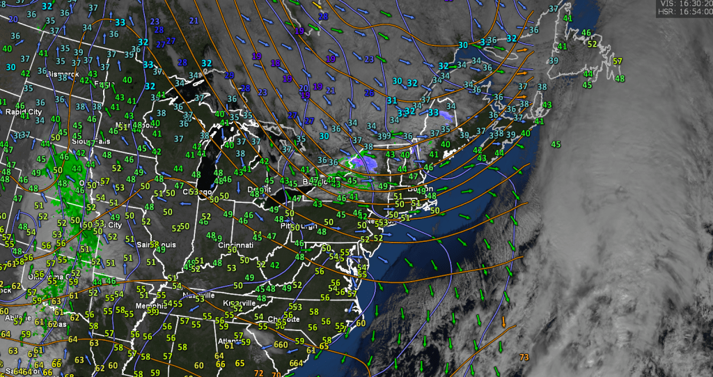
NWS compiled Cooperative Observer reports from Monday morning showing the Greensboro area with the most snow that fell Sunday night into early Monday before changing to rain showers.

Posted on November 28, 2023 by Weathering Heights
Posted in Quick Weather Updates

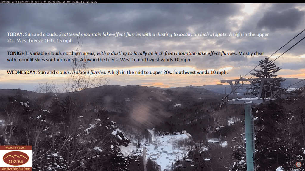
Lake Effect Flurries today, tonight, and lesser amounts Wednesday which may accrue to around an inch or so in some spots northern/central Green Mountains. Colder today, and tomorrow, then a nice uptick in temps.

Posted on November 28, 2023 by Weathering Heights
Posted in Quick Weather Updates

Heavy snows with power outages last night. Conditions have improved but it’ll be a slog to get power back on to everyone. Be patient. There are folks on it.

Posted on November 27, 2023 by Weathering Heights
Posted in Quick Weather Updates

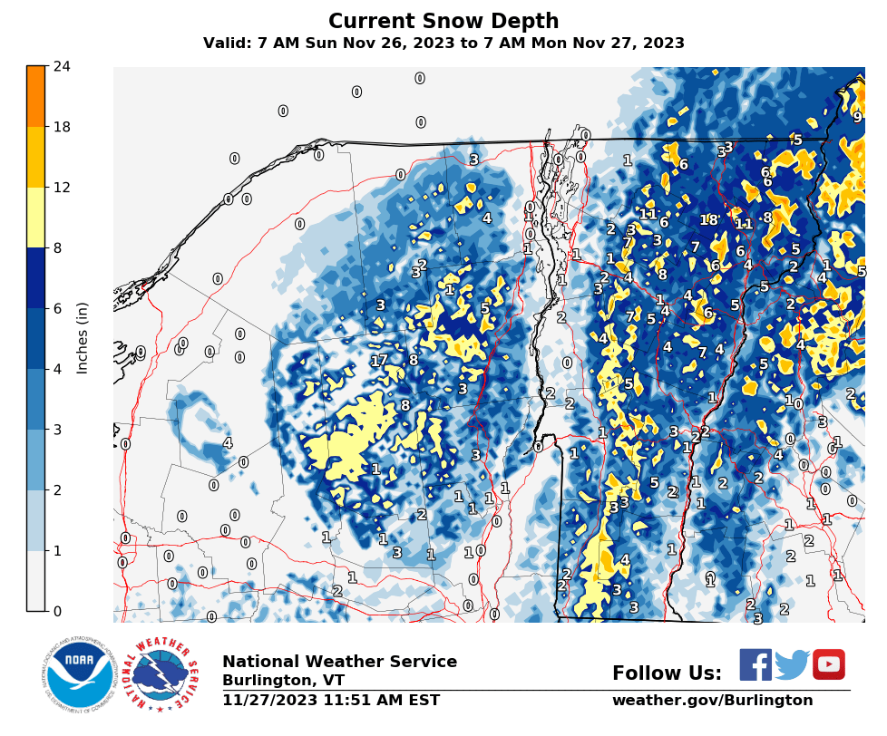
Storm pulling away with scattered rain showers and threats of additional snowfall is done. Healthy – yes! Greater than 1 Foot amounts of heavy wet snow. Over 30,000 without power but conditions to improve with a later high at least mid-30s and more like lower 40s valleys.

Posted on November 27, 2023 by Weathering Heights
Posted in Quick Weather Updates

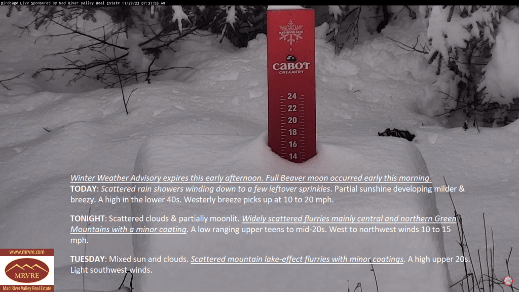
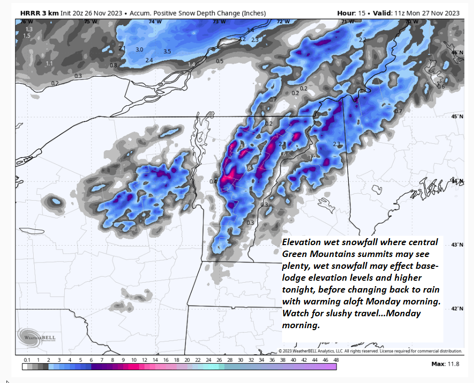
Elevation wet snowfall, & pretty healthy in the higher elevations, but much less to none valley floors with very marginal cold enough temperatures playing an altitude role. All rain before 8 AM…as warmth pushes in aloft.

Posted on November 26, 2023 by Weathering Heights
Posted in Quick Weather Updates

Flurries with a few sprinkles this morning could make for a couple icy spots on area roads, as temperatures “fall” into the middle 20s today on a cold northwest wind.

Posted on November 24, 2023 by Weathering Heights
Posted in Quick Weather Updates

Intervals of sun after a cloudy morning but clouds predominate with more sprinkles/flurries tonight. A sharply colder airmass arrives in northern Vermont Friday morning with downward temperature trends. Single digits Friday night some locations.

Posted on November 23, 2023 by Weathering Heights
Posted in Quick Weather Updates

Incoming travel issues begin as snow pushes in later this evening, with a wintry mix eventually going over to rain showers. A couple/few inches of snow will be wet and slushy, the most eastern areas especially Windsor-Windham counties

Posted on November 21, 2023 by Weathering Heights
Posted in Quick Weather Updates

Utility Outlook for Vermont — valid rest of Sunday into Friday November 24th, 2023.

Posted on November 19, 2023 by Weathering Heights
Posted in Quick Weather Updates

Post navigation

← Older posts
Newer posts→
Top 100 Weather Blog

Weathering Heights is a Feedspot Top 100 Weather Blog

Climate Reanalyzer

Tools to Visualize Climate and Weather Forecast Models

Daily Climate Maps updated 10:30 AM (courtesy of NWS Burlington VT)

Daily Climate Maps courtesy NWS-Burlington

forecast condition a few hours from now

forecast condition a few hours from now...

Precipitation amount forecast today

Precipitation amount forecast today

Recent earthquakes

Recent earthquakes

30 day observation precipitation graph Burlington VT

30 day observation precipitation graph Burlington VT

Link to Burlington 90 precipitation plot

90 day observation precipitation graph Burlington VT

River Check

Northeast River Forecast Center

Sun - current solar activity

Sun - Current Solar Activity

My Tweets

Climate Notes

Web cam from Weathering Heights in Worcester, Vermont, looking south toward Montpelier

Weathering Heights Web Cam, looking south toward Montpelier and uptown Berlin (refresh browser to update)

Plymouth State Radar

Plymouth State Radar

Current northeast U.S. infrared and visual satellite

Road Conditions

VTrans Road Conditions

Flight Delays

Flight delays

link to www.co2.earth

CO2.earth

Current Arctic Ice

link to 3 to 7 day upcoming weather hazards

3 to 7 day upcoming Weather Hazards

Follow Weathering Heights, Roger Hill's weather forecasting service on WordPress.com
Plymouth State Radar

Plymouth State Radar

Blog at WordPress.com.
Weathering Heights, Roger Hill's weather forecasting service
Blog at WordPress.com.
  • Subscribe Subscribed
    • Weathering Heights, Roger Hill's weather forecasting service
    • Join 132 other subscribers
    • Already have a WordPress.com account? Log in now.
    • Weathering Heights, Roger Hill's weather forecasting service
    • Subscribe Subscribed
    • Sign up
    • Log in
    • Report this content
    • View site in Reader
    • Manage subscriptions
    • Collapse this bar
 

Loading Comments...