Weathering Heights, Roger Hill's weather forecasting service

Weathering Heights, Roger Hill's weather forecasting service

Menu

Skip to content
  • Home
  • About Roger Hill
  • Quick Weather Updates

Category Archives: Quick Weather Updates

Quick, short updates

Post navigation

← Older posts
Newer posts→

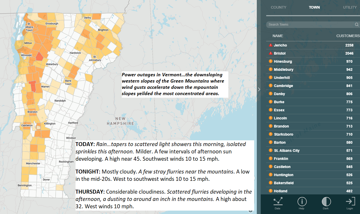
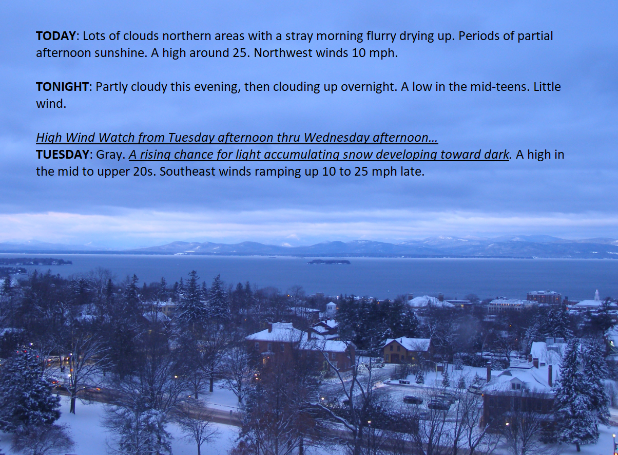
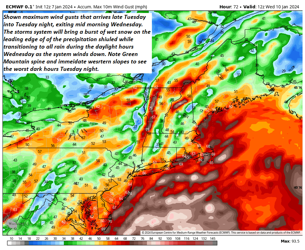
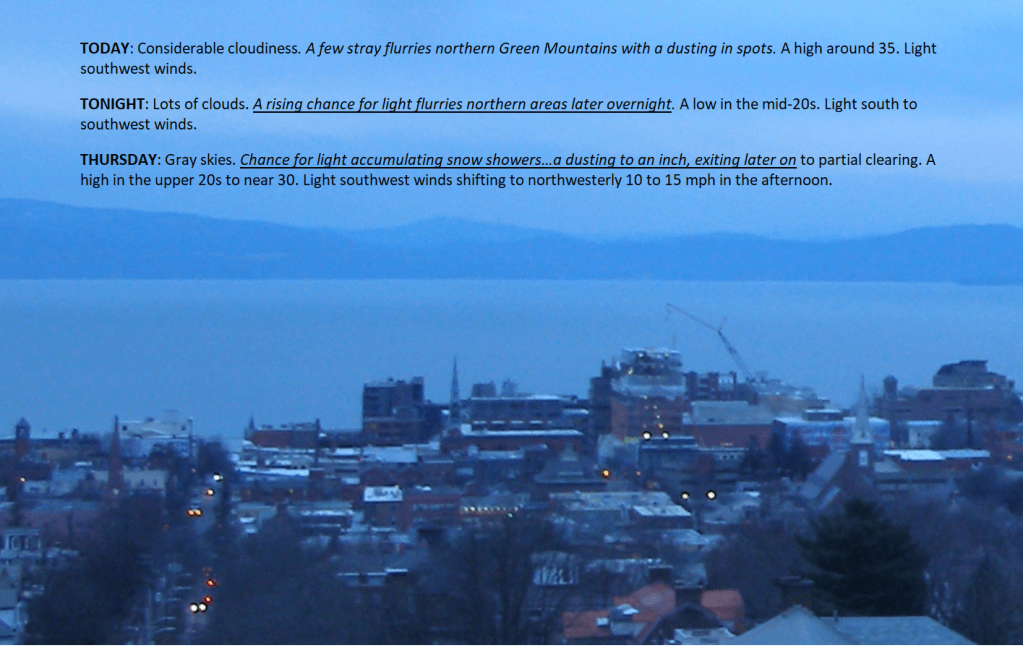
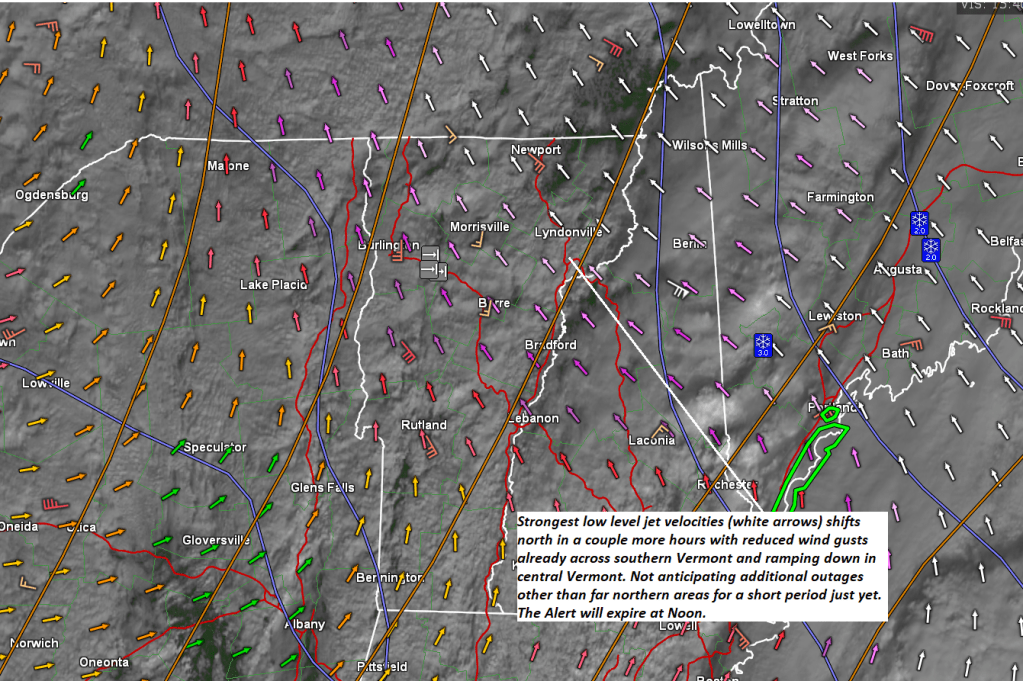
The second round of strongest wind gusts was beginning to push out of the region, but still very gusty Northeast Kingdom into the northern Champlain Valley. Rain showers…occasionally mixed with wet snowflakes to be the rule later today with light snow showers/flurries tonight.

Posted on January 13, 2024 by Weathering Heights
Posted in Quick Weather Updates

Minor coating of snow later today into the evening, before a better day Friday. Decent amounts of sunshine are anticipated after some morning clouds. Attention being paid to the next incoming storm – “High Wind Watches” up for western slopes of the Greens.

Posted on January 11, 2024 by Weathering Heights
Posted in Quick Weather Updates

Wind damage galore lived up to expectations especially the western slopes of the Green Mountains extending onto the valley floors…east of the Green Mountains wet snow and wind combined effects for more widely scattered outages.

Posted on January 10, 2024 by Weathering Heights
Posted in Quick Weather Updates

A significant storm system to rake the region with strong gusty southeasterly winds, a burst of heavy wet snow, and a transition to rain tonight. Milder showery weather Wednesday as highs hit the low and mid-40s. Numerous warnings and advisories. Power outages developing tonight…

Posted on January 9, 2024 by Weathering Heights
Posted in Quick Weather Updates

Enjoy what you can with our latest powder snowfall over the weekend. A nasty storm arrives late Tuesday into Wednesday morning with high winds fairly certain. The transition from wet snow to rain, another system could repeat Saturday.

Posted on January 8, 2024 by Weathering Heights
Posted in Quick Weather Updates

Folks might want to start prepping for what continues to look like one of our nastier storms. It does not arrive until Tuesday evening or so. Wet snow transitions to rain but it’s the winds that look worst.

Posted on January 7, 2024 by Weathering Heights
Posted in Quick Weather Updates

Light snows spread northeast Saturday evening and picks up Sunday with some nice powder falling in the southern Green Mountains and adjacent Berkshires, southern New Hampshire.

Posted on January 5, 2024 by Weathering Heights

Posted in Quick Weather Updates

An arctic cold front was moving through the Green Mountain State with scattered snow showers and a dusting to about an inch. Good news we should break into partial or more sunshine this afternoon. Temp’s peak this morning then gradually fall.

Posted on January 4, 2024 by Weathering Heights
Posted in Quick Weather Updates

Snowless downtown Burlington is shown with ice-free Lake Champlain. Most of the Great Lakes were ice-free with only 0.2 % ice cover on Lake Superior. This means the lakes will be open for business going into February for “lake effect” snowfalls in the future when we get frigid air.

Posted on January 3, 2024 by Weathering Heights
Posted in Quick Weather Updates

Courtesy of Judah Cohen & AER shows pathetic snow accrual across the U.S. and portions of Europe. Where there are minima, there are maxima, with heavy snow cover across Siberia, portions of Alaska across northern Canada to Labrador…

Posted on January 3, 2024 by Weathering Heights
Posted in Quick Weather Updates

Post navigation

← Older posts
Newer posts→
Top 100 Weather Blog

Weathering Heights is a Feedspot Top 100 Weather Blog

Climate Reanalyzer

Tools to Visualize Climate and Weather Forecast Models

Daily Climate Maps updated 10:30 AM (courtesy of NWS Burlington VT)

Daily Climate Maps courtesy NWS-Burlington

forecast condition a few hours from now

forecast condition a few hours from now...

Precipitation amount forecast today

Precipitation amount forecast today

Recent earthquakes

Recent earthquakes

30 day observation precipitation graph Burlington VT

30 day observation precipitation graph Burlington VT

Link to Burlington 90 precipitation plot

90 day observation precipitation graph Burlington VT

River Check

Northeast River Forecast Center

Sun - current solar activity

Sun - Current Solar Activity

My Tweets

Climate Notes

Web cam from Weathering Heights in Worcester, Vermont, looking south toward Montpelier

Weathering Heights Web Cam, looking south toward Montpelier and uptown Berlin (refresh browser to update)

Plymouth State Radar

Plymouth State Radar

Current northeast U.S. infrared and visual satellite

Road Conditions

VTrans Road Conditions

Flight Delays

Flight delays

link to www.co2.earth

CO2.earth

Current Arctic Ice

link to 3 to 7 day upcoming weather hazards

3 to 7 day upcoming Weather Hazards

Follow Weathering Heights, Roger Hill's weather forecasting service on WordPress.com
Plymouth State Radar

Plymouth State Radar

Blog at WordPress.com.
Weathering Heights, Roger Hill's weather forecasting service
Blog at WordPress.com.
  • Subscribe Subscribed
    • Weathering Heights, Roger Hill's weather forecasting service
    • Join 132 other subscribers
    • Already have a WordPress.com account? Log in now.
    • Weathering Heights, Roger Hill's weather forecasting service
    • Subscribe Subscribed
    • Sign up
    • Log in
    • Report this content
    • View site in Reader
    • Manage subscriptions
    • Collapse this bar
 

Loading Comments...