Weathering Heights, Roger Hill's weather forecasting service

Weathering Heights, Roger Hill's weather forecasting service

Menu

Skip to content
  • Home
  • About Roger Hill
  • Quick Weather Updates

Category Archives: Quick Weather Updates

Quick, short updates

Post navigation

← Older posts
Newer posts→

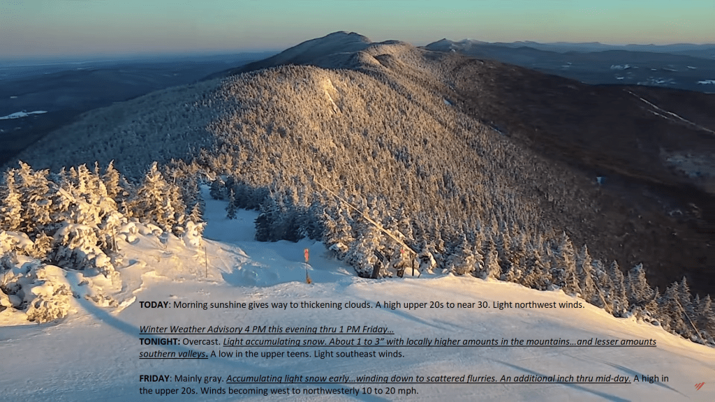
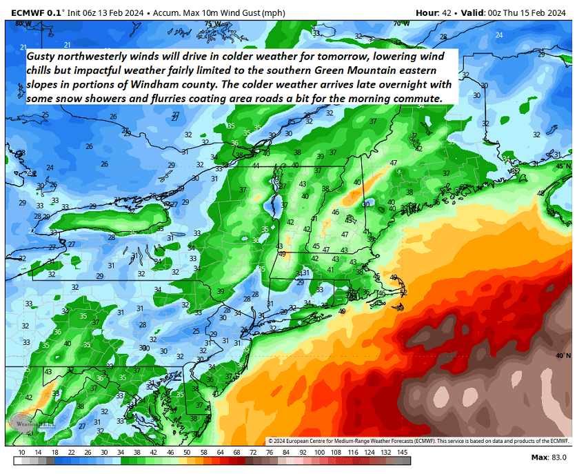
Lots of weather changes come through over the next 24 hours. A super mild air mass producing a few thunderstorms to our west will shift in later this morning. Snowmelt owed to the warm temperatures making stream and river rises in flood-prone areas. Gusty northwest winds drive in a big temperature drop with a shot of snow.

Posted on February 28, 2024 by Weathering Heights
Posted in Quick Weather Updates

An amazingly April-like day, well in the end of February. We could see some records broken, just like what has been occurring to our southwest. Clouds and sprinkle rain showers arrive this evening. Think snow melt and waterworks folks.

Posted on February 27, 2024 by Weathering Heights
Posted in Quick Weather Updates

Sunshine is on the increase but another cloudy band to move through with a rain or brief snow shower. Eventually, fully moonlit conditions tonight, setting up what could be the pick of the week tomorrow Tuesday.

Posted on February 26, 2024 by Weathering Heights
Posted in Quick Weather Updates

Changeable weather ahead with a milder day and eventually intervals of sunshine. An arctic front drops in with a significant cool down, before a bigger oscillation in temperature brings much milder conditions next week…which could lead to some flooding concerns.

Posted on February 23, 2024 by Weathering Heights
Posted in Quick Weather Updates

North American Daily Snowfall Extent.

Posted on February 20, 2024 by Weathering Heights
Posted in Quick Weather Updates

Cloudiness stretches east of Lake Huron Georgian Bay region all the way into Vermont. These clouds will make for more gray conditions while to the south, the sun will be shining brightly. The clouds push back into Canada tonight and tomorrow.

Posted on February 20, 2024 by Weathering Heights
Posted in Quick Weather Updates

Strong Jet stream aloft with reports of moderate to severe turbulence due likely to velocity shear, or the differences in layers of wind as aviation ascends and descends thru these layers. The seat belt sign was likely lit and those strapped in…

Posted on February 19, 2024 by Weathering Heights
Posted in Quick Weather Updates

Clipper system exits as flurries wind down today, but linger into Saturday for the mountains. Building snowpack just in time for Presidents Day Weekend with some new powder. Maple sugarers could get busy with sap runs in the middle of next week.

Posted on February 16, 2024 by Weathering Heights
Posted in Quick Weather Updates

Gorgeous morning in the Green Mountain State, with crisp conditions and clear skies looking north for near Lincoln Peak. Clouds were pushing east and will thicken up and lower this afternoon, with snow overspreading the region this evening, about 1 to 3″ overnight more in the mountains…

Posted on February 15, 2024 by Weathering Heights
Posted in Quick Weather Updates

Wind gusts shown below by the Euro model, usually the most accurate, will drive in some colder air for a mid-winter-like blast. Bundle up on Wednesday, you’ll feel it.

Posted on February 13, 2024 by Weathering Heights
Posted in Quick Weather Updates

Post navigation

← Older posts
Newer posts→
Top 100 Weather Blog

Weathering Heights is a Feedspot Top 100 Weather Blog

Climate Reanalyzer

Tools to Visualize Climate and Weather Forecast Models

Daily Climate Maps updated 10:30 AM (courtesy of NWS Burlington VT)

Daily Climate Maps courtesy NWS-Burlington

forecast condition a few hours from now

forecast condition a few hours from now...

Precipitation amount forecast today

Precipitation amount forecast today

Recent earthquakes

Recent earthquakes

30 day observation precipitation graph Burlington VT

30 day observation precipitation graph Burlington VT

Link to Burlington 90 precipitation plot

90 day observation precipitation graph Burlington VT

River Check

Northeast River Forecast Center

Sun - current solar activity

Sun - Current Solar Activity

My Tweets

Climate Notes

Web cam from Weathering Heights in Worcester, Vermont, looking south toward Montpelier

Weathering Heights Web Cam, looking south toward Montpelier and uptown Berlin (refresh browser to update)

Plymouth State Radar

Plymouth State Radar

Current northeast U.S. infrared and visual satellite

Road Conditions

VTrans Road Conditions

Flight Delays

Flight delays

link to www.co2.earth

CO2.earth

Current Arctic Ice

link to 3 to 7 day upcoming weather hazards

3 to 7 day upcoming Weather Hazards

Follow Weathering Heights, Roger Hill's weather forecasting service on WordPress.com
Plymouth State Radar

Plymouth State Radar

Blog at WordPress.com.
Weathering Heights, Roger Hill's weather forecasting service
Blog at WordPress.com.
  • Subscribe Subscribed
    • Weathering Heights, Roger Hill's weather forecasting service
    • Join 132 other subscribers
    • Already have a WordPress.com account? Log in now.
    • Weathering Heights, Roger Hill's weather forecasting service
    • Subscribe Subscribed
    • Sign up
    • Log in
    • Report this content
    • View site in Reader
    • Manage subscriptions
    • Collapse this bar
 

Loading Comments...