Weathering Heights, Roger Hill's weather forecasting service

Weathering Heights, Roger Hill's weather forecasting service

Menu

Skip to content
  • Home
  • About Roger Hill
  • Quick Weather Updates

Category Archives: Quick Weather Updates

Quick, short updates

Post navigation

← Older posts
Newer posts→

Outstanding morning sun as the #fog layer lifts while mid-level clouds push along. We have a nice warming trend ahead…but #frosty/foggy possible rime and even a few advancing #sprinkles could make of the odd “slick spot” next couple of hours…so watch it!

Posted on October 24, 2023 by Weathering Heights
Posted in Quick Weather Updates

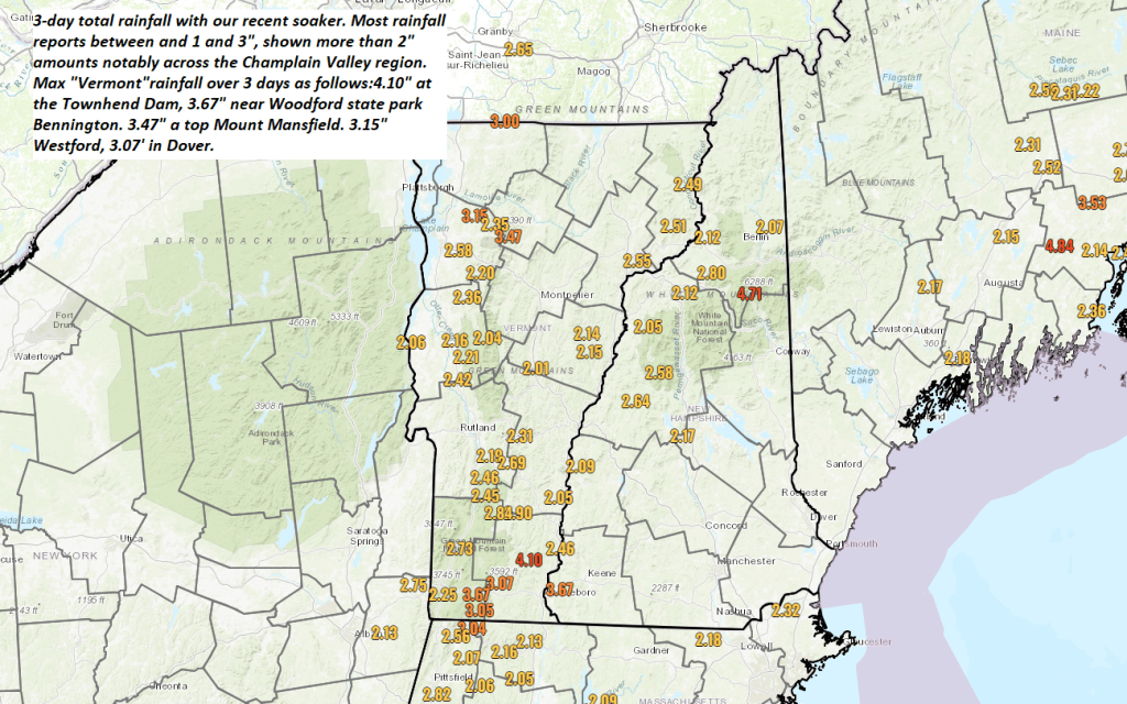
Healthy soaker with from about 1 to over 3 inches had fallen over the last 3 days ending this Monday morning here in the #GreenMountainState. Drier trends ahead…

Posted on October 23, 2023 by Weathering Heights
Posted in Quick Weather Updates

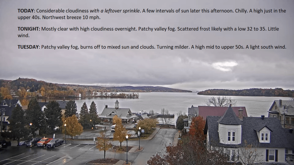
Transition Day from a little drizzle/sprinkles in the northern Green Mountains…into breaks of sunshine and eventually intervals of sun by later today. A drying trend and warmer conditions much of the work week, exceptions right along portions of far northern Vermont…

Posted on October 23, 2023 by Weathering Heights
Posted in Quick Weather Updates

Take it with a grain…but we should have some inroads in the “first snows” department. Over the next 15 days, see the difference between now (well below normal, if not record setting low) to snowfall that reaches into the northern tier and all of Canada

Posted on October 20, 2023 by Weathering Heights
Posted in Quick Weather Updates

Moderate to possibly heavy rain event on the way arriving from the south this afternoon. Clear out clogged drains of leaves as from 1 to potentially 3 inch amounts fall this afternoon thru Sunday evening. Next dry weather days Monday & Tuesday…

Posted on October 20, 2023 by Weathering Heights
Posted in Quick Weather Updates

Color in them thar hill holds on looking southwest across Middlesex and into the distant Mad River Vally and Green Mountains.

Posted on October 19, 2023 by Weathering Heights
Posted in Quick Weather Updates

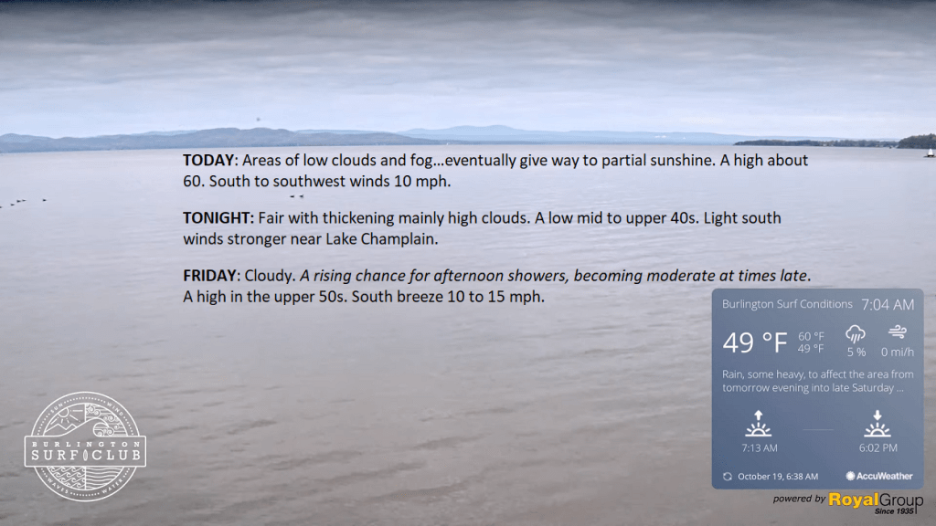
Stubborn cloud layers not yet pushing out will mar what could have been increasing sunny trends, but eventually, though it may take a long while. Enjoy today, wet weather arrives Friday afternoon, and sets up what looks like an “indoor weekend”

Posted on October 19, 2023 by Weathering Heights
Posted in Quick Weather Updates

Drab gray weather transitions toward intervals of sunshine today. Better conditions on Thursday. These slow changes also won’t last long, so make the most of it.

Posted on October 18, 2023 by Weathering Heights
Posted in Quick Weather Updates

Antarctic Rapid Warming

Posted on October 17, 2023 by Weathering Heights
With most of the attention on the Northern Hemisphere, Polar Amplification in the southern hemisphere was garnering the appropriate attention. Yes, things are changing fast down-under.
Posted in Quick Weather Updates

Still seeing pockets of decent color as we are just around the corner of “#StickSeason” and that Halloween look to our landscape, but still kind of pretty just yet.

Posted on October 17, 2023 by Weathering Heights
Posted in Quick Weather Updates

Post navigation

← Older posts
Newer posts→
Top 100 Weather Blog

Weathering Heights is a Feedspot Top 100 Weather Blog

Climate Reanalyzer

Tools to Visualize Climate and Weather Forecast Models

Daily Climate Maps updated 10:30 AM (courtesy of NWS Burlington VT)

Daily Climate Maps courtesy NWS-Burlington

forecast condition a few hours from now

forecast condition a few hours from now...

Precipitation amount forecast today

Precipitation amount forecast today

Recent earthquakes

Recent earthquakes

30 day observation precipitation graph Burlington VT

30 day observation precipitation graph Burlington VT

Link to Burlington 90 precipitation plot

90 day observation precipitation graph Burlington VT

River Check

Northeast River Forecast Center

Sun - current solar activity

Sun - Current Solar Activity

My Tweets

Climate Notes

Web cam from Weathering Heights in Worcester, Vermont, looking south toward Montpelier

Weathering Heights Web Cam, looking south toward Montpelier and uptown Berlin (refresh browser to update)

Plymouth State Radar

Plymouth State Radar

Current northeast U.S. infrared and visual satellite

Road Conditions

VTrans Road Conditions

Flight Delays

Flight delays

link to www.co2.earth

CO2.earth

Current Arctic Ice

link to 3 to 7 day upcoming weather hazards

3 to 7 day upcoming Weather Hazards

Follow Weathering Heights, Roger Hill's weather forecasting service on WordPress.com
Plymouth State Radar

Plymouth State Radar

Blog at WordPress.com.
Weathering Heights, Roger Hill's weather forecasting service
Blog at WordPress.com.
  • Subscribe Subscribed
    • Weathering Heights, Roger Hill's weather forecasting service
    • Join 132 other subscribers
    • Already have a WordPress.com account? Log in now.
    • Weathering Heights, Roger Hill's weather forecasting service
    • Subscribe Subscribed
    • Sign up
    • Log in
    • Report this content
    • View site in Reader
    • Manage subscriptions
    • Collapse this bar
 

Loading Comments...