Weathering Heights, Roger Hill's weather forecasting service

Weathering Heights, Roger Hill's weather forecasting service

Menu

Skip to content
  • Home
  • About Roger Hill
  • Quick Weather Updates

Category Archives: Quick Weather Updates

Quick, short updates

Post navigation

← Older posts

Gorgeous Sunrise alert. Grab your phone’s early risers.

Posted on April 18, 2024 by Weathering Heights
Posted in Quick Weather Updates

A bit of overlapping seasons with strong gusty south to southeasterly gusts (typically found in the Fall and Winter months) and some potential boomers with a last potent shot of showers and a few embedded thunderstorms late today. The two-season combo, brought to us courtesy of a deepening low pressure system near the Great Lakes. Gradual improvement over the weekend but colder.

Posted on April 12, 2024 by Weathering Heights
Posted in Quick Weather Updates

Drip-Drip-Drip Weather. Watch for the possibility of Spotted #SalamanderMigration to vernal ponds and water holes especially on milder & wet April nights. The dreary damp weather to continue for the foreseeable future with a turning point not until Sunday or Monday.

Posted on April 11, 2024 by Weathering Heights
Posted in Quick Weather Updates

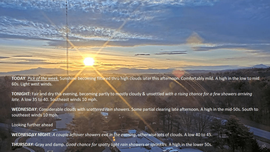
Beautiful morning in progress. Mid level altocumulus will track out of the region setting up lots of sun before more high thin cirrus work back into the region this afternoon. We turn the corner of sorts with cloudier and unsettled wetter weather tonight and beyond, so make the most of it.

Posted on April 9, 2024 by Weathering Heights
Posted in Quick Weather Updates

Drone time lapse easily seen moon shadow crossing thru Vermont on the thin veil of Cirrus. Pretty damn cool. Use all you want – Credit Weathering Heights Worcester Vermont.

Posted on April 8, 2024 by Weathering Heights
Posted in Quick Weather Updates

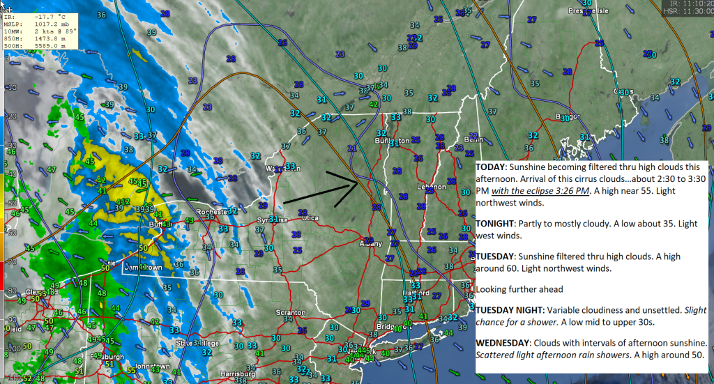
Current Infrared showing some high thin Cirrus clouds working gradually eastward across portions of New York into Vermont. Not perfect but still pretty decent conditions for the total Solar eclipse at 3:26 PM this Monday afternoon. Decent weather follows tomorrow even a little warmer.

Posted on April 8, 2024 by Weathering Heights
Posted in Quick Weather Updates

Nor’easter near Nantucket will curl northeast today and tonight into the Gulf of Maine with additional wet snowfall for a time this morning but lightening up and perhaps even intermittent some parts of Vermont this afternoon. Gradually the low pressure system will loop and pull away but not for a couple of more days.

Posted on April 4, 2024 by Weathering Heights
Posted in Quick Weather Updates

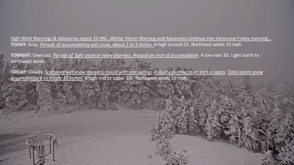
Enjoy what may be the last sunshine you’ll see between tonight and Sunday. A big storm system bringing high winds, and wet heavy snows will gradually develop over the next 12 to 24 hours while spreading north tomorrow. Estimated total snow accumulations of plowable 5 to locally 13″ of winter wonderland look, coming out of “dead-stick season” to a different look.

Posted on April 2, 2024 by Weathering Heights
Posted in Quick Weather Updates

Below cloud climatology for this time of year, vs. Euro model forecast showing mostly sunny skies, and high thin Cirrus/Cirrostratus clouds about all. This is the longer range forecast and yes it still could change, but feeling rather optimistic with decent sprawling area of high pressure over the region.

Posted on April 1, 2024 by Weathering Heights
Posted in Quick Weather Updates

Mid and high clouds to allow for some sunny periods mixing in today, and just high thinner clouds Tuesday making for a couple real nice days in the Green Mountain State. Major storm system affects the region later in the week, with wet snow mixed with rain valleys, and high winds interacting with terrain central and southern Vermont.

Posted on April 1, 2024 by Weathering Heights
Posted in Quick Weather Updates

Post navigation

← Older posts
Top 100 Weather Blog

Weathering Heights is a Feedspot Top 100 Weather Blog

Climate Reanalyzer

Tools to Visualize Climate and Weather Forecast Models

Daily Climate Maps updated 10:30 AM (courtesy of NWS Burlington VT)

Daily Climate Maps courtesy NWS-Burlington

forecast condition a few hours from now

forecast condition a few hours from now...

Precipitation amount forecast today

Precipitation amount forecast today

Recent earthquakes

Recent earthquakes

30 day observation precipitation graph Burlington VT

30 day observation precipitation graph Burlington VT

Link to Burlington 90 precipitation plot

90 day observation precipitation graph Burlington VT

River Check

Northeast River Forecast Center

Sun - current solar activity

Sun - Current Solar Activity

My Tweets

Climate Notes

Web cam from Weathering Heights in Worcester, Vermont, looking south toward Montpelier

Weathering Heights Web Cam, looking south toward Montpelier and uptown Berlin (refresh browser to update)

Plymouth State Radar

Plymouth State Radar

Current northeast U.S. infrared and visual satellite

Road Conditions

VTrans Road Conditions

Flight Delays

Flight delays

link to www.co2.earth

CO2.earth

Current Arctic Ice

link to 3 to 7 day upcoming weather hazards

3 to 7 day upcoming Weather Hazards

Follow Weathering Heights, Roger Hill's weather forecasting service on WordPress.com
Plymouth State Radar

Plymouth State Radar

Blog at WordPress.com.
Weathering Heights, Roger Hill's weather forecasting service
Blog at WordPress.com.
  • Subscribe Subscribed
    • Weathering Heights, Roger Hill's weather forecasting service
    • Join 127 other subscribers
    • Already have a WordPress.com account? Log in now.
    • Weathering Heights, Roger Hill's weather forecasting service
    • Subscribe Subscribed
    • Sign up
    • Log in
    • Report this content
    • View site in Reader
    • Manage subscriptions
    • Collapse this bar
 

Loading Comments...