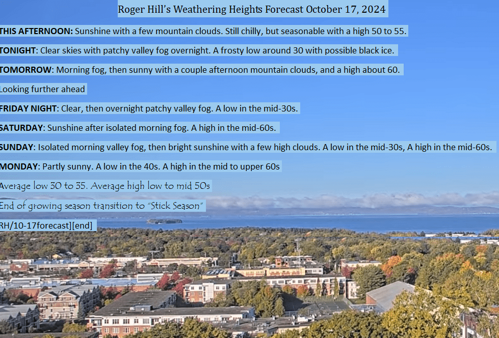
Forecast thru Monday the 21st.


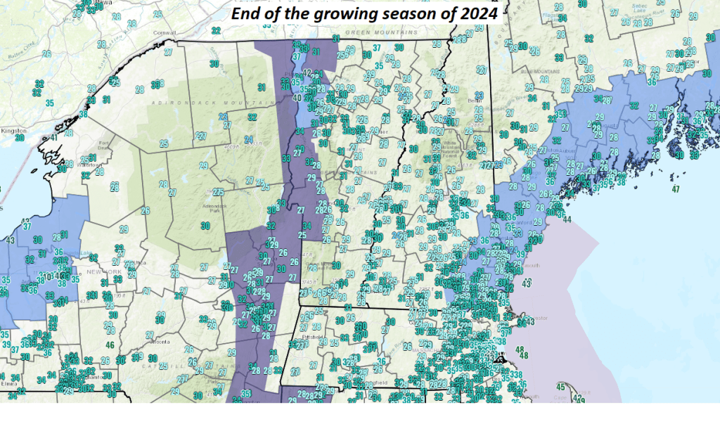
Temperatures have crossed below freezing in just about every location early this morning after a fairly significant chill down arrived a few days ago, and subsidence under high pressure to our west reached the Northeast and New England with clearing skies last night and a free-fall in diurnal temperatures overnight. More frost was possible but overall a warming trend will bring back some of that early Autumn weather, with very dry conditions setting up again.
Weather trends from the current dreariness and some recent higher terrain snowfall to improve with increasingly sunny days, a milder trend possibly into the lower 70s for highs followed by some brief cool downs again but main active part of the jet stream advances north back into Canada.
The jet stream energy lifting northward also related to what is developing with the circumpolar vortex as a stronger (AO) arctic oscillation signal. This temporarily keeps the arctic air bottled up and does not dip down into the U.S. as strongly.
The net effects are milder conditions but still oscillating some to colder weather now and then, but largely above normal in temperature for most of the last half of October. Nothing certain here, but these are the trends.
Overall, I’m still seeing a weaker than normal start to our winter for the months of November and December, with a more back-loaded winter after the holidays ahead.
La Nina plus overheating from fossil fuel burning the main drivers controlling our weather.
10-11 Active weather for mid-October courtesy of the northern branch of the jet stream and slightly more vigorous upper level short waves blasting on thru for what will may be picturesque – partly cloudy unsettled conditions at at times some blasts of wind from the northeast.
Gusty winds will likely change-up the landscape of northern New England stripping leaves off the trees in bulk and ending fall foliage to a transition to stick season.
Blustery conditions bring in slightly colder temperatures aloft heading into early next week, with a few dust-ups from mixed rain showers and wet snow flakes.
I do not see travel issues yet, but it’s a reminder about the annual changeover to winter tires especially those who traverse higher terrain in northern and central Vermont.
Wind gusts that exceed 40 mph, with mostly marginally strong gusts from the northwest affecting mountain tops and slopes of the eastern Green’s will be in play for a few power hits, but nothing extraordinary this weekend.
Leaves will be a flyin….
Watching from afar, up here in Vermont, Florida residents need to get out in those specific locations as recommended by the local NWS offices and heed all warnings as a catastrophic hurricane will cross the central portion of Florida.
Steering tracks indicate a nice tight projection somewhere a little south of Tampa Bay while Hurricane Milton was expected to encounter some shear aloft and velocity loss while arriving. However, this is NO COMFORT as the hurricane will be devastating with storm surge, catastrophic winds, waves, and especially the right front quad of the storm with its storm surge expected to be deadly based on the latest tracks, though if passing south of Tampa Bay – this would be better case scenario. And a northern track worst…with deadly storm surge into the Bay in a highly populated area. This makes Milton potentially extremely deadly.
Other considerations: !00% ground saturation recent wet weather and effects from sideswiping “Helene” likely to cause extra up-rooting of trees. Also deadly missiles of destruction where debris to be picked up and slammed. Milton likely to be another historical storm.
Heed all warnings and evacuations as this will not be survivable on the coast. Ignore some of the mutterings by some that do not follow the official Hurricane Center guidance and especially the local National Weather Service Offices in the storm-bound areas.
In Vermont get ready for a little frost where temperatures should be straddling in the low to mid 30s but colder right on the ground.
Valley fog and some touch of frost likely this morning in the coldest locations this Sunday early October morning.
Nice cooler day ahead after the morning chill and fog burns off. Some cloudiness arrives from the northwest with a weak frontal boundary and colder air on light breezes pushes in. This sets the stage for temperatures below normal.
And, we appear to be on track for a few mountain dust-ups of the first snowfall in the highest elevations of the Greens. Leaf-fall in progress likely to be helped along by raindrops tonight into tomorrow. Additionally, cloud cover to linger on some.
Florida is under the gun for TS. Milton powering up into a cat. 2,3 hurricane per latest Hurricane Center projections with an odder west-to-east steering flow making for yet another Gulf side landfall vicinity of Tampa Bay midweek.
About that time, some of the coldest air aloft will have arrived lowering the snowline onto local mountain tops with potential dust-ups for snow without travel issues as rain drops predominate, but mixed with snow pellets at higher elevations. The next video will cover this first snowfall in our ski resorts’ higher terrain.
Septembers anecdotally across northern New England and upstate New York, have really been nice generally above normal than recent baselines, drier than normal, and frequently seeing drier than normal conditions, making outdoor events really sparkle. The dry mild conditions have come due to blocking high-pressure systems keeping clouds and rainfall at bay.
The one major rainfall occurred with a slow-moving frontal system on the 25th, and 26th. 2.47” of rainfall — a decent soaker brought up local streams and rivers from rocky trickles, but did not flood or cause washouts.
Temperatures were largely above normal but without extremes. “Weather-tainment” values (my new category for those who follow closely) in the Green Mountain state were largely absent, with impulses moving through weak and generally fading as they approached the Green Mountain State. Wind gusts were limited. This may mean the next more marginal windy day, may see more trees come down than usual.
Fall color was drabber in my opinion, but pockets of vivid reds, yellows, and oranges were out there with “leaf-peepers more in search. With a big dry stretch from the 10th, through the 24th, some tree species were sufficiently dried out as to have crinkled leaves, but the main sugar maples were still doing their thing. Flying insects were happiest with more wasps than usual.
Many days saw sunshine after morning fogs in the valleys, below the typical temperature inversions setting up about 1300 ft MSL. Weather hazards were practically nil.
The projection for the first half of October are more active though gradually, but overall milder, and opportunities for precipitation come at us in the Northern New England region fading with the default position of higher pressure over the Northeast U.S.
However, a more normal weather pattern eventually kicks in with more frequent opportunities for light amounts of precipitation in the form of rain.
Across the mountain tops of northern New England, we see increasing chances for a little dusting of snow where temperatures aloft barely get cold enough.
As the weather pattern may change up to one more average after the first week of October, there will be more partly sunny to sunny days in between frontal passages. Overall, a slow start to the cold season is anticipated, and lower than average snowfall for the northeast, with the active weather favoring western Canada into parts of the interior of the west.