
Author Archives: weatheringheights1
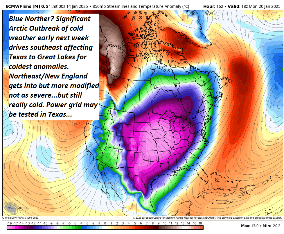
Feelin quite cold in southern Trumpistan with all that cold arctic air that our “free” Canadian neighbors sent southward. But whatcha gonna do? Ban cold air? Rename it? Pretend it doesn’t exist? GFY’s
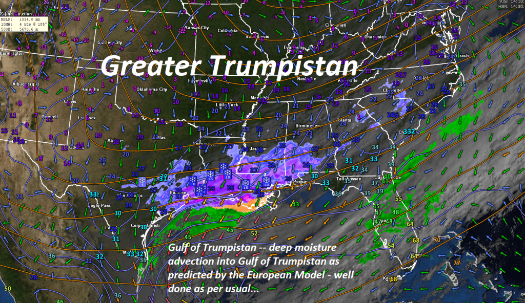
High latitude blocking forces arctic air southeast especially through the Rockies and Plains ending up in mid-section of the nation early next week. Shown – modelled for Monday Afternoon.
Mid January Synoptic Meteorology
What happens in droughty dry conditions, even in suburban areas, with excessively strong Santa Ana (katabatic) winds. All you need is a spark and its off to extreme combustion. Super tragic for NW. Los Angeles area.

Cold northwesterly flow steered around Maritime low pressure without much change over the next 54 hours or so. Most of it NW. Vermont upsloping locations where Winter Winter Advisory continues. Not much change ahead. Weather pattern “Locked In”

Roger Hill’s Radio Vermont Forecast 3:00 PM Tuesday 1-6-25
Winter Weather Advisory continues thru late Wednesday eastern Chittenden, Lamoille, and Franklin Counties.
TONIGHT: Cloudy. Occasional light accumulating snow showers or flurries. Dusting to an inch northern Greens. A low 5 to 10. Northwest winds 10 to 15 mph lowering wind chills.
TOMORROW: Gray. Scattered lingering snow showers or flurries, mainly northern mountains. Dusting to an inch northern Greens. Well below normal in temperature. A high just upper single digits. Northwest winds 10 to 20 mph lowering wind chills.
WEDNESDAY NIGHT: Overcast. Scattered lingering snow showers or flurries especially northern areas. Minor accumulation. Little change in temperature.A low around 5 above. Northwest winds 10 to 15 mph.
THURSDAY: Lots of clouds. Scattered lingering snow showers or flurries especially northern areas. Dusting to an inch northern Greens. Not as cold. A high in the mid to upper teens. Northwest winds 10 to 20 mph.
Looking further ahead
THURSDAY NIGHT: Mostly cloudy. A few flurries near the mountains. A low 10 to 15.
FRIDAY: Maybe a stray morning flurry, then breaks of sunshine. A high about 20.
SATURDAY: Predominantly gray. Chance for light spotty accumulating snow or flurries developing. Minor accumulation. A low around 10. A high 20 to 25.
SUNDAY: Maybe an early flurry, otherwise lingering clouds. A low 10 to 15. A high near 25. (to feel like a mild day)
Average low ranging thru the single digits. Average high mid-20s to near 30.
Full Wolf Moon Monday 1-13-25 at 5:27 PM
Peak Meteorological Winter 1-23-25
RH/1-7-25forecast][end]
Some intervals of sun a bonus today, but we are back to more clouds as depicted below right above Vermont. A more substantial weather system tracks by to our south, with no affects…

Roger Hill’s Radio Vermont forecast 3:00 PM Monday 1-6-25
Winter Weather Advisory overnight thru late Wednesday northern Green Mountains
TONIGHT: Scattered clouds this evening then clouding up. Rising chance for light snow showers or flurries developing far northern areas with light coatings.Frigid.An evening low around zero to 5 above. Northwest winds 10 mph lowering wind chills.
TOMORROW: Considerable cloudiness. Occasional light accumulating snow showers or flurries especially northern areas. Dusting to an inch or two northern Greens. A high around 15. Northwest winds 10 to 20 mph lowering wind chills.
TUESDAY NIGHT: Cloudy. Occasional light accumulating snow showers or flurries. Dusting to an inch or two northern Greens. Frigid. A low around 5 above. Northwest winds 10 to 15 mph lowering wind chills.
WEDNESDAY: Predominantly gray. Scattered lingering snow showers or flurries, mainly northern mountains. Dusting to an inch northern Greens. Well below normal in temperature. A high just 5 to 10 above. Northwest winds 10 to 20 mph lowering wind chills.
Looking further ahead
WEDNESDAY NIGHT: Overcast. Scattered lingering snow showers or flurries especially northern areas. Minor accumulation. A low around 5 above.
THURSDAY: Mostly cloudy. Scattered lingering snow showers or flurries, especially northern areas. Minor accumulation. Not as cold. Slight warming trend. A high 15 to 20.
FRIDAY: Maybe a stray morning flurry with a dusting, then intervals of sunshine. A low 10 to 15. A high near 20.
Average low ranging thru the single digits. Average high mid-20s to near 30.
Full Wolf Moon Monday 1-13-25 at 5:27 PM
Peak Meteorological Winter 1-23-25
RH/1-6-25forecast][end]
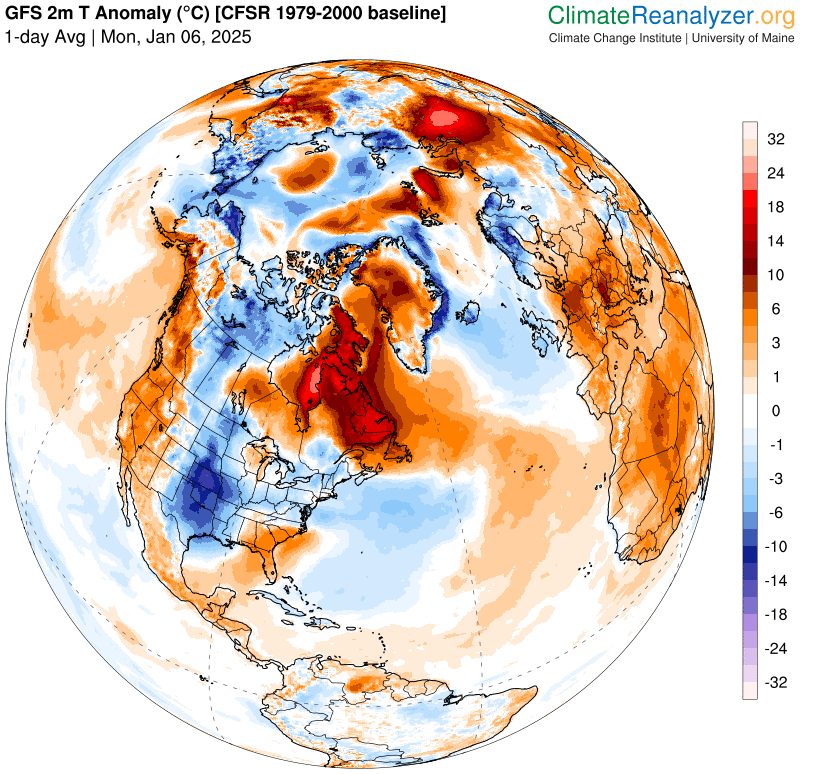
Monday morning (1-6) anomaly in temperature as compared to average climatology.
Across the pond – UK snow. 1-6-25
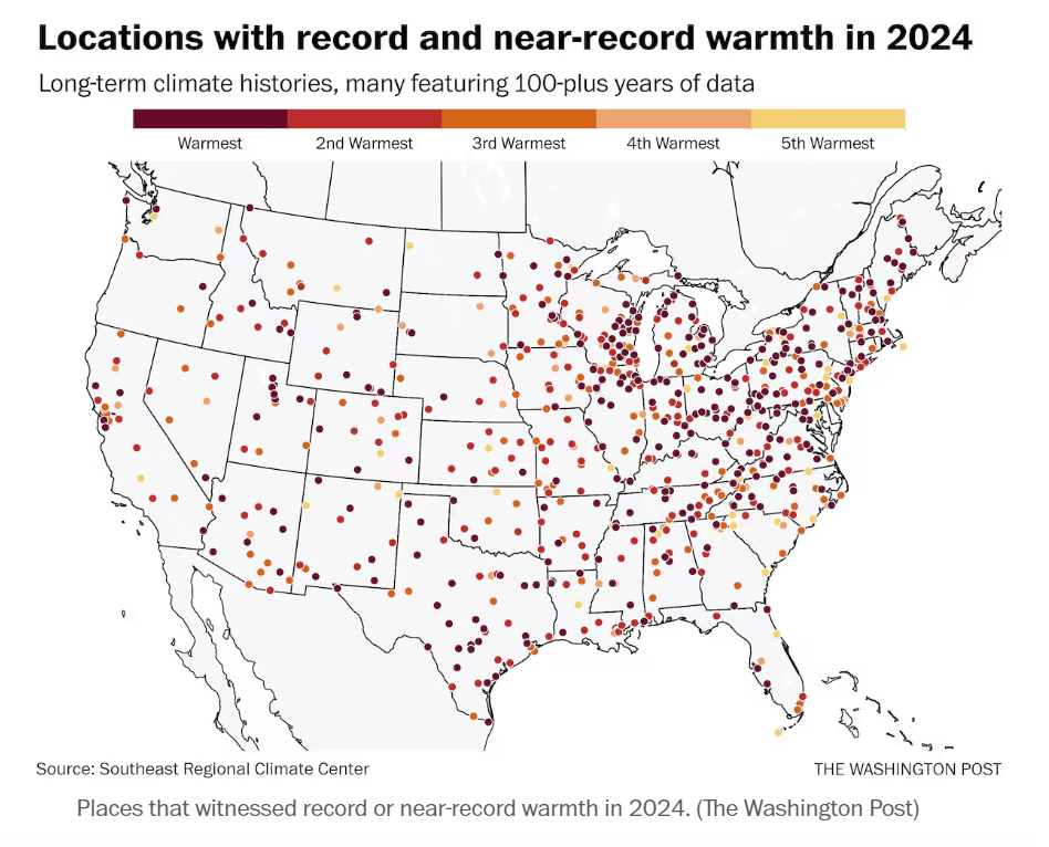
What do you notice right off…its not that it’s regional but fairly widespread, Midwest, into the Northeast seeing the most. But, there are no cold records. This is not being picked up much by the Mainstream Media, or otherwise, and some are frankly “omitting” this information. This is when politics and science collide – and it appears that an overheating planet – is now POLITICALLY CORRECT much like the state of Florida and their “Sunny day Flooding” due to sea level rise.
Note to all — Weather has now become so jointed with extreme right-wing politics, I fear data loss/omission is just starting. What next with MAGA NOAA – no “Heat Warnings/Advisories, omission of high-temperature records, and on and on due to the “political chill” of source GHG’s.
What have we become? How does this serve 99% of us? We are not even ready for the 20th of January yet. Politics at the federal level – is what I’ve experienced in my 50 plus years in meteorology 3 US Army, 12 NWS, but only much more subtly. Now it’s wide open, bought and paid for by oligarchy.
