Updated Friday Evening Forecast — June 24th, 2022

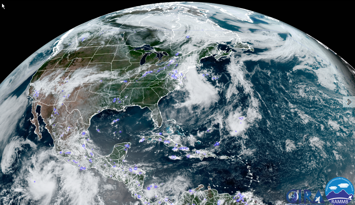
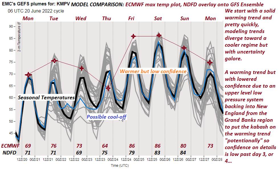
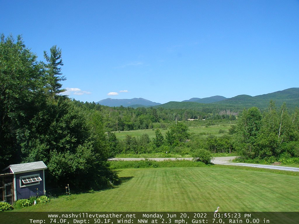
TONIGHT: Mostly clear with a few high clouds. Patchy valley fog. A low in the mid-50s. Light southwest winds.

TOMORROW: Mostly sunny with some high cloudiness. Muggy & warm. A high near 85. Light northwest breeze.

SATURDAY NIGHT: Fair, with high cloudiness and kind of muggy. A low about 60. Light east winds.

SUNDAY: Sunshine mixing with more clouds. Hot & and muggy. A high upper 80s pushing 90. South to southwest breeze 10 mph.

Looking further ahead…

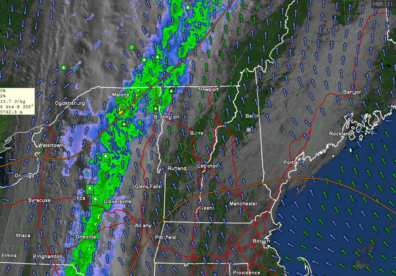
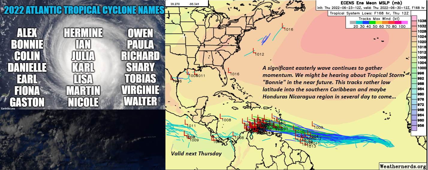
SUNDAY NIGHT: Fair in the evening but with thickening clouds. Showers likely after midnight moderate at times, with a rumble of thunder possible. A low mid 60s

MONDAY: Good chance for morning showers, some moderate at times early with a rumble of thunder. Periods of sunshine developing. Humid. A high 70 to 75.

TUESDAY: Morning fog burns off, then partly sunny. Cooler. A low in the low 50s. A high around 70.

WEDNESDAY: Mixed sun and clouds. A low near 50. A high 75 to 80.

Average lows low to mid-50s. Average highs in the mid to upper 70s.

RH/6-24[forecast][end]

Updated Friday Morning Forecast — June 24th, 2022

TODAY: A few sprinkles possible this morning, transitioning to increasing afternoon sun. Milder. A high mid to upper 70s. Winds becoming northwest 10 mph.

TONIGHT: Mostly clear with some high cloudiness. Patchy valley fog. A low in the mid-50s. Light winds.

SATURDAY: Mostly sunny, some high clouds. Muggy & warm. A high 80 to 85. Northwest winds 10 mph.

Looking further ahead…

SATURDAY NIGHT: Fair, with high cloudiness and kind of muggy. A low in the low 60s.

SUNDAY: More sun than clouds. Hot & and muggy. A high upper 80s pushing 90 degrees.

MONDAY: Mainly cloudy & humid. Good chance for showers with rumbles of thunder, some moderate to heavy at times…exiting later in the afternoon with partial sunshine. Humid. A low mid to upper 60s. A high in the low 70s.

TUESDAY: Morning fog, burns off then partly sunny. Cooler. A low in the low 50s. A high around 70.

WEDNESDAY: Mixed sun and clouds. A low near 50. A high 75 to 80.

Average lows low to mid-50s. Average highs in the mid to upper 70s.

RH/6-24[forecast][end]

Updated Thursday Evening Forecast — June 23rd, 2022

TONIGHT: Considerable cloudiness. Scattered showers. A low around 55. Light southeast winds.

TOMORROW: Scattered showers diminishing. Partial sunshine developing for the afternoon. Milder. A high mid to upper 70s. Northwest winds 10 mph.

FRIDAY NIGHT: Mostly clear. Patchy valley fog. A low mid to upper 50s. Light winds.

SATURDAY: Partly to mostly sunny. Muggy & warm. A high in the lower 80s. Northwest winds 10 mph.

Looking further ahead…

SATURDAY NIGHT: Fair with high cloudiness. A low around 60.

SUNDAY: Mixed sun and clouds. Warm and sticky. A high upper 80s to around 90 degrees.

MONDAY: Mainly cloudy. Chance for showers, maybe some rumbles of thunder. Rather humid. A low 65 to 70. A high in the low 70s.

TUESDAY: Morning fog, burns off then partly sunny. Cooler. A low in the low 50s. A high 65 to 70.

Average lows low to mid-50s. Average highs in the mid to upper 70s.

RH/6-23[forecast][end]

Updated Thursday Morning Weather — June 23rd, 2022

TODAY: Clouds with intervals of sun east of the Green Mountains. Overcast with frequent showers…moderate at times Champlain Valley and western Vermont. A high in the lower 70s but cooler in the 60s western Vermont. Southeast breeze

10 mph.

TONIGHT: Considerable cloudiness. Widely scattered showers. A low around 55. Light southeast winds.

FRIDAY: Scattered morning showers exiting in the afternoon with partial sunshine developing. Warmer, moderately humid. A high 75 to near 80. Light west winds.

Looking further ahead…

FRIDAY NIGHT: Mostly clear. Patchy valley fog. A low mid to upper 50s.

SATURDAY: A beauty. Lots of sunshine with a few afternoon clouds. Muggy & warm. A high in the lower 80s.

SUNDAY: Morning sun then afternoon clouds. Warm and sticky. A low About 60. A high pushing to near 90 degrees.

MONDAY: Mostly cloudy & sultry, Chance for showers, and a few thunderstorms, some possibly heavy and strong. A low mid to upper 60s. An early high in the low to mid 70s, then a little cooler.

TUESDAY: Morning fog, burns off partly to mostly sunny skies. Cooler. A low around 50. A high in the mid-60s.

Average lows low to mid-50s. Average highs in the mid to upper 70s.

RH/6-23[forecast][end]

Updated Wednesday Evening Forecast — June 22nd, 2022

TONIGHT: Mainly cloudy. Showers developing toward Champlain Valley overnight. A low in the mid-50s. Southeast

winds 10 mph.

TOMORROW: Showers western areas…moderate at times. Clouds with a few intervals of sun far eastern areas.

Moderately humid with a high around 70. Southwest breeze 10 mph.

THURSDAY NIGHT: Considerable cloudiness. Showers, maybe a rumble of thunder. A low around 55. Light southeast winds.

FRIDAY: Morning showers, tapering off into the early afternoon with increasing sunshine. Moderately humid. A high

in the mid to upper 70s. Light west winds.

Looking further ahead…

FRIDAY NIGHT: Mostly clear. Patchy valley fog. A low mid to upper 50s.

SATURDAY: A beauty. Lots of sunshine with a few afternoon clouds. Muggy & warm. A high in the low 80s.

SUNDAY: Morning sun then afternoon clouds. Warm and sticky. Isolated late afternoon pop-up thunderstorms. A low

in the lower 60s. A high mid-80s to around 90.

MONDAY: Mostly cloudy & sultry, Chance for showers, and a few thunderstorms, some possibly heavy and strong. A low mid-60s. An early high around 75 then a little cooler.

Average lows low to mid-50s. Average highs in the mid to upper 70s.

RH/6-22[forecast][end]

Updated Wednesday Morning Forecast — June 22nd, 2022

TODAY: Clouds, with a few showers for a time this morning then some hints of afternoon sun. A high in the low 70s. Southeast breeze 10 to 20 mph.

TONIGHT: Mainly cloudy. Maybe a shower or isolated rumble of thunder northern Champlain Valley overnight. A low 50 to 55. Southeast winds 10 mph.

THURSDAY: Clouds with a few intervals of sun. Chance for showers developing western and northern areas. Remaining dry eastern and southern Vermont. Moderately humid. A high in the low 70s. South breeze 10 to 15 mph.

Looking further ahead…

THURSDAY NIGHT: Considerable cloudiness. Showers, maybe a rumble of thunder. A low around 55.

FRIDAY: Morning clouds. Widely scattered light showers or sprinkles dries up. It’ll become partly to mostly sunny in the afternoon. Moderately humid. A high in the mid to upper 70s

SATURDAY: A beauty. Lots of sunshine. Muggy & warm. A low about 55. A high 80 to 85.

SUNDAY: Morning sun then more clouds mixing in. Warm and sticky. Isolated late afternoon pop-up thunderstorms. A low in the lower 60s. A high upper 80s.

Average lows low to mid-50s. Average highs in the mid to upper 70s.

RH/6-22[forecast][end]

Updated Tuesday Evening Forecast — June 21st 2022 Summer Solstice

TONIGHT: Partly cloudy. Rising chance for showers western and southern areas. A low near 55. Light southeast breeze, stronger near Lake Champlain.

TOMORROW: Clouds, a few intervals of afternoon sunshine. Isolated shower rumbles of thunder far western areas late. A high 70 to 75. Southeast breeze 10 to 20 mph.

WEDNESDAY NIGHT: Mainly cloudy. Maybe a shower or rumble of thunder far western areas. A low around 50. Southeast winds 10 mph.

THURSDAY: Clouds with a few intervals of sun. Widely scattered showers western and southern areas. Maybe a rumble of thunder. Moderately humid. A high 70 to 75. South breeze 10 to 20 mph.

Looking further ahead…

THURSDAY NIGHT: Mostly cloudy. Scattered showers with a chance for a thunderstorm. A low 55 to 60.

FRIDAY: Sun and clouds. Widely scattered showers. Moderately humid. A high in the mid-70s.

SATURDAY: Lots of sunshine with a few afternoon clouds. Muggy & warm. A low 55 to 60. A high pushing to near 85.

SUNDAY: Morning sun then more clouds in the afternoon. Isolated pop-up thunderstorms. A low in the lower 60s. A high

mid to upper 80s.

Average lows low to mid-50s. Average highs in the mid to upper 70s.

RH/6-21[forecast][end]

Updated Tuesday Morning Forecast — June 21st, 2022 First Day of Summer

TODAY: Some cloudy periods mixed with sun. Slight chance for a shower toward Lake Champlain late this afternoon. A high near 75. Light southwest winds.

TONIGHT: Partly cloudy. Chance for a few showers toward the New York border. A low near 55. Light southeast breeze.

WEDNESDAY: Clouds, a few intervals of sunshine. Chance for a few showers toward the New York border in the afternoon, maybe a late day rumble of thunder. A high 70 to 75. Southeast breeze 10 to 20 mph.

Looking further ahead…

WEDNESDAY NIGHT: Partly cloudy. A few showers far western areas, maybe a rumble of thunder. A low around 50.

THURSDAY: Partial sunshine. Widely scattered showers western and southern areas. Maybe a rumble of thunder. Moderately humid. A high 70 to 75.

FRIDAY: Sun and clouds. Widely scattered showers. Moderately humid. A low 55 to 60. A high in the mid to upper 70s.

SATURDAY: Lots of sunshine with a few afternoon clouds. Muggy & warm. A low 55 to 60. A high pushing to near 85.

SUNDAY: Morning sun then more clouds in the afternoon. Isolated pop-up thunderstorms. A low in the lower 60s. A high mid to upper 80s.

Average lows low to mid-50s. Average highs in the mid to upper 70s.

RH/6-21[forecast][end]

Updated Monday Evening Forecast — June 20th, 2022

TONIGHT: Clear skies. A low 45 to 50. Little wind.

Summer Solstice 5:13 AM

TOMORROW: Some cloudy periods mixed with sun. Slight chance for showers late toward Champlain Valley. A high near 75. Light southwest winds.

TUESDAY NIGHT: Partly cloudy. Chance for a few showers, maybe a rumble of thunder. A low 55 to 60. Light southeast breeze.

WEDNESDAY: Clouds, a few intervals of sunshine. Widely scattered showers maybe a rumble of thunder. A high in the lower 70s. Southeast breeze 10 to 20 mph.

Looking further ahead…

WEDNESDAY NIGHT: Partly cloudy. Isolated showers toward New York State. A low 50 to 55.

THURSDAY: Partial sunshine. Scattered showers with a risk for thunder. Moderately humid. A high around 75.

FRIDAY: Sun and clouds. Widely scattered showers and possible thunderstorms. A low in the mid-50s. A high mid to upper 70s.

SATURDAY: More sun than clouds. A low around 55. Muggy & warm. A high in the lower 80s.

Average lows low to mid-50s. Average highs in the mid to upper 70s.

RH/6-20[forecast][end]

Updated Monday Morning Forecast — June 20th, 2022

TODAY: Bright sun & blue skies with few high clouds. Still a tad cool with a high pushing to near 70. Northwest breeze 10 to 15 mph.

TONIGHT: Clear skiers. A low 45 to 50. Little wind.

Summer Solstice 5:13 AM

TUESDAY: Some high cloudiness with periods of sunshine. A high mid-70s but a little warmer lower valleys. Light south winds.

Looking further ahead…

TUESDAY NIGHT: Partly cloudy. Slight chance for a shower or thunderstorm toward western areas. A low mid-50s, to near 60 warmer valleys.

WEDNESDAY: Clouds, a few intervals of sunshine. Scattered afternoon showers and thunderstorms. Becoming muggier. A high near 75 east of the Greens, around 80 Champlain Valley.

THURSDAY: Partial sunshine. Chance for a shower or thunderstorm. Humid. A low 55 to 60 eastern areas, to around 65 Champlain valley. A high upper 70s to around 80.

FRIDAY: Sun and clouds. Muggy with mid-summer-like warmth. Isolated afternoon storms far south. A low around 60. A high 80 to 85.

Average lows low to mid-50s. Average highs in the mid to upper 70s.

RH/6-20[forecast][end]