
Roger Hill’s Radio Vermont Forecast 3:00 PM MONDAY 12-29-25
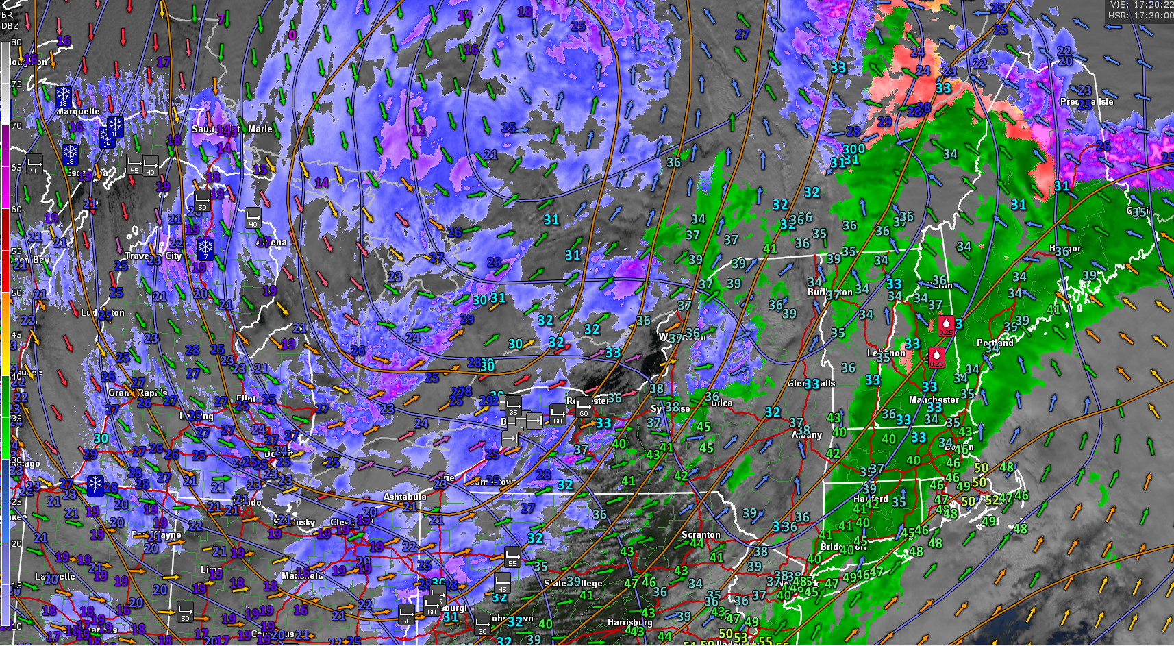
TONIGHT: Mainly cloudy.A round of evening snow showers tapers to occasional flurries. Up to an inch higher terrain with slick travel. An eventual low upper single digits to around 10 above. Blustery west to southwest winds 10 to 20 mph lowering wind chills.
TOMORROW: Mostly cloudy. Mountain snow showers and valley flurries mainly northern areas with minor accumulation. Blustery to windy at times. Remaining rather frigid with slightly falling temperatures 5 to 10 above. West winds 10 to 25 mph with higher gusts lowering wind chills.

TUESDAY NIGHT: Becoming partly cloudy. Scattered mountain snow showers or flurries with minor accumulation northern areas. Continued a bit blustery at times. A low ranging 5 below to 10 above. West winds 10 mph lowered wind chills.
WEDNESDAY: Maybe break or two of sun. Chance for a stray flurry north and far south. Blustery at times. A high upper teens around 20. Southwest winds 10 to 15 mph.
Looking further ahead
WEDNESDAY NIGHT NEW YEARS EVE: Mostly cloudy. Rising chance for snow showers with a dusting to an inch. A low in the single digits.
THURSDAY NEW YEARS DAY: Partly to mostly sunny. A high in the mid-teens.
FRIDAY: Clouds with intervals of sunshine. Isolated northern flurries. Continued frigid. Lows 5 to 15 below. Highs in the teens.
Full Wolf Moon 5:03 AM…
SATURDAY: Partly to mostly cloudy. A stray flurry or two. Lows zero to ten above. Highs low to mid-teens.

Average low: mid-single digits to low teens. Average high 25 to 30
Admin: No forecast Tuesday, December 30th
Approximate peak of winter or halfway point – January 22nd
RH/12-29/forecast][end] Fox Trot Delta Tango
