
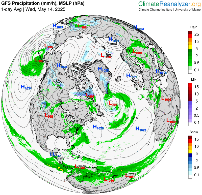
Roger Hill’s Radio Vermont Forecast 3:00 PM WEDNESDAY 5-14-25
TONIGHT: Partly to mostly cloudy. Maybe an isolated sprinkle. A low mid to upper 50s. Light southeast winds.
TOMORROW: More clouds and sun. A bit humid. Isolated afternoon showers. Maybe a rumble of thunder. A high near 75. South to southeast winds 10 mph.

THURSDAY NIGHT: Partly cloudy early, then more cloudiness. A low mid to upper 50s. Light south winds.
FRIDAY: Mixed sun and clouds. A little muggy. Chance for late afternoon showers and a few thunderstorms. A high mid to upper 70s. South breeze 10 mph, stronger near Lake Champlain.

Looking further ahead
FRIDAY NIGHT: Partly to mostly cloudy. Scattered evening showers and thunderstorms especially northern western Vermont. Lows upper 50s around 60.
SATURDAY: Partial morning sun the clouding up. Scattered late day & evening showers and thunderstorms, some locally heavy. A high in the low 70s.
SUNDAY: Intervals of sun but lots of afternoon clouds. Chance for a few showers. Cooler & not as humid. A low 50 to 55. Highs 60 to 65.
MONDAY: Gray and chilly. Chance for light showers northern/central areas. Lows 35 to 40. High only around 50.
Average low: range upper 30s to mid-40s. Average highs: mid to upper 60s.
Start of Meteorological Summer June 6th. (Warmest 90 days climatology)
Summer Solstice June 20th 10:41 PM EDT
Admin: Note no weather issued Thursday, back Friday 3:00 PM.

RH/5-14[forecast][end]
