

Roger Hill’s Radio Vermont Forecast 3:00 PM Friday 2-28-25
TONIGHT: Overcast. Periods of light accumulating snow by midnight. Around an inch or so. An evening low upper single digits to lower teens. Winds becoming south to southeasterly 10 to 15 mph, stronger near Lake Champlain.
TOMORROW: Clouds maybe a break or two of sun. Widely scattered snow and rain showers or sprinkles. A late day high pushing 40. Increasing west to southwest winds 10 to 20 mph in the afternoon.
SATURDAY NIGHT: Lots of clouds. Scattered lingering mountain flurries with a dusting…giving way to partial clearing overnight. A low zero to 10 below. Northwest winds 10 mph with lowered wind chills.
SUNDAY: Morning clouds then increasingly sunny. A high just 5 to 10 degrees above. Northwest winds 10 to 20 mph lowering wind chills.
Looking further ahead
SUNDAY NIGHT: Mostly clear. Frigid.A low 5 to 15 below.
MONDAY: Sunshine giving way to late afternoon clouds. Highs in the upper teens.

TUESDAY TOWN MEETING: Mainly gray. Chance for wet snow showers mixed with rain valleys with a light coating high elevations. A low around zero. A high in the mid-30s.

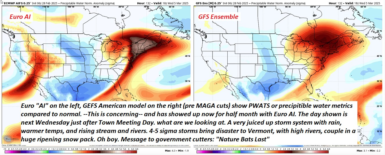
WEDNESDAY: Gray. Rain…moderate at times with milder temperatures and snow melt. Rising stream and river levels could produce the potential for flooding of low lying areas, and coupled with possible ice jams. A low 35 to 40. A high near 45.
Average low ranging mid-single digits to mid-teens. Average high ranging thru the 30s.
RH/2-28[forecast][end]
