

TODAY: Lots of clouds in northern areas with a stray morning flurry drying up. Periods of partial afternoon sunshine. A high around 25. Northwest winds 10 mph.
TONIGHT: Partly cloudy this evening, then clouding up overnight. A low in the mid-teens. Little wind.
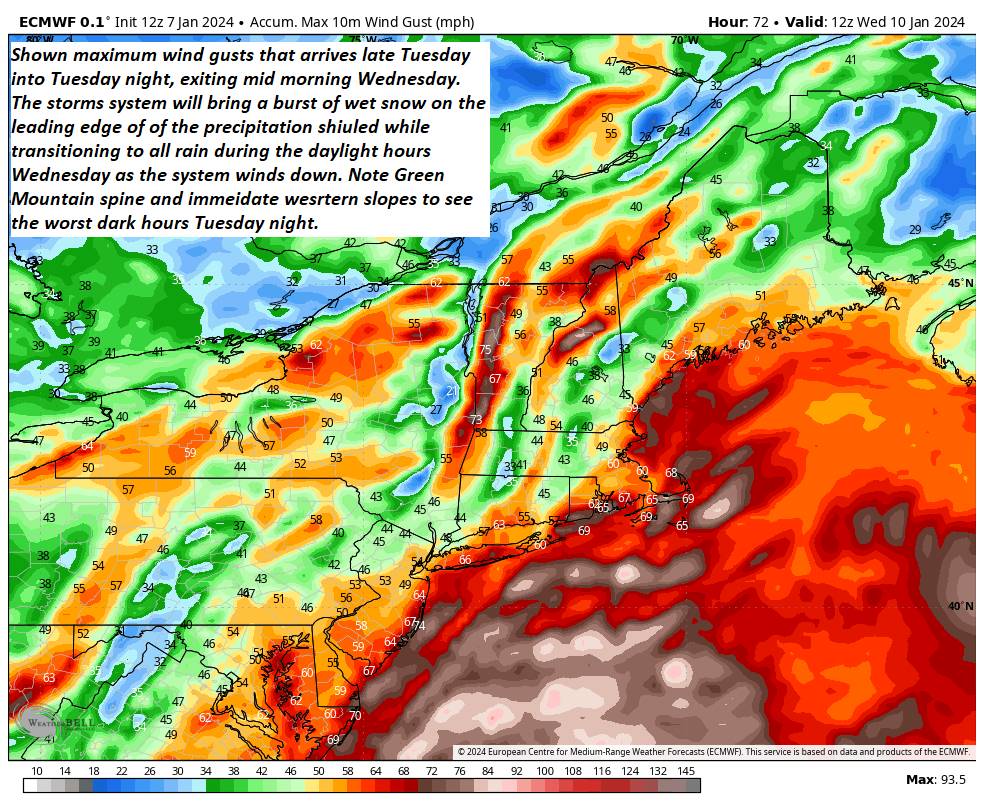
High Wind Watch from Tuesday afternoon thru Wednesday afternoon…
TUESDAY: Gray. A rising chance for light accumulating snow developing toward dark. A high in the mid to upper 20s. Southeast winds ramping up 10 to 25 mph late.
Looking further ahead
TUESDAY NIGHT: Overcast & windy. Wet snow likely, moderate to heavy at times …with a few to several inches accumulation…transitions to a wintry mix…and eventually rain by daybreak. Temperatures rising into the mid and upper 30s by daybreak. Southeasterly winds 15 to 35 mph with gusts over 45 mph.
WEDNESDAY: Lots of clouds with periods of morning rain likely. Scattered rain showers and milder in the afternoon with a few intervals of sunshine. A morning high around 45.
THURSDAY: Mainly cloudy. A few mountain flurries. A low around 30. A high in the low to mid 30s. c
FRIDAY: Pick of the week.Partly to mostly sunny. A low around 25. A high near 32.
SATURDAY: Morning clouds. Chance for accumulating wet snow with a few inches possible transitioning to periods of rain or showers with intervals of sunshine. A low in the mid-20s. A high around 40.

Average lows single digits. Average highs mid-20s to 30
RH/1-8forecast][end]
