Weathering Heights, Roger Hill's weather forecasting service

Weathering Heights, Roger Hill's weather forecasting service

Menu

Skip to content
  • Home
  • About Roger Hill
  • Quick Weather Updates

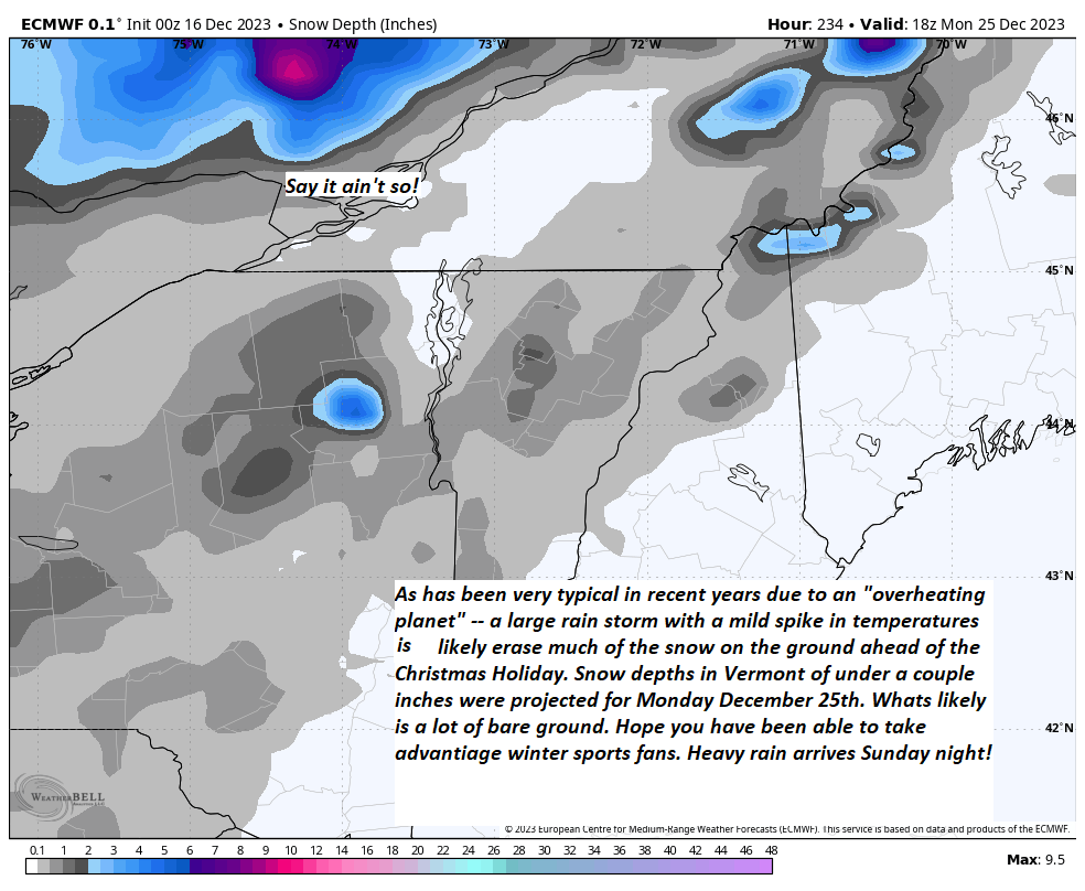
Pre-Christmas rainfall on track with potential for river rises and flooding — Sunday night into Monday. Additionally, gusty winds may be in play on mountain summits and western slopes of the Greens.

Posted on December 16, 2023 by Weathering Heights

Share this:

  • Share on X (Opens in new window) X
  • Share on Facebook (Opens in new window) Facebook
Like Loading...

Related

This entry was posted in Quick Weather Updates. Bookmark the permalink.

Post navigation

← Updated Friday evening Forecast — December 1st, 2023
Deep low-pressure rides in with moisture levels loaded for bear to produce heavy rains and high winds. Additionally, the system originating in the Gulf of Mexico brings a mild shot. The combined effects all together is a recipe for some major flooding. “Keep informed on this significant storm system” especially in low lying areas. →
Top 100 Weather Blog

Weathering Heights is a Feedspot Top 100 Weather Blog

Climate Reanalyzer

Tools to Visualize Climate and Weather Forecast Models

Daily Climate Maps updated 10:30 AM (courtesy of NWS Burlington VT)

Daily Climate Maps courtesy NWS-Burlington

forecast condition a few hours from now

forecast condition a few hours from now...

Precipitation amount forecast today

Precipitation amount forecast today

Recent earthquakes

Recent earthquakes

30 day observation precipitation graph Burlington VT

30 day observation precipitation graph Burlington VT

Link to Burlington 90 precipitation plot

90 day observation precipitation graph Burlington VT

River Check

Northeast River Forecast Center

Sun - current solar activity

Sun - Current Solar Activity

My Tweets

Climate Notes

Web cam from Weathering Heights in Worcester, Vermont, looking south toward Montpelier

Weathering Heights Web Cam, looking south toward Montpelier and uptown Berlin (refresh browser to update)

Plymouth State Radar

Plymouth State Radar

Current northeast U.S. infrared and visual satellite

Road Conditions

VTrans Road Conditions

Flight Delays

Flight delays

link to www.co2.earth

CO2.earth

Current Arctic Ice

link to 3 to 7 day upcoming weather hazards

3 to 7 day upcoming Weather Hazards

Follow Weathering Heights, Roger Hill's weather forecasting service on WordPress.com
Plymouth State Radar

Plymouth State Radar

Blog at WordPress.com.
  • Reblog
  • Subscribe Subscribed
    • Weathering Heights, Roger Hill's weather forecasting service
    • Join 132 other subscribers
    • Already have a WordPress.com account? Log in now.
    • Weathering Heights, Roger Hill's weather forecasting service
    • Subscribe Subscribed
    • Sign up
    • Log in
    • Copy shortlink
    • Report this content
    • View post in Reader
    • Manage subscriptions
    • Collapse this bar
 

Loading Comments...
 

    %d