

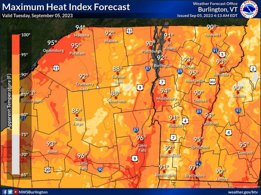
Heat Advisory 1 PM thru 7 PM this evening…
TODAY: Fog burns off to hazy sunshine. Warm and humid. A high mid to upper 80s with heat indices upper 80s to low 90s. Light north to northwest winds.
TONIGHT: Mostly clear skies with scattered clouds overnight. Patchy valley fog. A low around 65. Little wind.
WEDNESDAY: Partly to mostly sunny. A high 85 to 90 with heat indices pushing into the upper 80s to mid-90s. Light northwest winds.

Looking further ahead
WEDNESDAY NIGHT: Mostly clear. Patchy valley fog. A low upper 60s.
THURSDAY: Partly to mostly sunny after morning fog. A late day isolated afternoon shower or thunderstorm, western areas. Warm and sultry. A high mid to upper 80s with heat indices pushing into the upper 80s to mid-90s.

FRIDAY: Morning fog burns off to sunshine with a few afternoon clouds. Widely scattered afternoon showers and thunderstorms. Continued sticky. A low in the upper 60s. A high in the mid-80s. Heat indices pushing into the upper 80s to low 90s
SATURDAY: Mixed sun and clouds. Widely scattered afternoon showers and isolated thunderstorms. A low 60 to 65. A high in the low-80s.
SUNDAY: Mostly cloudy. Chance for showers and afternoon thunderstorms. A low around 65. A high low 70s.
MONDAY: Partly to mostly cloudy. Scattered showers and thunderstorms. A low in the low 60s. A high upper 60s to around 70.
Average lows mid-40s to mid-50s. Average highs in the low to mid 70s.
RH/9-5-23 forecast][end]
