
TONIGHT: Mostly clear. Any early evening showers dry up. A low in the upper 50s and a touch less humid. Light south to southwest winds.
TOMORROW: Morning valley fog burns off to Lots of sunshine. An isolated shower possible. A high in the low 80s Southwest breeze 10 mph.
WEDNESDAY NIGHT: Mostly fair with thickening high clouds. More muggy. Isolated valley fog. A low 65 to 70. South winds 10 mph stronger near Lake Champlain.
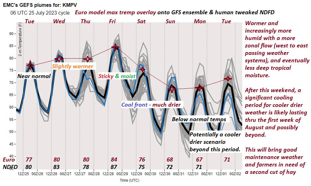
THURSDAY: Considerable cloudiness. Chance for numerous showers moderate to briefly heavy…with embedded thunderstorms. A high mid to upper 70s. Southwest breeze kicks up 10 to 20 mph.
Looking further ahead
THURSDAY NIGHT: Isolated early evening showers and strong thunderstorms exiting. Muggy and more uncomfortable. A low upper 60s.
FRIDAY: Morning fog, then partly to mostly sunny. A rising chance for late day showers and heavy thunderstorms northern border areas. Sticky. A high 80 to 85 but feeling much hotter with high dew points.
SATURDAY: Mostly cloudy. Chance for rain or showers with embedded heavy thunderstorms. A low 65 to 70. A high mid to upper 70s.
SUNDAY: Sunny with a few high clouds, much less humid and cooler. A low in the low 50s. A high in the low 70s.
Average lows 55 to 60. Average high upper 70s to low 80s.
RH/7-24 forecast][end]
