

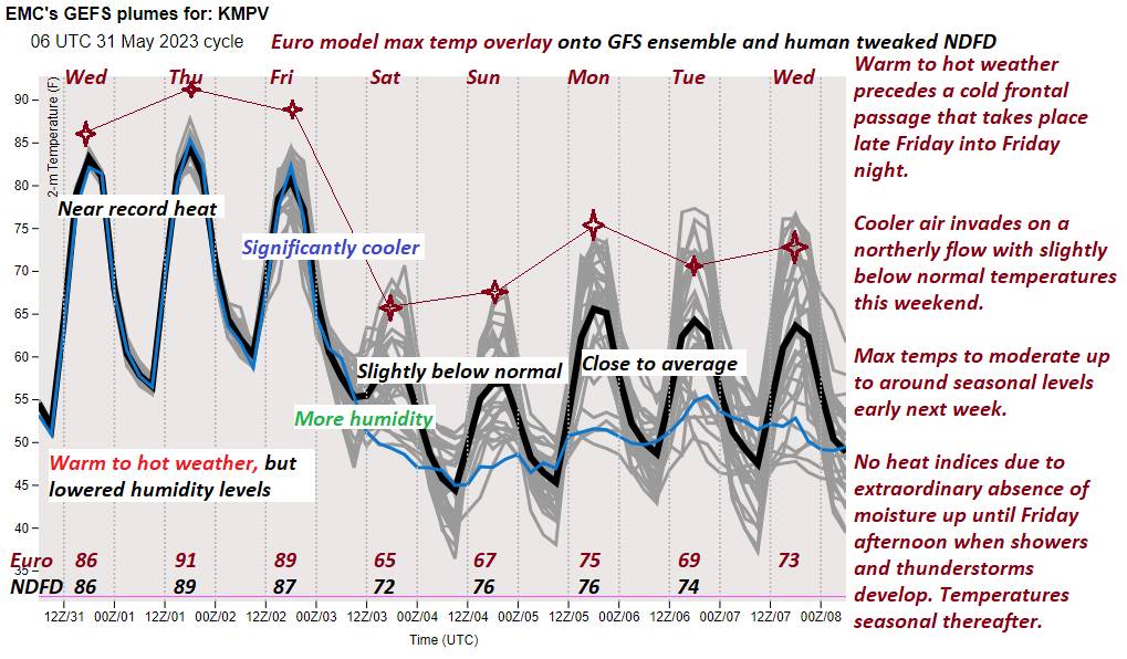
TODAY: Sunny, a few afternoon clouds. A record high in the lower 90s with low to moderate humidity levels. Light northwest winds.
TONIGHT: Clear & partially moonlit. Not as cool. A low near 60. Little wind.
FRIDAY: Morning sun, then partly sunny and more humid. Showers and thunderstorms likely by mid- afternoon…one or two strong and locally heavy. A near record high mid to upper 80s. North to northwest winds 10 mph.
Looking further ahead
FRIDAY NIGHT: Considerable cloudiness. Isolated evening showers and thunderstorms, flare up toward midnight. A low in the low to mid 50s.
Full strawberry Moon 11:42 PM Saturday night…
SATURDAY: Lots of clouds with a few showers central and southern areas. Intervals of afternoon sunshine much cooler with below normal temperatures. Chance for showers especially eastern and southern areas. A high 60 to 65.
SUNDAY: Morning sun, then more clouds eastern areas. A low in the mid-40s. A high in the upper 60s.
MONDAY: Mostly cloudy. A threat for a shower. A low in the mid to upper 40s. A high upper 60s.
Approximate start of meteorological summer…
TUESDAY: Gray skies. Scattered showers. A low in the mid-40s. A high 60 to 65.
Average lows ranging 45 to 50. Average highs 70 to 75
Start of Meteorological summer this next Tuesday June 6th Summer Solstice hits June 21st

RH/6-1 forecast][end]
