
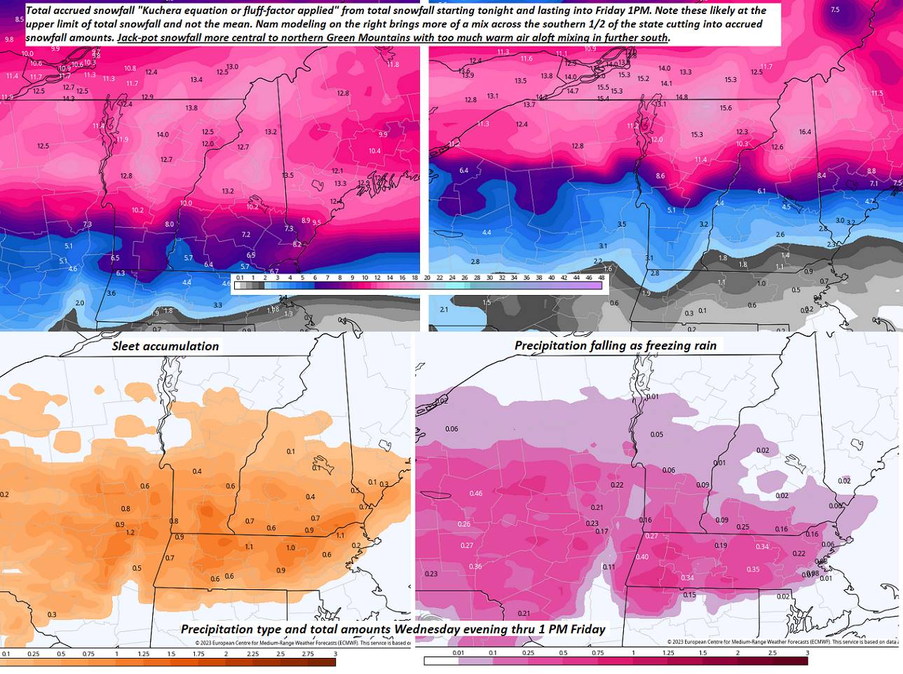
Winter Storm Warning this evening lasting into Thursday afternoon…
TONIGHT: Cloudy. Periods of accumulating snow developing later this evening, moderate to briefly heavy at times overnight. About 4 to locally 9” accumulation. A wintry mix southern areas overnight with lesser amounts.A low mid-teens to low-20s. Light northeast wind.
TOMORROW: Gray.Periods of snow…winding down mid-morning. Isolated to widely scattered mixed precipitation lingering.Slick travel with light accumulations up to couple tenths of an inch of glazing south. Total accumulation 6 to 12”. A high near 25. Light east winds.
THURSDAY NIGHT: Cloudy. A light wintry mix changing back to scattered snow showers/flurries. Accumulation dusting to 2” with the most northern tier.Temperatures holding in the mid-20s to low 30s. Light southwest winds.
FRIDAY: Scattered mountain flurries exiting early afternoon. Otherwise mostly cloudy.Blustery and sharply colder. Temperatures falling thru the mid and low teens with lowered wind chills. Northwest winds 10 to 25 mph and gusty
Looking further ahead
FRIDAY NIGHT: Evening clouds then mostly clear and frigid. A low ranging from 5 to 20 below zero.
SATURDAY: Filtered sunshine gives way to thickening clouds with a rising chance for flurries little accumulation.Frigid.A high 10 to 15.
SUNDAY: Mainly cloudy. Chance for fluffy snow showers & flurries. 1 to locally 4” accumulation possible. Frigid. A low 10 below to 5 above. A high 25 to 30.
MONDAY: Filtered sunshine thru high cloudiness. A low zero to 10 above. A high around 30.
TUESDAY: Overcast. Chance for snow or mixed precipitation…possibly significant amounts. A low upper teens to mid-20s. A high upper 20s to mid-30s.
Average lows upper single digits to mid-teens. Average highs in the low to mid-30s.
Climatological winter ends March 9th… Vernal equinox March 20th as we start spring
RH/2-22 forecast][end]
