Updated Thursday Evening Forecast — March 24th, 2022

TONIGHT: Cloudy. An isolated shower or sprinkle this evening. Rain showers, moderate at times later overnight. A slight risk for freezing rain with slick travel toward New Hampshire. A low 32 to 35. Light winds.

TOMORROW: Clouds with a few breaks of sun. Rain showers in the morning dry up in the afternoon. A little milder, with a high around 50. Westerly breeze 10 mph.

FRIDAY NIGHT: Mostly cloudy. Widely scattered wet snow showers or sprinkles. A low 30 to 35. Light southwest winds.

SATURDAY: Clouds with a few intervals of sunshine. Widely scattered rain and snow showers. A high mid to upper 40s. Southwest winds 10 mph.

Looking further ahead…

SATURDAY NIGHT: Partly to mostly cloudy. A few sprinkles or wet snow flurries overnight. A low near 30.

SUNDAY: Mostly cloudy and blustery and turning colder. Scattered wet snow or rain showers. Minor accumulation grassy surfaces late. A high 40 to 45, then colder in the afternoon.

MONDAY: Mostly cloudy, blustery & colder…feels like winter. Scattered mountain snow showers and valley flurries. A low down to around 15. A high just in the mid-20s.

TUESDAY: Morning clouds then mostly sunny. A low around 15. A high 30 to 35.

WEDNESDAY: Sunshine, mixing with more clouds. A low 15 to 20. A high in the 40 to 45.

Average lows ranging upper-teens thru mid-20s. Average highs low to mid 40s

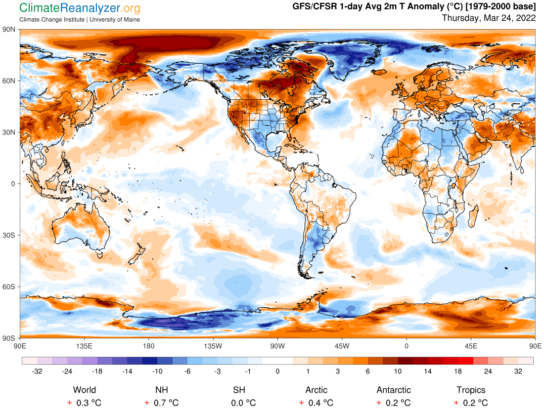
RH/3-24 forecast][end]

Updated Thursday Morning Forecast — March 24th, 2022

Winter Weather Advisory expires early this afternoon…

TODAY: Intermittent light rain with spotty freezing rain and light glazing east of the Greens in the morning…transitioning to scattered rain showers & a few wet snow flakes mountains later this morning. A late day high near 40. Blustery. Southeast winds 10 to 15 mph stronger western slopes of the Greens early.

TONIGHT: Occasional rain showers…moderate at times… mixed with pockets of freezing rain far eastern Vermont. A low 32 to 35. Light northeast winds.

FRIDAY: Mostly cloudy. Rain showers mixed with wet snow high terrain early, then scattered rain showers in the afternoon. A little milder, with a high mid-40s to low 50s. West breeze 10 mph.

Looking further ahead…

FRIDAY NIGHT: Mostly cloudy. Scattered rain & wet snow showers little if any accumulation. A low around 35.

SATURDAY: Partly to mostly cloudy. Widely scattered rain and snow showers. A high in the mid-40s.

SUNDAY: Mostly cloudy and continued unsettled and colder. Scattered wet snow showers minor accumulation. A low around 32. An early high upper 30s to 40, then colder in the afternoon.

MONDAY: Mostly cloudy & a brief return to winter. Chance for snow showers or snow squalls with a dusting to 2 inches. A low in the mid to upper teens. A high 25 to 30.

Average lows ranging upper-teens thru mid-20s. Average highs low to mid 40s

RH/3-23 forecast][end]

Updated Wednesday Evening Forecast — March 23rd, 2023

Winter Weather Advisory 2 AM Thursday morning thru 2 PM Thursday afternoon…

TONIGHT: Overcast. A “wintry mix” develops around or after midnight transitioning to freezing rain…with slick travel outside the slightly warmer Champlain Valley. A low about 32 degrees. Southeast winds picking up 10 to 20 mph, stronger western slopes overnight.

TOMORROW: Freezing rain with glazing along and east o0f the Greens in the morning…transitioning to scattered rain showers mixed with wet snow flakes. A late day high upper 30s to about 40. Blustery. Southeast winds 10 to 15 mph stronger western slopes of the Greens early.

THURSDAY NIGHT: Occasional rain showers…moderate at times… mixed with pockets of freezing rain eastern Vermont. A low 32 to 35. Light northeast winds.

FRIDAY: Mostly cloudy. Rain showers mixed with wet snow high terrain early, then scattered rain showers in the afternoon. A little milder, with a high in the lower 50s. West breeze 10 mph.

Looking further ahead…

FRIDAY NIGHT: Mostly cloudy. Scattered rain & wet snow showers little if any accumulation. A low 30 to 35.

SATURDAY: Partly to mostly cloudy. Widely scattered rain and snow showers. A high 40 to 45.

SUNDAY: Mostly cloudy and continued unsettled and colder. Scattered wet snow showers minor accumulation. A low around 30. An early high in the mid-30s then colder in the afternoon.

MONDAY: Mostly cloudy & a brief return to winter. Chance for snow showers or snow squalls with a dusting to 2 inches. A low in the mid-teens to around 20. A high 25 to 30.

Average lows ranging upper-teens thru mid-20s. Average highs low to mid 40s

RH/3-23 forecast][end]

Updated Wednesday Morning Forecast — March 23rd, 2022

TODAY: Periods of morning sunshine becoming filtered through high cloudiness. A high near 45 with a sap run. Light east to northeast winds.

Winter Weather Advisory 2 AM Thursday morning thru 2 PM Thursday afternoon…

TONIGHT: Overcast. A “wintry mix” with mostly freezing rain…developing after midnight will produce slick travel east of the Green Mountains. A low right at 32 degrees. Southeast winds picking up at overnight at 10 to 20 mph stronger western slopes of the Greens.

THURSDAY: Freezing rain with glazing in the morning…transitioning to rain showers…but mixed with a few wet snow flakes in the afternoon. A late day high in the upper 30s. Blustery. Southeast winds 10 to 15 mph stronger western slopes of the Greens.

Looking further ahead…

THURSDAY NIGHT: Showers of rain, mixed with pockets of freezing rain east of the Green Mountains. A low in the mid-30s.

FRIDAY: Mostly cloudy. Rain showers mixed with wet snow and pockets of freezing rain early. Milder in the afternoon with a high in the low 50s.

SATURDAY: Partly to mostly cloudy. Widely scattered rain and snow showers. A low 30 to 35. A high 40 to 45.

SUNDAY: Mostly cloudy and continued unsettled and colder. Scattered wet snow showers minor accumulation. A low around 30. An early high in the mid-30s then colder in the afternoon.

MONDAY: Mostly cloudy & a brief return to winter. Chance for snow showers or snow squalls with a dusting to 2 inches. A low in the mid-teens to around 20. A high 25 to 30.

Average lows ranging upper-teens thru mid-20s. Average highs low to mid 40s

RH/3-23 forecast][end]

Updated Tuesday Evening Weather — March 22nd, 2022

TONIGHT: Mostly clear with some high clouds. A low in the low to middle 20s. Light northwest winds.

TOMORROW: High cloudiness with hints of sunshine. A high near 45. Light east to northeast winds.

WEDNESDAY NIGHT: Overcast. A wintry mix developing late evening on…producing slick travel east of the Green Mountains. A low in the low 30s. Southeast winds picking up at overnight at 10 to 20 mph stronger western slopes of the Greens.

THURSDAY: A wintry mix…transitioning to rain showers in the afternoon…mixed with wet snow in the mountains. A late day high 35 to 40. Blustery. Southeast winds 10 to 15 mph stronger western slopes of the Greens.

Looking further ahead…

THURSDAY NIGHT: Showers of mixed precipitation with a light coating and some slick travel elevated terrain. A low around 32.

FRIDAY: Mostly cloudy. Good chance for rain or wet snow showers with pocket of freezing rain. A high mid to upper 40s.

SATURDAY: Partly to mostly cloudy. Scattered snow showers mixed with rain valleys. A low 32 to 35. A high in the low 40s.

SUNDAY: Mostly cloudy and continued unsettled. Scattered rain and snow showers with minor accumulation. A low 30 to 35. A high around 40.

Average lows ranging upper-teens thru mid-20s. Average highs low to mid 40s

RH/3-22 forecast][end]

Updated Tuesday Morning forecast — March 22nd,2022

TODAY: Lots of sunshine, but blustery and colder. A high in the upper 30s. Northwest winds 10 to 25 mph.

TONIGHT: Mostly fair with some high clouds. A low in the low to middle 20s. Light northwest winds.

WEDNESDAY: High cloudiness with hints of sunshine. A high near 45. Light east to northeast winds.

Looking further ahead…

WEDNESDAY NIGHT: Overcast. A wintry mix or periods of freezing rain becoming likely with hazardous travel east of the Green Mountains. Gusty southeasterly winds western slopes of the Greens overnight. A low in the low 30s.

THURSDAY: A wintry mix of wet snow, sleet and pockets of freezing rain early…transitioning to rain showers…mixed with wet snow elevated terrain in the afternoon. A late day high 35 to 40. Gusty southeasterly winds western slopes of the Greens in the morning.

FRIDAY: Mostly cloudy. Good chance for rain or wet snow showers with pocket of freezing rain. A low near 32. A high near 40.

SATURDAY: Partly to mostly cloudy. Scattered snow showers mixed with rain valleys. A low 32 to 35. A high 40 to 45.

SUNDAY: Mostly cloudy and continued unsettled. Scattered rain and snow showers with minor accumulation. A low 30 to 35. A high in the lower 40s.

Average lows ranging upper-teens thru mid-20s. Average highs low to mid 40s

RH/3-21 forecast][end]

Updated Monday Evening Forecast — March 21st, 2022

TONIGHT: Partly cloudy northern areas. A low in the low to mid 20s. Northwest winds 10 mph.

TOMORROW: Lots of sunshine, but blustery and colder. A high in the upper 30s. Northwest winds 10 to 25 mph.

TUESDAY NIGHT: Mostly fair with some high clouds. A low in the low to mid 20s. Light northwest winds.

WEDNESDAY: High cloudiness with hints of sunshine. A high near 45. Light east to northeast winds.

Looking further ahead…

WEDNESDAY NIGHT: Overcast. A rising chance for wet snow transitioning sleet, freezing rain and rain, making for slick travel. Gusty southeasterly winds western slopes of the Greens. A low 30 to 35.

THURSDAY: A wintry mix of wet snow, sleet and pockets of freezing rain in the morning transitioning to wet snow or rain showers in the afternoon. A late day high mid-30s to low 40s.

FRIDAY: Mostly cloudy. Scattered rain showers mixed with wet snow, and pocket of freezing rain. A low around 35. A high mid to upper 40s.

SATURDAY: Partly to mostly cloudy. Scattered snow showers mixed with rain valleys. A low 32 to 35. A high 40 to 45.

Average lows ranging upper-teens thru mid-20s. Average highs low to mid 40s

RH/3-21 forecast][end]

Updated Monday morning forecast — March 21st, 2022

TODAY: Partly cloudy northern areas with periods of sunshine south. A few brief snow or rain showers mainly late morning into the early afternoon. Rather blustery. A high 40 to 45. Northwesterly winds 10 to 25 mph and gusty this afternoon.

TONIGHT: Partly cloudy northern areas. A low in the low to mid 20s. Northwest winds 10 mph.

TUESDAY: Mostly sunny. Blustery & cooler. A high 35 to 40. Northwest winds 10 to 25 mph.

Looking further ahead…

TUESDAY NIGHT: Mostly fair with some high clouds. A low in the low to mid 20s

WEDNESDAY: Considerable high cloudiness with hints of sunshine. Gusty southeasterly winds developing Wednesday night. A high near 45.

THURSDAY: A wintry mix of wet snow, sleet and pockets of freezing rain in the morning transitioning to wet snow or rain showers in the afternoon. A low 30 to 35. A high upper 30s to near 40.

FRIDAY: Mostly cloudy. Scattered rain showers mixed with wet snow flakes. A low in the mid-30s. A high in the upper 40s.

Average lows ranging upper-teens thru mid-20s. Average highs low to mid 40s

RH/3-21 forecast][end]

Updated Friday Evening Forecast — March 18th, 2022

TONIGHT: Considerable cloudiness. Light rain showers developing overnight. Maybe a slick spot toward Connecticut River Valley. A low 35 to 40. Light east winds.

TOMORROW: Gray & damp. Rain showers…moderate at times. A high near 45. Southeast breeze 10 to 15 mph.

SATURDAY NIGHT: Variable cloudiness. Occasional rain showers…moderate at times, Maybe a rumble of thunder southern areas, areas of fog. A low in the low 40s. Light winds becoming southwesterly 10 mph overnight.

Spring Equinox 11:33 AM

SUNDAY: Scattered rain showers. A few breaks of sun. A high in the upper 40s to around 50. Southwest winds 10 mph.

Looking further ahead…

SUNDAY NIGHT: Mostly cloudy. A low around 32 to 35.

MONDAY: Morning sunshine then more afternoon clouds & blustery. Maybe a few flurries or sprinkles far north. A high near 45.

TUESDAY: Scattered flurries in the morning, otherwise more clouds than sun. Blustery & colder. A low in the low to mid 20s. A high mid to upper 30s.

WEDNESDAY: Partly to mostly sunny. A low in the low to mid 20s. A high 40 to 45.

Average lows ranging mid-teens thru low 20s. Average highs upper 30s to low 40s.

RH/3-18 forecast][end]

Updated Friday Morning Forecast — March 18th, 2022

TODAY: Areas of dense fog early burning off to partly to mostly sunny skies. Continued very mild…with snow melt and very soft muddy back roads. A high around 60. Northwest winds 10 mph.

TONIGHT: Thickening clouds. Rain showers becoming likely after midnight. A risk of isolated slick spots far eastern Vermont valleys. A low mid-30s to around 40…coolest Northeast Kingdom. Light east winds.

SATURDAY: Overcast & rather wet. Rain showers likely…moderate at times. A risk for a thunderstorm southern areas late. Areas of fog. A high 40 to 45. Southeast breeze 10 to 20 mph.

Looking further ahead…

SATURDAY NIGHT: Cloudy. Occasional rain showers…moderate at times, a risk for a rumble of thunder southern areas, areas of fog. A low around 40.

Spring Equinox 11:33 AM

SUNDAY: Scattered rain showers…mixed with wet snow flakes higher terrain. Maybe a few breaks of afternoon sun. A high 45 to 50.

MONDAY: Morning sunshine then more afternoon clouds & blustery. Scattered rain or wet snow showers. A low around 30. A high 40 to 45.

TUESDAY: More clouds than sun. Blustery & colder. Scattered flurries in the morning. A low around 25. A high in the lower 30s.

Average lows ranging mid-teens thru low 20s. Average highs upper 30s to low 40s.

RH/3-18 forecast][end]