
TODAY: Gray. Occasional wet snow…mixed with rain valley floors. Minor accumulation higher terrain. A high 35 to 40. Light east to southeast winds.
High Wind Warning western slopes of the Central Green Mountains, Wind Advisories Northern Tier higher terrain…
TONIGHT: Cloudy. Periods of rain with wet snow accumulation above 1500 ft. Blustery to windy especially western slopes of the Green Mountains overnight. A low 32 to 35 degrees. East to southeast winds 10 to 20 mph, stronger gusts western slopes of Greens Mountains and higher terrain.
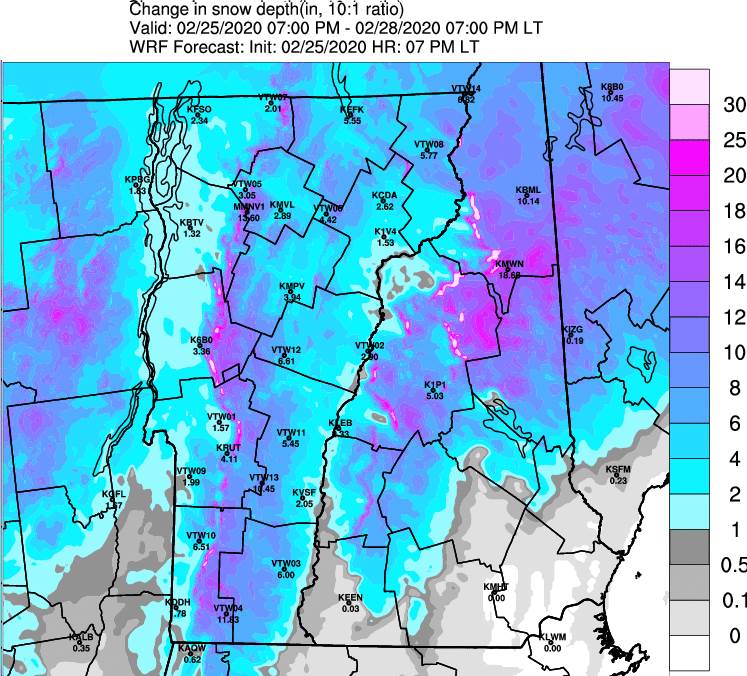
THURSDAY: Cloudy. Periods of rain lower valleys with periods of wet snow accumulation intermediate and higher terrain. Several inches Green Mountain Ski Resorts upper slopes/summits limited to an inch valley floors. Blustery to windy in the morning. A high mid to upper 30s. Southeast winds 10 to 25 mph gusting 40 to 65 mph western slopes central Greens…shifting southwesterly in the afternoon.
Looking further ahead…
THURSDAY NIGHT: Considerable cloudiness. Chance for a few flurries. A low in the mid to upper teens.
FRIDAY: Lots of clouds, but some intervals of sun. A few stray flurries. A high 25 to 30.
SATURDAY: A few stray flurries. Otherwise, more clouds than sun. A low around 10 above. A high around 25.
SUNDAY: Partly to mostly sunny. A low zero to 10 below. A high 20 to 25.
Average lows in the teens, average highs in the 30s….
RH/2-25[end]
