
TONIGHT: Fair with high cloudiness. A low 60 to 65. Light southeast winds.
TOMORROW: More clouds than sun. Muggy. Widely scattered showers developing southern areas in the morning. Scattered showers and thunderstorms in the afternoon. A high in the upper 70s to around 80. South breeze 10 to 15 mph.
THURSDAY NIGHT: Mostly cloudy & muggy. Showers likely with a few thunderstorms. A low in the mid 60s. South winds 10 mph.
FRIDAY: Morning clouds with a good chance for lingering showers…giving way to intervals of afternoon sunshine. A high near 80. Wind becoming west to northwest 10 mph in the afternoon.
Looking further ahead…
FRIDAY NIGHT: Just scattered clouds and partially moonlit skies. A low 55 to 60.
SATURDAY: Partly sunny. Chance for a late day shower or thunderstorm northern areas. A high 80 to 85.
SUNDAY: More clouds than sun. Widely scattered showers and a risk for a thunderstorm exiting late. A low around 60. A high mid to upper 70s.
MONDAY: Partly to mostly sunny. Pleasant and comfortable. A low 50 to 55. A high upper 70s to near 80.
TUESDAY: Partly to mostly sunny. A low 55 to 60. A high in the low to mid 80s.
WEDNESDAY: Mixed sun and clouds. Widely scattered showers and thunderstorms. A low 60 to 65. A high in the mid 80s.
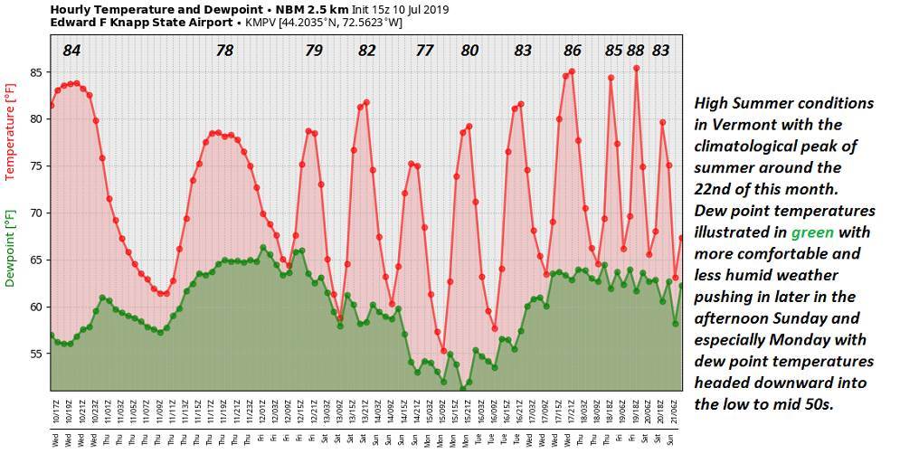
Average lows mid 50s to low 60s. Average highs upper 70s to low 80s.
Warmest 90 days of meteorological summer peaks July 22nd…
RH/7-10-19[end]
