
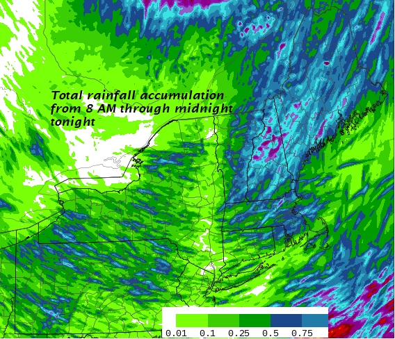
TODAY: Periods of rain through late morning…tapering off to widely scattered afternoon showers with a few intervals of sun. A high in the mid 70s. Southwest breeze becoming northwesterly 10 to 15 mph.
TONIGHT: A few mountain sprinkles exiting early. Otherwise clearing and partially moonlit. Dense valley fog developing. A low around 55. West to northwest winds 10 mph.
THURSDAY: Partly to mostly sunny. A high around 70. Northwest breeze 10 to 15 mph.
Looking further ahead…
THURSDAY NIGHT: Clear and moonlit skies. Patchy valley fog. A low 50 to 55.
FRIDAY: Morning fog then tons of sunshine and warmer. A high in the low 80s.
SATURDAY: Mixed clouds and sun. A low 55 to 60. A high in the low 80s.
Full Sturgeon Moon Sunday 7:56 AM
SUNDAY: More clouds than sun. Slight chance for a shower or thunderstorm. A low near 60. A high in the low 80s.
MONDAY: Partly sunny & sticky. Chance for a shower or thunderstorm. A low 60 to 65. A high in the low 80s.
TUESDAY: Mixed sun and clouds. Slight chance for an afternoon shower or thunderstorm. A low in the 60s. A high in the low to mid 80s.
Average lows in the low to mid 50s. Normal highs in the mid to upper 70s.
RH/8-22-18[end]
| Virus-free. www.avast.com |
