
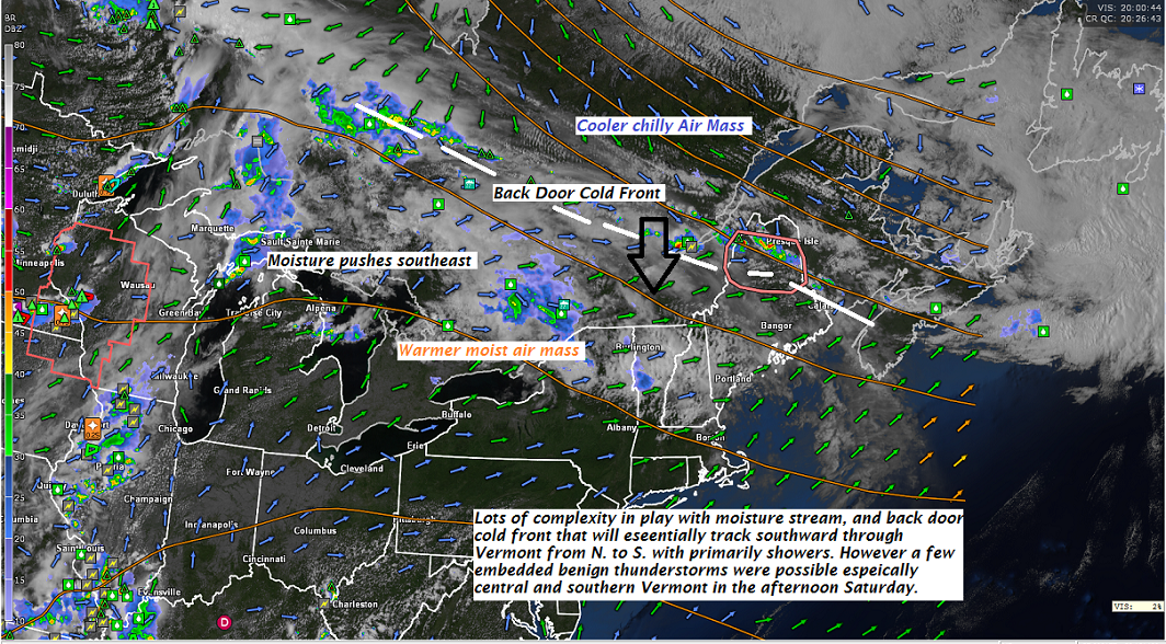
TONIGHT: Showers likely overnight northern areas. Maybe a rumble or two of thunder. Otherwise cloudy and kind of humid. A low upper 50s to mid 60s. Light southwest winds.
TOMORROW: Sun mixed with cloudy periods. Showers northern areas in the morning, tracking southward into the afternoon with a chance for a few thunderstorms. A high in the mid 70s. North to northwest breeze 10 mph.
SATURDAY NIGHT: Chance for shower or storm south of the Barre-Montpelier area. Otherwise mostly cloudy. Patchy valley fog. A low ranging through the 50s. Light east winds.
SUNDAY: More clouds than sunshine. Maybe an isolated shower. A high in the 60s. Southeast breeze 10 to 15 mph.
Looking further ahead…
SUNDAY NIGHT: Considerable low cloudiness, damp and cool. A low 45 to 50.
MONDAY Memorial Day: Mostly cloudy. Chance for showers & thunderstorms arriving toward evening especially northern areas. A high near 70
TUESDAY: Sunny and gorgeous after morning fog. A low in the 50s. A high in the low 70s.
WEDNESDAY: Mostly sunny. Pleasant. Lows in the 40s. A high pushing near 80.
THURSDAY: Sunshine gives way to high cloudiness. Warmer. A low 55 to 60. A high 80 to 85.
Average lows upper 40s to low 50s, normal highs upper 60s to low 70s
RH/5-25[end]
| Virus-free. www.avast.com |
