
-

- image0012
-
- image0021
-
- image0031
-
- image004
-

- image005
TODAY: Mostly sunny after morning fog. More clouds later in the afternoon with a rising chance for showers far northern areas. Mild. A high in the mid 70s. South winds 10 to 15 mph.
TONIGHT: Mostly cloudy. A good chance for showers, maybe a rumble of thunder in the evening northern areas. Showers more isolated central Vermont south…winding down overnight. A low 50 to 55. Southwest winds shifting to westerly at 10 to 15 mph.
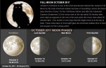
Full “Hunters Moon” 2:40 PM
THURSDAY: A couple mountain sprinkles early, giving way to periods of sunshine. Cooler. A high in the mid 60s. West winds 10 to 20 mph.
Looking further ahead…
THURSDAY NIGHT: Mostly clear northern areas partly to mostly cloudy elsewhere with a chance for a few showers southern areas. A low 45 to 50.
FRIDAY: Alternating clouds & sun after a few morning showers exit. A high around 65.
SATURDAY: Slight chance for a period of light rain showers in the morning, with areas of fog. Mixed clouds and sun in the afternoon. A low in the mid 40s to around 50. A high 60 to 65.
SUNDAY: Partly sunny and kind of muggy after a foggy morning. A low in the upper 50s to low 60s. A high pushing 80 degrees.
MONDAY: More clouds than sun with isolated showers possible. Muggy. A low in the lower 60s. A high 75 to 80.
Average low in the low to mid 40s. Normal highs 60 to 65.
RH/10-4 [end]
| Virus-free. www.avast.com |
