
-

- image00120
-
- image00218
-
- image00316
-
- image00413
-
- image0056
-

- image0062
-
- image0071
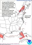
TODAY: Mostly sunny much of today with more clouds northern areas late this afternoon where there could be an isolated late afternoon shower or thunderstorm N. Green Mountains. Muggy, but not as hot with a high in the mid 80s. Southwest winds 10 to 20 mph.
TONIGHT: Partly to mostly cloudy. Widely scattered showers and thunderstorms across northern areas. A low in the mid to upper 50s. Southwest breeze shifting to northwesterly overnight 10 mph.
THURSDAY: Partly to mostly cloudy for a time northern areas, partly sunny Barre-Montpelier area south. Breezy, much cooler and less humid.A high in the low 60s. Northwest winds 10 to 20 mph.
Looking further ahead…
THURSDAY NIGHT: Partly cloudy. A low in the 40s.
FRIDAY: Periods of morning sun giving way to more clouds at times. Seasonally cool and breezy. A high in the upper 50s to low 60s.
SATURDAY: Considerable morning clouds with a few brief showers, giving way to intervals of sun in the afternoon. A low 40 to 45. A high in the upper 50s to low 60s.
SUNDAY: Bright autumn sun after morning fog. A low 35 to 40. Isolated frost possible Northeast Kingdom. A high in the mid 60s.
MONDAY: Mostly sunny. A low in the mid 30s to low 40s. A high in the mid 60s to near 70.
TUESDAY: Partly to mostly sunny skies. And warmer. A low 40 to 45. A high around 70.
Average low mid to upper 40s. Normal highs mid to upper 60s
RH/9-27 [end]
| Virus-free. www.avast.com |
