
-
- image00118
-

- image00216
-
- image00314
-
- image00412
-
- image0051
-
- image006
TODAY: Morning fog burns off to hazy sunshine. Sticky and hot. A record high in the upper 80s to low 90s. Light winds
TONIGHT: Mostly clear with a few high clouds. Patchy valley fog. Muggy with a low 60 to 65. Light south winds.
TUESDAY: Filtered sunshine after morning fog burns off. Hot and sticky. A record high in the upper 80s to low 90s. Little wind.
Looking further ahead…
TUESDAY NIGHT: Mostly clear and muggy. A low 60 to 65.
WEDNESDAY: Partly to mostly sunny with more clouds late. Muggy and continued very warm. A high in the mid to upper 80s.
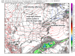
THURSDAY: Isolated leftover mountain showers in the morning, Otherwise partly to mostly cloudy. Breezy , much cooler and less humid.A low 55 to 60. A high 60 to 65.
FRIDAY: Mixed clouds and sun. A low in the 40s. A high in the 50s.
Average low mid to upper 40s. Normal highs mid to upper 60s
RH/9-25 [end]
| Virus-free. www.avast.com |
