
-

- image0014
-
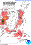
- image0022
-
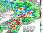
- image0035
TODAY: Mainly cloudy. Showers with isolated thunderstorms developing in the morning. A few storms could locally heavy western and southern Vermont. Muggy with a high around 70. Southeasterly breeze 10 to 20 mph.
TONIGHT: Widely scattered evening showers exiting to partial clearing. Patchy valley fog. A low around 60. Light south winds.
SATURDAY: A few showers maybe an isolated thunderstorm northern areas, otherwise partly sunny, muggy & warmer. A high in the lower 80s.Southwest winds 10 to 15 mph.
Looking further ahead…
SATURDAY NIGHT: Variably cloudy with a chance for a shower or thunderstorm. A low in the mid to upper 50s.
SUNDAY: Morning clouds and fog, then increasing sunshine and pleasant. A high mid to upper 70s.
Partial Eclipse 2:41 PM
MONDAY: Sunshine after morning fog and warmer. A low around 55. A high 80 to 85.
TUESDAY: Partly sunny. Becoming warm and humid. A low in the upper 50s to low 60s. A high in the mid to upper 80s.
WEDNESDAY: Mostly cloudy. Chance for showers and thunderstorms. A low in the low to mid 60s. A high in the upper 60s to mid 70s.
THURSDAY: Partly sunny drier and cooler. A low around 50. A high in the upper 60s to low 70s.
Average low in the low to mid 50s. Normal highs in the low to mid 70s.
RH/8-18 [end]
| Virus-free. www.avast.com |
