
-
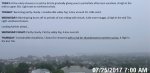
- image0018
-
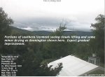
- image0023
-
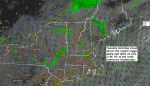
- image0039
TODAY: A few misty showers or patchy drizzle gradually giving way to partial late afternoon sunshine. A high in the mid to upper 60s. Light east to northeast winds.
TONIGHT: Becoming partly cloudy. Considerable valley fog. A low around 50. Little wind.
WEDNESDAY: Morning fog burns off to periods of sun mixing with clouds. A high in the mid 70s. Light southwest breeze.
Looking further ahead…
WEDNESDAY NIGHT: Partly cloudy. Patchy valley fog. A low near 60.
THURSDAY: Considerable cloudiness. Chance for morning showers with a risk for thunderstorms northern areas. Scattered afternoon and early evening showers and thunderstorms. Humid. A high in the low to mid 70s.
FRIDAY: Chance for morning showers exiting partial afternoon sunshine. A low in the upper 50s. A high around 70.
SATURDAY: Increasing sunshine after morning fog. Pleasant and dry. A low around 55. A high in the low 70s.
SUNDAY: Sunny, but with a afternoon clouds. A low in the upper 40s to mid 50s. A high mid 70s to near 80.
MONDAY: Mostly sunny after morning fog. A low in the upper 40s to mid 50s. A high in the low 80s.
Average low mid 50s to 60. Normal highs upper 70s to low 80s.
RH/7-25
| Virus-free. www.avast.com |
