
-
- image0017
-
- image00211
-
- image0037
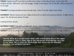
TODAY: Fog burns off to partly to mostly sunny skies. A late day shower or two near the Quebec border. Still warm and a bit muggy. A high in the upper 70s to low 80s. West breeze 10 to 15 mph
TONIGHT: Evening cloudiness then mostly clear. Patchy valley fog. A low 55 to 60. Light west winds.
SATURDAY: Mixed clouds and sun. Slight chance for an afternoon pop up shower. A high mid to upper 70s. Northwest winds 10 mph.
Looking further ahead…
SATURDAY NIGHT: Fair with variable high clouds. Patchy valley fog. A low 55 to 60.
SUNDAY: Lot of sunshine with variable afternoon clouds thickening up late. A high around 75.
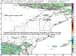
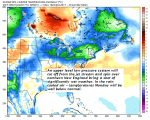
MONDAY: Overcast. A good chance for periods of showers or intermittent rain. Maybe some rumbles of thunder. A low 55 to 60. A high 65 to 70.
TUESDAY: Mostly cloudy. Good chance for leftover showers. A rumble of thunder possible.A low in the mid 50s. A high in the 60s
WEDNESDAY: Mostly sunny and a beauty.A low in the 50s. A high in the 70s.
THURSDAY: Increasing clouds. Chance for showers and possible thunderstorms. A low in the 50s. A high in the 70s.
Average low mid 50s to 60. Normal highs mid 70s to around 80. Climatological peak of summer Saturday…
RH/7-21
